
Restoration Impacts to Avian Populations along the Louisiana Outer Coast
USGS researchers are conducting ground surveys and collecting aerial imagery to understand avian use of restored habitats at Whiskey Island, Shell Island, Cheniere Ronquille, and Breton Island. They will also develop habitat maps to understand how coastal processes and episodic events influence barrier islands.
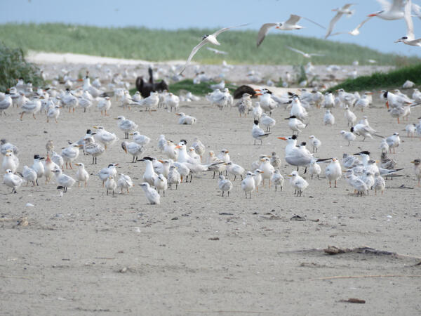
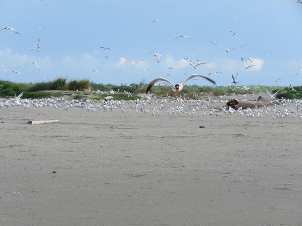
The Science Issue and Relevance: Barrier islands are crucial features along the coastline that protect areas further inland by acting as a buffer from storms and coastal erosion. These islands also provide key habitat to many species of colonial and solitary nesting birds, such as gulls, terns, pelicans, and shorebirds. Anthropogenic and natural forces, such as sea-level rise, severe storms, and erosion, have caused many barrier islands to experience land loss and habitat degradation. To maintain the integrity of barrier islands and headlands, resource managers and coastal engineers use dredged materials to create new islands and restore existing ones. These restoration practices may provide new functional habitats that may help threatened species, such as the piping plover (Charadrius melodus) and red knot (Calidris canutus), in addition to protecting human life and infrastructure. However, resource managers and coastal engineers require a better understanding of how species respond to restoration practices. Monitoring the use of restored islands after restoration can provide resource managers with information that may be used to design restoration projects to better serve species of concern and understand when remediation may be necessary. To provide information on the effectiveness of recent barrier island restoration projects, USGS researchers and their partners are investigating the habitat use, occupancy, and behavior of focal and breeding species (e.g., Figures 1 and 2) on Whiskey Island, Shell Island, Cheniere Ronquille, and Breton Island (Figure 3).
Methodology for Addressing the Issue: Surveys are being conducted across the full annual cycle of migratory birds to understand avian use of restored habitats at Whiskey Island, Shell Island, Cheniere Ronquille, and Breton Island (Figure 3). Ground survey crews are collecting data on abundance and age ratios for all species as well as detailed information on behavior and habitat use for focal species. Aerial imagery is also being collected to provide an additional measure of avian activity on the islands. In addition to the avian data being collected, USGS and partners are developing detailed habitat maps to understand the change that gradual coastal processes (e.g., waves, erosion, and currents) and episodic events (e.g., hurricanes, extreme storms, and wash over events) have on barrier islands. These maps will show changes over time by focusing on land cover type and condition (greenness, wetness, and brightness). While the geospatial data will produce standalone products, these data will be also used to support analyses related to avian surveys by acting as covariates in the analysis. Avian analyses will focus on the occupancy of all bird species, while additional analyses will investigate habitat use and behavior of focal species.
Future Steps: Following the completion of surveys, avian data will be used in conjunction with geographic information systems (GIS) data for analysis. Geospatial products will be developed and released for public use. The results may provide resource managers and coastal engineers with information on the relationship between restored barrier island use by birds over time, which may inform future restoration efforts.


Monitoring Effects of Barrier Island Restoration on Piping Plovers in Louisiana

Understanding Avian Habitat Availability and Use After Barrier Island Restoration in Coastal Louisiana

Seasonal Surveys of Shorebird and Coastal Waterbird Utilization of Dredged Material Islands in the Baptiste Collette Bayou, U.S. Army Corps of Engineers (USACE) New Orleans District, Louisiana

Non-breeding Habitat Use of Flooded Agricultural Fields by Shorebirds within the Mississippi Delta
USGS researchers are conducting ground surveys and collecting aerial imagery to understand avian use of restored habitats at Whiskey Island, Shell Island, Cheniere Ronquille, and Breton Island. They will also develop habitat maps to understand how coastal processes and episodic events influence barrier islands.
The Science Issue and Relevance: Barrier islands are crucial features along the coastline that protect areas further inland by acting as a buffer from storms and coastal erosion. These islands also provide key habitat to many species of colonial and solitary nesting birds, such as gulls, terns, pelicans, and shorebirds. Anthropogenic and natural forces, such as sea-level rise, severe storms, and erosion, have caused many barrier islands to experience land loss and habitat degradation. To maintain the integrity of barrier islands and headlands, resource managers and coastal engineers use dredged materials to create new islands and restore existing ones. These restoration practices may provide new functional habitats that may help threatened species, such as the piping plover (Charadrius melodus) and red knot (Calidris canutus), in addition to protecting human life and infrastructure. However, resource managers and coastal engineers require a better understanding of how species respond to restoration practices. Monitoring the use of restored islands after restoration can provide resource managers with information that may be used to design restoration projects to better serve species of concern and understand when remediation may be necessary. To provide information on the effectiveness of recent barrier island restoration projects, USGS researchers and their partners are investigating the habitat use, occupancy, and behavior of focal and breeding species (e.g., Figures 1 and 2) on Whiskey Island, Shell Island, Cheniere Ronquille, and Breton Island (Figure 3).
Methodology for Addressing the Issue: Surveys are being conducted across the full annual cycle of migratory birds to understand avian use of restored habitats at Whiskey Island, Shell Island, Cheniere Ronquille, and Breton Island (Figure 3). Ground survey crews are collecting data on abundance and age ratios for all species as well as detailed information on behavior and habitat use for focal species. Aerial imagery is also being collected to provide an additional measure of avian activity on the islands. In addition to the avian data being collected, USGS and partners are developing detailed habitat maps to understand the change that gradual coastal processes (e.g., waves, erosion, and currents) and episodic events (e.g., hurricanes, extreme storms, and wash over events) have on barrier islands. These maps will show changes over time by focusing on land cover type and condition (greenness, wetness, and brightness). While the geospatial data will produce standalone products, these data will be also used to support analyses related to avian surveys by acting as covariates in the analysis. Avian analyses will focus on the occupancy of all bird species, while additional analyses will investigate habitat use and behavior of focal species.
Future Steps: Following the completion of surveys, avian data will be used in conjunction with geographic information systems (GIS) data for analysis. Geospatial products will be developed and released for public use. The results may provide resource managers and coastal engineers with information on the relationship between restored barrier island use by birds over time, which may inform future restoration efforts.
Monitoring Effects of Barrier Island Restoration on Piping Plovers in Louisiana
Understanding Avian Habitat Availability and Use After Barrier Island Restoration in Coastal Louisiana
Seasonal Surveys of Shorebird and Coastal Waterbird Utilization of Dredged Material Islands in the Baptiste Collette Bayou, U.S. Army Corps of Engineers (USACE) New Orleans District, Louisiana