Spatial Analysis Support for Coastal Wetlands Planning, Protection and Restoration Act (Breaux Bill) Planning Activities
WARC first implemented geographic information systems (GIS) in 1980 to help monitor the nature and extent of wetland habitat changes. The center continues to use GIS, remote sensing, and other computer based technologies to address a wide range of natural resource related issues.

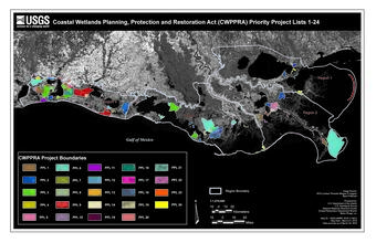
Science Issue and Relevance: The Wetland and Aquatic Research Center (WARC) first implemented geographic information systems (GIS) in 1980 to assist in monitoring the nature and extent of wetland habitat changes. The geospatial capabilities the center, in part, grew out of that initial effort and now use GIS, remote sensing, and other computer based technologies to address a wide range of natural resource related issues. WARC often applies this technology in cooperative ventures with other federal agencies, state and local government, and the private sector. Specifically, WARC has provided the Coastal Wetlands Planning, Protection and Restoration Act (CWPPRA) Task Force, Technical Committee, and Workgroups geospatial support to aid in planning and decision making since 1992.
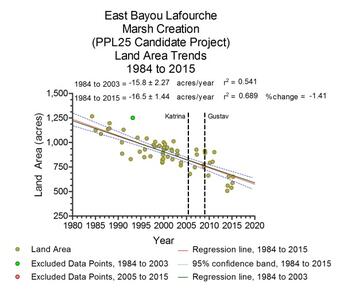
Methodology for Addressing the Issue: Geographers and support staff create, maintain, and utilize various databases and data layers in analysis for restoration efforts in Louisiana. Land/water datasets are created to assess the land change in areas of interest for restoration. Aerial photography is used to determine change at a finer scale and for specific applications, such as shoreline change analysis. WARC has also developed tools for use with the CWPPRA Wetland Value Assessment (WVA) model. The goal is to reduce subjectivity in determining baseline conditions for specific variables.

In addition to planning tools, analysis provided through geospatial support has been absorbed for use in other projects. The Coastwide Reference Monitoring System (CRMS) uses the land change assessment as a landscape indicator in the reporting feature. Also, databases created and maintained for other partners are incorporated onto CRMS, lacoast.gov, SONRIS, and CIMS websites.
Future Steps: In conjunction with CRMS, datasets created are used to further investigate restoration effectiveness. This is an ongoing effort as projects reach their end of project life and new projects are introduced to the landscape.
WARC first implemented geographic information systems (GIS) in 1980 to help monitor the nature and extent of wetland habitat changes. The center continues to use GIS, remote sensing, and other computer based technologies to address a wide range of natural resource related issues.

Science Issue and Relevance: The Wetland and Aquatic Research Center (WARC) first implemented geographic information systems (GIS) in 1980 to assist in monitoring the nature and extent of wetland habitat changes. The geospatial capabilities the center, in part, grew out of that initial effort and now use GIS, remote sensing, and other computer based technologies to address a wide range of natural resource related issues. WARC often applies this technology in cooperative ventures with other federal agencies, state and local government, and the private sector. Specifically, WARC has provided the Coastal Wetlands Planning, Protection and Restoration Act (CWPPRA) Task Force, Technical Committee, and Workgroups geospatial support to aid in planning and decision making since 1992.
Methodology for Addressing the Issue: Geographers and support staff create, maintain, and utilize various databases and data layers in analysis for restoration efforts in Louisiana. Land/water datasets are created to assess the land change in areas of interest for restoration. Aerial photography is used to determine change at a finer scale and for specific applications, such as shoreline change analysis. WARC has also developed tools for use with the CWPPRA Wetland Value Assessment (WVA) model. The goal is to reduce subjectivity in determining baseline conditions for specific variables.

In addition to planning tools, analysis provided through geospatial support has been absorbed for use in other projects. The Coastwide Reference Monitoring System (CRMS) uses the land change assessment as a landscape indicator in the reporting feature. Also, databases created and maintained for other partners are incorporated onto CRMS, lacoast.gov, SONRIS, and CIMS websites.
Future Steps: In conjunction with CRMS, datasets created are used to further investigate restoration effectiveness. This is an ongoing effort as projects reach their end of project life and new projects are introduced to the landscape.

