
Beth Stettner checks out the location of the IWRSS MOU signing.
Images
Images
Filter Total Items: 9454

1935 Stream Gage
Beth Stettner checks out the location of the IWRSS MOU signing.

Devil's Tower
Devil's Tower.

A Channelized Flow Eruption From Pu'u 'O 'o Crater
A Channelized Flow Eruption From Pu'u 'O 'o CraterA channelized flow was being erupted today from the vent on the west side of the floor of Pu'u 'O 'o.
A Channelized Flow Eruption From Pu'u 'O 'o Crater
A Channelized Flow Eruption From Pu'u 'O 'o CraterA channelized flow was being erupted today from the vent on the west side of the floor of Pu'u 'O 'o.

View From The Active Lava Surface in Halema'uma'u Crater
View From The Active Lava Surface in Halema'uma'u CraterA close-up of the active lava surface in Halema'uma'u.
View From The Active Lava Surface in Halema'uma'u Crater
View From The Active Lava Surface in Halema'uma'u CraterA close-up of the active lava surface in Halema'uma'u.

Flooded Cattle Ranch
Cattle Ranch with typically 100 head of cattle currently flooded from the spring melt of higher than average snow accumulation.
Cattle Ranch with typically 100 head of cattle currently flooded from the spring melt of higher than average snow accumulation.

Work Continues. . . .
Work Continues even when Silvies River is about to flood over the bridge.
Our datalogger is attached to the bridge and much to our surprise, a dump truck drives across the bridge as we were contemplating the safety of crossing on foot.
Work Continues even when Silvies River is about to flood over the bridge.
Our datalogger is attached to the bridge and much to our surprise, a dump truck drives across the bridge as we were contemplating the safety of crossing on foot.

Wildlife at Summer Lake Wildlife Area
A pair of pelicans and in the background a Great Blue Heron in a Wetland at Summerlake Wildlife Area.
A pair of pelicans and in the background a Great Blue Heron in a Wetland at Summerlake Wildlife Area.

Work Still Has to Get Done!
Employee collectiing Water Quality data with instrument YSI 556mps handheld in creek swollen from spring melt.
Employee collectiing Water Quality data with instrument YSI 556mps handheld in creek swollen from spring melt.

Snowslip Mountain Weather Station, MT
USGS Physical Scientist Erich Peitzsch sets up a weather station on Snowslip Mountain in Glacier National Park. It provides meteorological data for avalanche forecasting and research, including wind speed and direction, air temperature, relative humidity, and net radiation measurements.
USGS Physical Scientist Erich Peitzsch sets up a weather station on Snowslip Mountain in Glacier National Park. It provides meteorological data for avalanche forecasting and research, including wind speed and direction, air temperature, relative humidity, and net radiation measurements.

Storm is Coming
Storm clouds moving in over the park entrance.
Storm clouds moving in over the park entrance.

Pollinator Hovering
Bumble bee over a cone flower.
Bumble bee over a cone flower.

Bumble Bee Air Traffic Control
Three bumble bees around a cone flower.
Three bumble bees around a cone flower.

Solar Tubes
The new solar heating system will reduce the center's carbon footprint by supplementing the current natural gas boiler and reduce energy costs.
The new solar heating system will reduce the center's carbon footprint by supplementing the current natural gas boiler and reduce energy costs.

Listening
A USGS employee locates a telemetry tagged pallid sturgeon between attempts to recapture the fish with a trammel net in the Missouri River.
A USGS employee locates a telemetry tagged pallid sturgeon between attempts to recapture the fish with a trammel net in the Missouri River.

Elwha River Dam
The 100 yr old, 108 ft tall Elwha Dam drawdown of water from Lake Aldwell reservoir began June 1, 2011 in preparation for Elwha Dam.
The 100 yr old, 108 ft tall Elwha Dam drawdown of water from Lake Aldwell reservoir began June 1, 2011 in preparation for Elwha Dam.

The View From Above
The view of Cougar Dam and the fish facility from the upper cliff side.
The view of Cougar Dam and the fish facility from the upper cliff side.

Welcoming Arriving Canoes from Salish Sea Canoe Journey at Swinomish Tribe
Welcoming Arriving Canoes from Salish Sea Canoe Journey at Swinomish TribeTribal members welcome "families" from other Salish Sea Indian and First Nation Tribes.
Welcoming Arriving Canoes from Salish Sea Canoe Journey at Swinomish Tribe
Welcoming Arriving Canoes from Salish Sea Canoe Journey at Swinomish TribeTribal members welcome "families" from other Salish Sea Indian and First Nation Tribes.

Viewing Pacific Lamprey
Deputy Assistant Secretary Deanna Archuleta tours the Bonneville Dam to view the fish ladder and in particular the native Pacific Lampreys used as first foods by Tribes along the Columbia River.
Deputy Assistant Secretary Deanna Archuleta tours the Bonneville Dam to view the fish ladder and in particular the native Pacific Lampreys used as first foods by Tribes along the Columbia River.
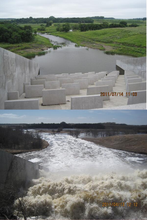
Maple River Dam Spillway Comparison
Maple River Dam spillway comparison in 2011. The top photo was taken on July 14, 2011, with a gage height of 1,027.30 feet and a streamflow of 809 cubic feet per second. The bottom photo was taken on April 13, 2011, with a gage height of 1,052.95 feet and a streamflow of 4,960 cubic feet per second.
Maple River Dam spillway comparison in 2011. The top photo was taken on July 14, 2011, with a gage height of 1,027.30 feet and a streamflow of 809 cubic feet per second. The bottom photo was taken on April 13, 2011, with a gage height of 1,052.95 feet and a streamflow of 4,960 cubic feet per second.

Diver Recording Data
USGS Diver Nancy Elder recording invertebrate data.
USGS Diver Nancy Elder recording invertebrate data.

Pallid Embryo
Pallid sturgeon embryo propagated at the Columbia Environmental Research Center.
Pallid sturgeon embryo propagated at the Columbia Environmental Research Center.