Chandeleur Islands moderate waves weather scenario
Chandeleur Islands moderate waves weather scenarioChandeleur Islands moderate waves weather scenario.

Official websites use .gov
A .gov website belongs to an official government organization in the United States.
Secure .gov websites use HTTPS
A lock () or https:// means you’ve safely connected to the .gov website. Share sensitive information only on official, secure websites.
Images
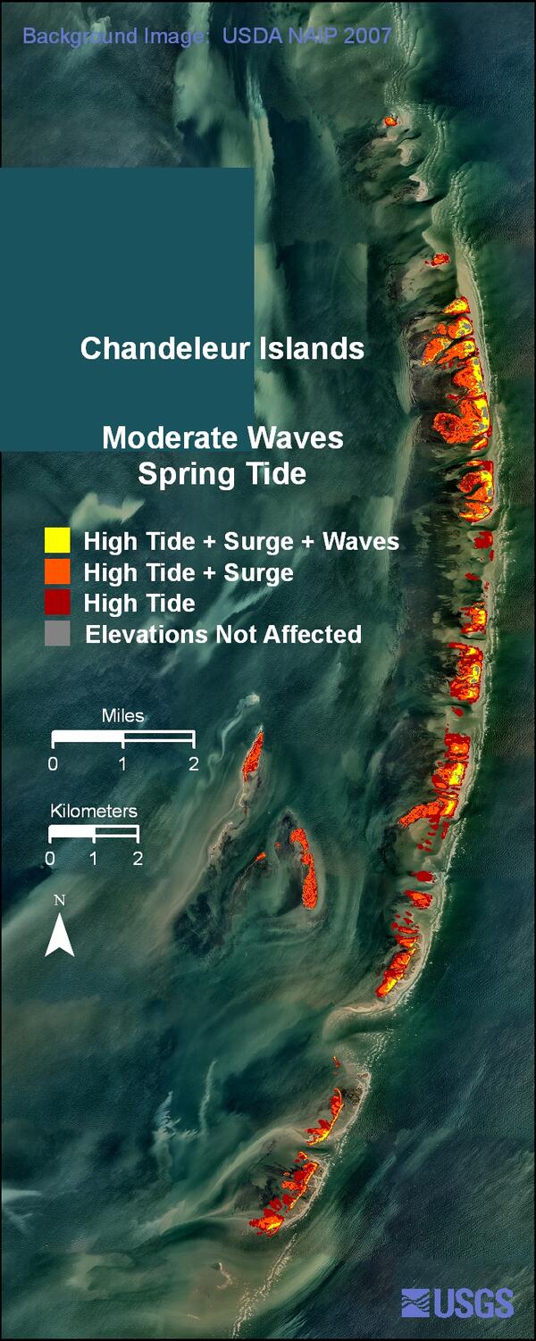
Chandeleur Islands moderate waves weather scenario.
Chandeleur Islands moderate waves weather scenario.
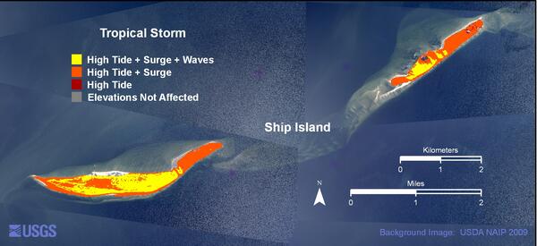
Ship Island tropical storm weather scenario.
Ship Island tropical storm weather scenario.

You may notice a green, red or brown film on your favorite boating or swimming area in the summer. This coloring could mean that the water is affected by harmful algal blooms. Harmful algal blooms are an accumulation of tiny organisms known as algae and can release harmful toxins into the environment. Pictured here is Lake Dora, FL, covered in algal blooms.
You may notice a green, red or brown film on your favorite boating or swimming area in the summer. This coloring could mean that the water is affected by harmful algal blooms. Harmful algal blooms are an accumulation of tiny organisms known as algae and can release harmful toxins into the environment. Pictured here is Lake Dora, FL, covered in algal blooms.

USGS researchers at work at Shark River, Everglades National Park.
USGS researchers at work at Shark River, Everglades National Park.

This photo shows a landslide that deposited disaggregated limestone fragments in river valley.
This photo shows a landslide that deposited disaggregated limestone fragments in river valley.

A Landslide dam located 15 km northwest of Jacmel. The dam has breached and should pose no future hazard.
A Landslide dam located 15 km northwest of Jacmel. The dam has breached and should pose no future hazard.

A clear, conical trap collects emerging aquatic insects on Navigation Pool 8 of the Upper Mississippi River for a USGS study examining the effects of Asian carp on insect-eating birds.
A clear, conical trap collects emerging aquatic insects on Navigation Pool 8 of the Upper Mississippi River for a USGS study examining the effects of Asian carp on insect-eating birds.

View of lava dripping into the ocean on the western edge of the 'Ili'ili ocean entry delta.
View of lava dripping into the ocean on the western edge of the 'Ili'ili ocean entry delta.

Close-up view of the Puhiokalaikini entry.
Close-up view of the Puhiokalaikini entry.

Close-up view of the 'Ili'ili entry.
Close-up view of the 'Ili'ili entry.

The Puhi-o-Kalaikini ocean entry, which is almost 1 km (0.6 mi) long, continues to host a medium size steam plume near the center of the delta. Hidden from view in this photograph, another small plume to the west rises from the same delta, where a stream of lava enters the ocean.
The Puhi-o-Kalaikini ocean entry, which is almost 1 km (0.6 mi) long, continues to host a medium size steam plume near the center of the delta. Hidden from view in this photograph, another small plume to the west rises from the same delta, where a stream of lava enters the ocean.

In addition to filling in several small bays, lava has infiltrated small caves in the seacliff as well. Just a week ago this was a blowhole that occasionally shot seawater high into the air. Fresh lava, visible at the bottom of the pit, has since filled in the cave connecting the blowhole to the sea.
In addition to filling in several small bays, lava has infiltrated small caves in the seacliff as well. Just a week ago this was a blowhole that occasionally shot seawater high into the air. Fresh lava, visible at the bottom of the pit, has since filled in the cave connecting the blowhole to the sea.

The western ocean entry, named Puhiokalaikini, has continued to build its delta to the west. Over the past day, lava filled in this small bay at a remarkable rate. The promontory in the upper right corner of the photograph hosted a popular fishing spot.
The western ocean entry, named Puhiokalaikini, has continued to build its delta to the west. Over the past day, lava filled in this small bay at a remarkable rate. The promontory in the upper right corner of the photograph hosted a popular fishing spot.

Steep view looking west into Pu' u 'Ō 'ō crater. The dominant degassing, obvious in this photo, is from a hole on the eastern wall of the crater.
Steep view looking west into Pu' u 'Ō 'ō crater. The dominant degassing, obvious in this photo, is from a hole on the eastern wall of the crater.

View looking southwest across the Kalapana Gardens subdivision toward the ocean entries in the background. The slightly lighter-colored surface just past the houses and topped by burned trees marks the area recently covered by lava.
View looking southwest across the Kalapana Gardens subdivision toward the ocean entries in the background. The slightly lighter-colored surface just past the houses and topped by burned trees marks the area recently covered by lava.

Mudflats (open water in background) derived via erosion and habitat conversion from former mangrove forests often have a band of mangroves adjacent to the creek bank. Here a researcher accesses a mudflat at high tide to make measurements.
Mudflats (open water in background) derived via erosion and habitat conversion from former mangrove forests often have a band of mangroves adjacent to the creek bank. Here a researcher accesses a mudflat at high tide to make measurements.

Lift nets buried in the forest floor and deployed at high tide permit the estimation of fish density within flooded forests.
Lift nets buried in the forest floor and deployed at high tide permit the estimation of fish density within flooded forests.
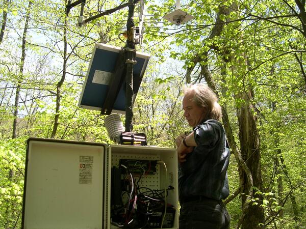
Weather station site, Shenandoah National Park.

By August 17, the breakout which started on August 16 had reached the end Highway 130. The flows, however, had slowed considerably and were making little forward progress.
By August 17, the breakout which started on August 16 had reached the end Highway 130. The flows, however, had slowed considerably and were making little forward progress.

Dead molluscs and raccoon tracks are concentrated in cracks in mud in the substrate of a dried-down tidal pond. Increased frequency and duration of droughts are predicted by some climate models.
Dead molluscs and raccoon tracks are concentrated in cracks in mud in the substrate of a dried-down tidal pond. Increased frequency and duration of droughts are predicted by some climate models.
Block of ice on Vitus Lake, Bering Glacier, Alaska.
Block of ice on Vitus Lake, Bering Glacier, Alaska.