Sharing Proposed 3DEP Areas of Interest
The USGS anticipates funding another round of projects in FY25. The Federal agencies that partner on the 3DEP have compiled their priorities for lidar acquisition and published them on an interactive online map. Overlap with these Federal priorities will be one of the key evaluation criteria. Interested parties are encouraged to share their potential projects through this system in order to assist in finding additional partners for projects.
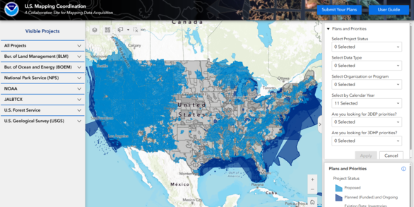
About the U.S. Mapping Coordination site: View Proposed Collection Areas
The 3D Elevation Program and the Interagency Working Group on Ocean and Coastal Mapping have established a system to share information about areas of interest, proposed and planned elevation projects. Planned and potential Federal projects as well as State and local areas of interest are available at the NOAA sponsored U.S. Federal Mapping Coordination, A Collaboration Site for Federal and Partner Mapping Data Acquisition.
All Federal agency and stakeholder areas of interest will be made available for viewing through this site to enable comparison and facilitate discussion with other 3DEP stakeholders. This mapping site is comprehensive, showing areas of interest, proposed, planned, in-work, and completed elevation and related projects. This mapping site is comprehensive, showing areas of interest, proposed, planned, in-work, and completed elevation and related projects.
Viewing Instructions and basic tutorials on how to use the U.S. Mapping Coordination system are available on the U.S. Mapping Coordination website. Alternatively, video lesson 11d below, shows you how to zoom to your area of interest and view the footprints of existing and proposed topographic lidar projects.


")