
What can a homeowner do if a company uses the Lava Flow Hazard Map for Hawai'i Island to set elevated insurance or mortgage rates?
An option is to contact the State of Hawaii Department of Commerce and Consumer Affairs.
The USGS Lava-Flow Hazard Zone Map is meant to convey relative volcanic hazard rather than risk.
A volcanic hazard is a destructive event that can occur in a given area or location, such as a lava flow or a volcanic earthquake, along with the probability of the event's occurrence. It is important to be aware of and understand the hazard, but, in a practical sense, nothing can be done to reduce the hazard itself. Volcanic eruptions and earthquakes are beyond human control.
Risk is the hazard multiplied by the vulnerability (the proportion of some resource, like people or land likely to be affected if the event occurs) multiplied, in turn, by the value (lives or property threatened). In shorthand: Risk = Hazard x Vulnerability x Value.
Risk can be mitigated, meaning that people can take actions to reduce their risk to a particular hazard. Risk assessment and mitigation involve social scientists who have expertise in determining “value” and “vulnerability” as defined in the above formula.
A published study indicating the relative risk of lava inundation in Zones 1 and 2 is not available at this time, so inquiries or complaints about increased rates should go to the respective insurance or mortgage companies.
Learn more: Hawaiian Volcano Observatory Frequently Asked Questions and Answers about Lava-Flow Hazards
Related
How hot is a Hawaiian volcano? How hot is a Hawaiian volcano?
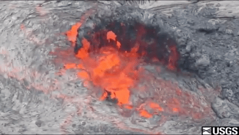
Very hot!! Here are some temperatures recorded at different times and locations: The eruption temperature of Kīlauea lava is about 1,170 degrees Celsius (2,140 degrees Fahrenheit). The temperature of the lava in the tubes is about 1,250 degrees Celsius (2,200 degrees Fahrenheit). The tube system of episode 53 (Pu'u O'o eruption) carried lava for 10 kilometers (6 miles) from the vent to the sea...

Do earthquakes large enough to collapse buildings and roads accompany volcanic eruptions? Do earthquakes large enough to collapse buildings and roads accompany volcanic eruptions?
Not usually. Earthquakes associated with eruptions rarely exceed magnitude 5, and these moderate earthquakes are not big enough to destroy buildings and roads. The largest earthquakes at Mount St. Helens in 1980 were magnitude 5, large enough to sway trees and damage buildings, but not destroy them. During the huge eruption of Mount Pinatubo in the Philippines in 1991, dozens of light to moderate...

What was the most destructive volcanic eruption in the history of the United States? What was the most destructive volcanic eruption in the history of the United States?
The May 18, 1980 eruption of Mount St. Helens (Washington) was the most destructive in the history of the United States. Novarupta (Katmai) Volcano in Alaska erupted considerably more material in 1912, but owing to the isolation and sparse population of the region, there were no human deaths and little property damage. In contrast, the eruption of Mount St. Helens caused loss of lives and...

Where is the largest active volcano in the world? Where is the largest active volcano in the world?
Rising gradually to more than 4 km (2.5 mi) above sea level, Hawaii’s Mauna Loa is the largest active volcano on our planet. Its submarine flanks descend to the sea floor an additional 5 km (3 mi), and the sea floor in turn is depressed by Mauna Loa's great mass another 8 km (5 mi). This makes the volcano's summit about 17 km (10.5 mi) above its base! Learn more: USGS Hawaiian Volcano Observatory
Related
How hot is a Hawaiian volcano? How hot is a Hawaiian volcano?
Very hot!! Here are some temperatures recorded at different times and locations: The eruption temperature of Kīlauea lava is about 1,170 degrees Celsius (2,140 degrees Fahrenheit). The temperature of the lava in the tubes is about 1,250 degrees Celsius (2,200 degrees Fahrenheit). The tube system of episode 53 (Pu'u O'o eruption) carried lava for 10 kilometers (6 miles) from the vent to the sea...
Do earthquakes large enough to collapse buildings and roads accompany volcanic eruptions? Do earthquakes large enough to collapse buildings and roads accompany volcanic eruptions?
Not usually. Earthquakes associated with eruptions rarely exceed magnitude 5, and these moderate earthquakes are not big enough to destroy buildings and roads. The largest earthquakes at Mount St. Helens in 1980 were magnitude 5, large enough to sway trees and damage buildings, but not destroy them. During the huge eruption of Mount Pinatubo in the Philippines in 1991, dozens of light to moderate...
What was the most destructive volcanic eruption in the history of the United States? What was the most destructive volcanic eruption in the history of the United States?
The May 18, 1980 eruption of Mount St. Helens (Washington) was the most destructive in the history of the United States. Novarupta (Katmai) Volcano in Alaska erupted considerably more material in 1912, but owing to the isolation and sparse population of the region, there were no human deaths and little property damage. In contrast, the eruption of Mount St. Helens caused loss of lives and...
Where is the largest active volcano in the world? Where is the largest active volcano in the world?
Rising gradually to more than 4 km (2.5 mi) above sea level, Hawaii’s Mauna Loa is the largest active volcano on our planet. Its submarine flanks descend to the sea floor an additional 5 km (3 mi), and the sea floor in turn is depressed by Mauna Loa's great mass another 8 km (5 mi). This makes the volcano's summit about 17 km (10.5 mi) above its base! Learn more: USGS Hawaiian Volcano Observatory