How hot is a Hawaiian volcano?
Very hot!! Here are some temperatures recorded at different times and locations:
- The eruption temperature of Kīlauea lava is about 1,170 degrees Celsius (2,140 degrees Fahrenheit).
- The temperature of the lava in the tubes is about 1,250 degrees Celsius (2,200 degrees Fahrenheit).
- The tube system of episode 53 (Pu'u O'o eruption) carried lava for 10 kilometers (6 miles) from the vent to the sea. The tubes contained the heat so efficiently that the lava was still a sizzling 1,140 degrees Celsius (2,085 degrees Fahrenheit) when it reached the ocean.
- The color of incandescent rock gives a crude estimate of temperature. Yellow indicates a temperature of about 1,000–1,200 degrees Celsius (1,832–2,192 degrees Fahrenheit). Orange indicates a slightly cooler temperature of about 800–1,000 degrees Celsius (1,472–1,832 degrees Fahrenheit). Red is even cooler, about 600–800 degrees Celsius (1,112–1,472 degrees Fahrenheit).
- The outer surface of erupting lava cools incredibly quickly (by hundreds of degrees per second) when it is first exposed to air.
Learn more:
Related Content
How hot is Yellowstone?
How big are the Hawaiian volcanoes?
What was the largest volcanic eruption in the 20th century?
Where is the largest active volcano in the world?
What is the difference between "magma" and "lava"?
What kind of school training do you need to become a volcanologist?
Can an eruption at one volcano trigger an eruption at another volcano?
How Do Volcanoes Erupt?
How many active volcanoes are there on Earth?
Kīlauea Volcano Erupts
Today's update for June 21st, 2018 will be the last of the daily updates on this USGS feature story. We encourage you to keep checking the USGS Hawaiian Volcano Observatory (HVO) Kīlauea status website for daily activity updates. You can also visit the USGS Facebook page and the USGS Twitter feed as updates become available. For press inquiries, please email volcanomedia@usgs.gov.
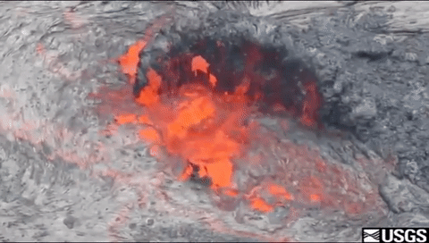
Hovering Above—UAS’ Role in the 2018 Kīlauea Volcano Eruption Response
The 2018 Kīlauea Volcano eruption marked the first time the federal government used Unmanned Aircraft Systems (UAS) to assist in an eruption response in the United States. The UAS were used to survey areas otherwise inaccessible or too hazardous for field crews or manned aircraft, collect multiple types of data, and provide 24/7 real-time situational awareness at Kīlauea
Kīlauea Summit Eruption | Lava Returns to Halemaʻumaʻu
In March 2008, a new volcanic vent opened within Halema‘uma‘u, a crater at the summit of Kīlauea Volcano in Hawaiʻi Volcanoes National Park on the Island of Hawaiʻi. This new vent is one of two ongoing eruptions on the volcano. The other is on Kīlauea’s East Rift Zone, where vents have been erupting nearly nonstop since 1983. The duration of these simultaneous summit and
Taking Lava Temps
In this photo, a USGS researcher is taking a temperature measurement on a sluggish channel eddy on Kīlauea Volcano in 1984. The research in Hawaiʻi is just one of many projects overseen by the USGS Volcano Hazards Program, which monitors active and potentially active volcanoes, assesses their hazards, responds to volcanic crises, and
...Mauna Ulu lava flow on Hawai‘i Island
Mauna Ulu began erupting in May 1969 on Kilauea volcano's east rift zone. Within the first 6 months of erupting 12 lava fountains could be seen, some over 1000 ft high in the air!
PubTalk 12/2011 — Tracking Ongoing Kilauea Eruptions
--fissures...fountains...and flows
by Matthew Patrick, USGS, Hawaiian Volcano Observatory
- Spectacular Kilauea eruptions have produced a summit lava lake, roiling for several years, and a flank eruption recently sending lava flows downslope to threaten residential areas
- How do USGS scientists monitor and track
Lava Lake at Halema'uma'u Crater
The lava lake deep within the vent cavity at Halema'uma'u crater remains active, with ongoing degassing and circulation of lava. This Quicktime movie shows the view in the vent today with a thermal camera, and the video is set at x4 speed to better show the slowly moving lava surface. Today, the lava surface was moving at a rate of about 18 meters per minute (or about 0.7
Thermal Image of Lava Reaching Ocean
This composite image merges a thermal image and normal photograph, and shows the active flow front in Kalapana. Breakouts (shown by white/yellow areas) were present at the base of the pali (uppermost white/yellow areas), in several spots near the County viewing area, and on the fingers of lava feeding the two ocean entries.
Lava Exiting Lava Tube
Lava exited the tube at the sea cliff and poured out onto the growing delta.
Photograph compared with thermal image showing a geologist sampling...
This image shows an HVO geologist sampling the lava that was seeping out of the interior of the rootless shield. The lava was placed in a bucket of water to quench the sample. The top frame is a normal photograph, while the bottom frame is a thermal image taken within a fraction of a second of the photograph. As the thermal image shows, the incandescent interior of the
...Thermal View of Lava Surface Deep within Halema'uma'u
This movie shows the lava surface deep within the Halema'uma'u vent cavity, captured with a thermal camera that can see through the thick fume. The lava surface is about 70 meters (230 ft) wide, and remains about 200 meters (660 ft) below the cavity rim. The surface is mostly crusted, with a slow migration from north to south. Small spattering sources occasionally break
Lava Flow Entering Water
A small open channel of lava was entering the water at one of two entry points at the west Waikupanaha entry area.


