
Frequently Asked Questions and Answers about Lava-Flow Hazards
Frequently Asked Questions and Answers about Lava-Flow Hazards
Why did the U.S. Geological Survey prepare the Lava-Flow Hazard Zone Map for the Island of Hawai‘i?

Kīlauea and Mauna Loa, two of the world’s most active volcanoes, make up the southern half of the island and are covered by lava flows mostly less than 5,000 years old. The Island of Hawaiʻi is covered almost entirely by lava flows erupted over the 500,000 years. Living near a volcano can be both rewarding and hazardous and eruptions are part of life on the Island of Hawaiʻi. One of the most significant hazards associated with Hawaiian volcanoes is the potential for lava flows. The Lava Flow Hazard Zone Map was made to help people to recognize the long-term lava flow impacts that active volcanoes in Hawaii can have on different sectors of the island.
What is a hazard and how does it differ from risk?
In the natural environment, a hazard refers to a natural event or process that has the potential to cause harm, damage, or destruction. Volcanic hazards include lava flows, volcanic gases, and earthquakes. It is important to be aware of and understand the hazard, but nothing can be done to reduce the hazard itself—in other words, volcanic eruptions and earthquakes are beyond human control. Hazard assessments are done by physical scientists, such as the volcanologists at the USGS Hawaiian Volcano Observatory (HVO).
Risk, in the context of the natural environment, refers to the likelihood or probability of a hazard occurring and the potential consequences it may have on people, infrastructure, and the environment. The amount of risk is dependent on the likelihood or probability of encountering the hazard and the severity of the consequences it may have on people, infrastructure and the environment. Risk can be mitigated—in other words, people can take actions to reduce their risk to a particular hazard.
In Hawaii, Mauna Loa and Kīlauea have higher lava flow hazards across the volcanoes, while higher risk is concentrated where communities and infrastructure are exposed to these hazards. However, on Jupiter's volcanically active moon, Io, there are abundant volcanic hazards, but no risk, because human lives and property are not threatened by the eruptions.

What are the hazards related to an individual lava flow?
Lava flows are streams or rivers of molten rock that pour out of a volcano during an eruption. Lava flows present several hazards to nearby communities. Lava flows down the path of least resistance; as it flows, it engulfs and destroys everything in its path, including homes, infrastructure, and agricultural land, and leaves behind a trail of destruction.
Lava flows can vary in speed, thickness, morphology, and volume depending on the characteristics of the volcano and the type of eruption. The size of a lava flow is related to both how much lava is being erupted (effusion rate) and how long the eruption lasts. The speed of a lava flow is related to how fluid it is (viscosity) and terrain it is flowing over. Steeper slopes and confined drainages favor faster moving lava flows. Large and fast lava flows are more hazardous than lava flows that are small and slow because there is less time to act and a larger area is impacted.
What does the Lava-Flow Hazard Zone Map represent?

Some areas of the Island of Hawaiʻi have been inundated by lava flows several times in the past few centuries, while others have not been inundated for thousands of years. The lava flow hazard zone map identifies nine lava-flow hazard zones for the volcanoes on the Island of Hawai‘i. The land area classified under Zone 1 is the most hazardous and includes volcanic vents in the summits and rift zones of Kīlauea and Mauna Loa, Hawai‘i's two most active volcanoes. Zone 9, considered the least hazardous region, consists of Kohala, a volcano that has not erupted for tens of thousands of years.
The hazard zones are designated based on the locations of past eruption sites, which we know because of written records since the early 1800s, oral Hawaiian traditions, detailed geologic mapping, and age determinations of lava flows. The main factors used to delineate the hazard zones are the frequency of lava flow inundation over the past several thousand years and the likely paths of lava flows erupted from those sites (based on topography and the paths of previous lava flows). The hazard zones also take into account structural and topographic features that would affect the direction of lava flows.
The zones indicate relative lava hazard—for example, lava flow hazard zone 3 is more hazardous than lava flow hazard zone 4. The zones do not indicate quantitative hazard—while lava flow hazard zone 1 is more hazardous than lava flow hazard zone 2, it is incorrect to say it is twice as hazardous. The map is based on our best knowledge of vent locations and how often lava flows covered an area in the past.
The hazard map simplifies the detailed geologic maps created for the island by identifying areas where lava flows have occurred most frequently in the past. The lava flow hazard zone map also reflects that hazards are generally greater near vents, where the lava is being erupted from. Other factors affecting hazard zones are steepness of slope and topographic paths, like stream drainages, that can guide lava flows into specific areas.
Are the boundaries between lava-flow hazard zones distinct lines?
No, the boundaries between lava flow hazard zones are approximate and gradational. The degree of hazard from one zone to the next is gradual rather than abrupt, and the change can occur over the distance of about half of mile (a quarter mile for around lava flow hazard zone 1). In other words, the boundary between lava-flow hazard zones is not a sharp line that, in one step, you can cross from one zone into the next: it is indicative on the neighborhood level, but not on the property level. Also, within a single hazard zone, the severity of hazard from one location to the next can vary. For example, the hazards posed by lava flows decreases gradually as the distance from eruptive vents increases.
Due to local topography, however, there can be abrupt changes in the relative lava-flow hazard within a single zone. For example, the hills behind Ninole stand high above the adjacent slopes of Mauna Loa and, consequently, have a much lower lava flow hazard than the surrounding area.
The Lava-Flow Hazard Zone Map is over 30 years old. Is it still accurate?
Yes, the map is still accurate. The lava flow hazard zone map reflects long-term lava-flow hazards based on geologic data—the behavior of Hawaiian volcanoes over several thousand years of eruptive behavior, the distribution and ages of lava flows and volcanic vents, the structure of the volcano, and topography. As the fundamental behavior of Hawaiian volcanoes doesn’t change over short amounts of time, the map conveys the lava flow hazard over the next decades to centuries and longer and remains accurate.
How can Island of Hawai‘i residents determine the lava-flow hazard zones in which their properties are located?

The published Lava-Flow Hazard Zone Map (paper copy) was not intended to be used at a scale necessary to identify individual parcels on the map. Digital mapping software can provide the option of identifying the lava flow hazard zone of a location, although the USGS cautions that the boundaries between zones are a half mile wide (quarter mile around lava flow hazard zone 1), which is not accounted for by digital mapping software.
If you have access to Geographic Information Systems (GIS) software, you can overlay the lava-flow hazard zones and boundaries on a map of the Island of Hawaii. The Hawaii Statewide GIS Program has the Island of Hawaii lava-flow hazard zones geospatial data available for download in a variety of formats. The webpage also allows users to type in a physical address using the search bar in the upper right to identify the lava flow hazard zone of a location.
HVO has also made available a Google Earth kmz file that displays lava-flow hazard zones for the County of Hawai‘i on the Google Earth base. Google Earth is an application freely available to anyone who has Internet connectivity.
How does location near a rift zone affect lava-flow hazards?
A rift zone is marked by vents through which lava is erupted. In other words, it is the first place that lava appears out of the ground and, therefore, the highest hazard area and starting point of lava flows that can then travel downhill.
Kīlauea has two rift zones: the East Rift Zone and the Southwest Rift Zone (the latter is almost totally within Hawai‘i Volcanoes National Park). Mauna Loa has a Northeast Rift Zone and a Southwest Rift Zone. Kīlauea and Mauna Loa rift zones are all assigned lava flow hazard zone 1.
Why is an area freshly covered by lava designated as Zone 2, while another area not recently threatened by lava is designated as Zone 1?
Lava-flow hazard zones reflect the long-term hazard of lava flows, not the short-term hazard. Rate of lava coverage—not how recently lava covered an area—is the basis of long-term lava flow hazard.
Zone 1: "Includes the summits and rift zones of Kīlauea and Mauna Loa (left) where vents have been repeatedly active in historic time." These areas are the most dangerous because all, or nearly all, erupted lava first emerges from the ground within Zone 1.
Zone 2: "Areas adjacent to and downslope of active rift zones." These areas are also hazardous, but somewhat less so, because it takes some time for lava from Zone 1 to reach Zone 2.
As Kīlauea's middle East Rift Zone eruption has proven, damage from lava flows will be greater in Zone 1 than in any other zone over the long term. When the Pu‘u‘ō ‘ō eruption began in January 1983, lava flows immediately and repeatedly covered Zone 1 areas. Zone 2 areas have also been covered by lava during the eruption, but not immediately or repeatedly. In other words, it took some time for lava flows to reach Zone 2 areas, and the threat was not continuous—it depended on which direction and how fast the lava flows moved downslope.
In 2018, Kīlauea's lower East Rift Zone eruption began in Zone 1 and impacted areas in both Zones 1 and 2. Recent Kīlauea summit eruptions have all began in Zone 1.
The 2022 Mauna Loa eruption began in Zone 1 and generated lava flows that traveled into Zone 2.
As a specific example, why is Kalapana in Zone 2, while Leilani Estates is in Zone 1?
Kalapana is about 13 km (8 mi) downslope of Kīlauea's East Rift Zone. During Kīlauea's Pu‘u‘ō‘ō eruption, lava flows took 6 years to first reach Kalapana (in 1989) before the area was more completely inundated with lava over a period of about 9 months in 1990. Lava flows then spared this area for 20 years, until they once again threatened Kalapana Gardens in 2010-2011.
Leilani Estates, on the other hand, is located entirely within Kīlauea's East Rift Zone, and in 2018, an eruption started within, and immediately adjacent to, the subdivision. Prior to 2018, the two most recent lower East Rift Zone eruptions were in 1955, when one of the vents erupted lava along the southernmost present-day boundary of Leilani Estates, and in 1960, when lava inundated the village of Kapoho further to the east.
There is evidence of eruptive vents both north and south of Leilani Estates. But, unfortunately, many of the volcanic features indicative of the active rift zone—craters, cinder cones, steaming vents—are disguised by lush vegetation or have been removed by quarrying or grading, which leads to a false sense of security.
The concern was always "when"—not "if"—the next eruption will occur on Kīlauea's lower East Rift Zone with lava flows directly impacting Leilani Estates. That's exactly what happened in 2018, and what could happen again.
Have lava-flow hazard zone maps been prepared for the other Hawaiian Islands?
In the Hawaiian Islands, there are six volcanoes classified as active: Kīlauea, Mauna Loa, Hualālai, and Mauna Kea on the island of Hawai‘i; Kama‘ehuakanaloa (formerly known as Lō‘ihi), a submarine volcano southeast of Hawai‘i Island; and Haleakalā, on the island of Maui.
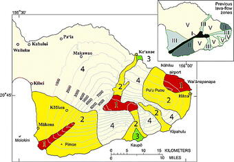
For East Maui, which includes the active volcano Haleakalā, the most current lava-flow hazard zone map can be found in a 2006 paper by D.R. Sherrod and others, available online. The Lava-Flow Hazard Zone classification used for Maui is similar to that used to classify lava-flow hazards on Hawai‘i Island, but, because Haleakalā erupts far less frequently than either Mauna Loa or Kīlauea, the relative hazards on Maui are lower. This means that zone 1 on Maui is much less hazardous than zone 1 on the Island of Hawaii.
The principal author of the 2006 paper by D.R. Sherrod and others, suggests that Maui Zone 1 is roughly equivalent the Island of Hawai‘i Zone 4 designation on Hualalai volcano. An older study by Mullineaux and others (1987) suggests that the area of Maui Zone 3 is roughly equivalent to Island of Hawai‘i lava flow hazard Zone 7, and the hazards in area of Maui Zone 2 are somewhere between that of Maui Zones 1 and 3. In other words, no place on Maui has volcanic hazards equivalent to Lava-Flow Hazard Zones 1, 2, or 3 on the Island of Hawai‘i.
Who prepared the Lava-Flow Hazard Zone Map for the Island of Hawai‘i?
US Geological Survey geologists that specialize in studying volcanic eruptions both in Hawaiʻi and the continental United States prepared the lava flow hazard zone map for the Island of Hawai‘i. The first maps showing volcanic hazard zones on Hawai'i Island were published in 1974 USGS Open-File Report 74-239. The lava-flow hazards map was reformatted in the 1980s, based on new and more complete geologic mapping and lava flow age-dating by USGS scientists. In 1992, the "Map Showing Lava-Flow Hazard Zones, Island of Hawai‘i" was slightly revised and published as USGS Miscellaneous Field Studies Map 2193.
Where can I read more about lava-flow hazards?
- Volcanic hazards in the Hawaiian Islands, chap. 22 (1987) by Mullineaux, D.R., Peterson, D.W., and Crandell, D.R. of Volcanism in Hawaii, Decker, R.W., Wright, T.L., and Stauffer, P.H., eds.; U.S. Geological Survey Professional Paper 1350, v. 1, p. 599-621.
- Distribution, 14C chronology, and paleomagnetism of latest Pleistocene and Holocene lava flows at Haleakalā volcano, Island of Maui, Hawai‘i: A revision of lava flow hazard zones (2006) Journal of Geophysical Research, v. 111, 24 p. Sherrod, D.R., Hagstrum, J.T., McGeehin, J.P., Champion, D.E., and Trusdell, F.A.
Other sources of information about volcanic hazards:
- Eruptions of Hawaiian Volcanoes—Past, Present, and Future (2010) U.S. Geological Survey General Information Product 117, 62 p. Tilling, R.I., Heliker, C., and Swanson, D.A.
- The Story of the Hawaiian Volcano Observatory—A Remarkable First 100 Years of Tracking Eruptions and Earthquakes (2011) U.S. Geological Survey General Information Product 135, 62 p. Babb, J.L., Kauahikaua, J.P., and Tilling, R.I.
- USGS Volcano Hazards Program—Understanding Volcanic Hazards