
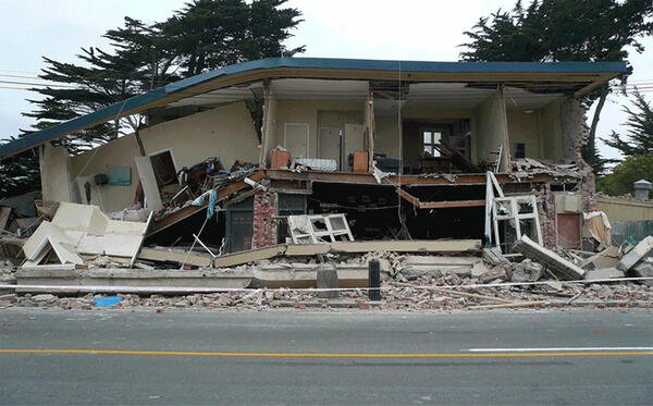
Building damanged by the February 2011 earthquake in Christchurch, New Zealand.
Where can I find a list of the largest earthquakes near my town?
Use our online earthquake catalog to search for past earthquakes in your region. Define your search area by drawing a rectangle on a map or by inputting data for a rectangle or circle.
Go to our Earthquake Information by Region website for information about earthquakes in each state.
Related

Where can I find a list of yearly estimated deaths from earthquakes around the world? Where can I find a list of yearly estimated deaths from earthquakes around the world?
Our Earthquake Lists, Maps, and Statistics website has annual totals for worldwide earthquakes and U.S. earthquakes from 1990 to the near-present. Estimated deaths from those earthquakes are listed at the bottom of the charts. The website also has M3+ earthquake counts by state from 2010 to 2015.

Which states, and other places in the world, have the smallest number of earthquakes? Which states, and other places in the world, have the smallest number of earthquakes?
Florida and North Dakota are the states with the fewest earthquakes. Antarctica has the least earthquakes of any continent, but small earthquakes can occur anywhere in the World. Our Earthquake Lists, Maps, and Statistics website has M3+ earthquake counts for each state from 2010 to 2015. Learn more: Earthquake Information by Region

Where do earthquakes occur? Where do earthquakes occur?
Earthquakes can strike any location at any time, but history shows they occur in the same general patterns year after year, principally in three large zones of the earth: The world's greatest earthquake belt, the circum-Pacific seismic belt, is found along the rim of the Pacific Ocean, where about 81 percent of our planet's largest earthquakes occur. It has earned the nickname "Ring of Fire". Why...

Where can I find a list of the largest earthquakes in the United States or the world? Where can I find a list of the largest earthquakes in the United States or the world?
The USGS Earthquake Lists, Maps, and Statistics website has statistics about earthquakes in the United States and the world, including a list of the world's 20 largest recorded earthquakes.

Which country has the most earthquakes? Which country has the most earthquakes?
The answer to this question is not as straightforward as it may seem. In order to most accurately answer it, we will rephrase the question four different ways: For which country do we locate the most earthquakes? Japan. The whole country is in a very active seismic area, and they have the densest seismic network in the world, so they are able to record many earthquakes. Which country actually has...

Which state has the most earthquakes that cause damage? Which state has the most earthquakes (not human-induced)? Which state has the most earthquakes that cause damage? Which state has the most earthquakes (not human-induced)?
California has more earthquakes that cause damage than any other state. Alaska and California have the most earthquakes (not human-induced). Learn more: Earthquake Information by Region

Where can I search an earthquake catalog for past events? Where can I search an earthquake catalog for past events?
You might be able to find what you’re looking for using our collection of Earthquake Lists, so check that first. If that doesn’t work, use one of these Earthquake Catalog Search webpages: World-wide Earthquakes Catalog (M4.5+ worldwide, M2.5+ U.S.) Historic ANSS (Advanced National Seismic System) Composite Catalog (M4.5+ world-wide, all magnitudes U.S.)
Earthquake-damaged building
Building damanged by the February 2011 earthquake in Christchurch, New Zealand.
Related
Where can I find a list of yearly estimated deaths from earthquakes around the world? Where can I find a list of yearly estimated deaths from earthquakes around the world?
Our Earthquake Lists, Maps, and Statistics website has annual totals for worldwide earthquakes and U.S. earthquakes from 1990 to the near-present. Estimated deaths from those earthquakes are listed at the bottom of the charts. The website also has M3+ earthquake counts by state from 2010 to 2015.
Which states, and other places in the world, have the smallest number of earthquakes? Which states, and other places in the world, have the smallest number of earthquakes?
Florida and North Dakota are the states with the fewest earthquakes. Antarctica has the least earthquakes of any continent, but small earthquakes can occur anywhere in the World. Our Earthquake Lists, Maps, and Statistics website has M3+ earthquake counts for each state from 2010 to 2015. Learn more: Earthquake Information by Region
Where do earthquakes occur? Where do earthquakes occur?
Earthquakes can strike any location at any time, but history shows they occur in the same general patterns year after year, principally in three large zones of the earth: The world's greatest earthquake belt, the circum-Pacific seismic belt, is found along the rim of the Pacific Ocean, where about 81 percent of our planet's largest earthquakes occur. It has earned the nickname "Ring of Fire". Why...
Where can I find a list of the largest earthquakes in the United States or the world? Where can I find a list of the largest earthquakes in the United States or the world?
The USGS Earthquake Lists, Maps, and Statistics website has statistics about earthquakes in the United States and the world, including a list of the world's 20 largest recorded earthquakes.
Which country has the most earthquakes? Which country has the most earthquakes?
The answer to this question is not as straightforward as it may seem. In order to most accurately answer it, we will rephrase the question four different ways: For which country do we locate the most earthquakes? Japan. The whole country is in a very active seismic area, and they have the densest seismic network in the world, so they are able to record many earthquakes. Which country actually has...
Which state has the most earthquakes that cause damage? Which state has the most earthquakes (not human-induced)? Which state has the most earthquakes that cause damage? Which state has the most earthquakes (not human-induced)?
California has more earthquakes that cause damage than any other state. Alaska and California have the most earthquakes (not human-induced). Learn more: Earthquake Information by Region
Where can I search an earthquake catalog for past events? Where can I search an earthquake catalog for past events?
You might be able to find what you’re looking for using our collection of Earthquake Lists, so check that first. If that doesn’t work, use one of these Earthquake Catalog Search webpages: World-wide Earthquakes Catalog (M4.5+ worldwide, M2.5+ U.S.) Historic ANSS (Advanced National Seismic System) Composite Catalog (M4.5+ world-wide, all magnitudes U.S.)
Earthquake-damaged building
Building damanged by the February 2011 earthquake in Christchurch, New Zealand.
Building damanged by the February 2011 earthquake in Christchurch, New Zealand.
Updated Date: February 25, 2022