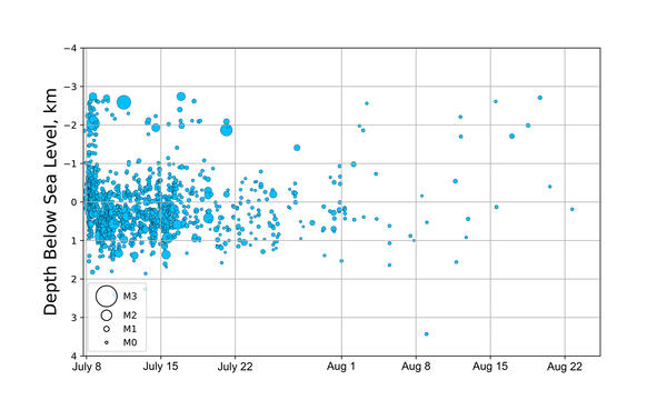
Why do so many earthquakes occur at a depth of 10km?
Ten kilometers is a "fixed depth". Sometimes data are too poor to compute a reliable depth for an earthquake. In such cases, the depth is assigned to be 10 km. Why that number? In many areas around the world, reliable depths tend to average 10 km or close to it. For example, if we made a histogram of the reliable depths in such an area, we'd expect to see a peak around 10 km. So if we don't know the depth, 10 km is a reasonable guess. The USGS used to use 33 km, but increased understanding indicates that 10 km is more likely.
Some areas, like subduction zones, are known to have many earthquakes much deeper than 10 km. In those areas, a deeper fixed depth would probably be appropriate. The most common reason for having to fix the depth is that the earthquake occurred too far from the nearest seismic station. A useful rule of thumb is that a reliable depth requires that the distance from the epicenter to the nearest station must be less than the depth of the earthquake.
Modern computational and theoretical advances can now produce reliable depths at greater distances from the nearest station, so the rule of thumb does not always apply. However, the rule of thumb does illustrate one conclusion: fixed depths are more common for shallow earthquakes than for deep ones.
Related Content
What is UTC, and why do you report earthquakes in UTC?
How quickly is earthquake information posted to the USGS website and sent out via the Earthquake Notification Service (ENS) and other feeds?
Where can I see current or past seismograms?
Why do USGS earthquake magnitudes differ from those published by other agencies?
Why/When does the USGS update the magnitude of an earthquake?
Why do some earthquakes disappear from the map/list?
Why isn't the fault on which the earthquake occurred or the distance to the nearest fault provided?
Can I get on a list to receive an email message when there is an earthquake? How do I sign up for earthquake notifications? Are there any Feeds I can subscribe to?
Did I feel an earthquake? Can I report feeling an earthquake?
Why is the earthquake that was reported/recorded by network X, or that I felt, not on the Latest Earthquakes map/list?
Where can I find current earthquake lists and maps for the world or for a specific area?
Updated USGS Earthquake Monitoring Strategy Released
The USGS Earthquake Hazards Program recently released a new strategic plan for earthquake monitoring entitled the “Advanced National Seismic System – Current Status, Development Opportunities, Priorities, 2017-2027.”
A 100-year-long History of Earthquakes and Seismic Monitoring in Hawaii
The Hawaiian Volcano Observatory’s 1912–2012 Centennial—100 Years of Tracking Eruptions and Earthquakes
HAWAI‘I ISLAND, Hawaii —The history of earthquakes and seismic monitoring in Hawai‘i during the past century will be the topic of a presentation at the University of Hawai‘i at Hilo on Thursday, January 26, at 7:00 p.m.
Millions Awarded for Earthquake Monitoring in the United States
More than $7 million in cooperative agreements will be awarded for earthquake monitoring by the U.S Geological Survey in 2010. This funding will contribute to the development and operation of the USGS Advanced National Seismic System (ANSS).
Recovery Act Funds Will Upgrade Earthquake Monitoring
USGS will Grant Universities $5 Million to Beef Up Public Safety Grants totaling $5 million under the American Recovery and Reinvestment Act are being awarded to 13 universities nationwide to upgrade critical earthquake monitoring networks and increase public safety.
Earthquake Catalog Map Results Example
Example of results returned when searching the USGS Earthquake Catalog. The ANSS Comprehensive Earthquake Catalog (ComCat) contains earthquake source parameters (e.g. hypocenters, magnitudes, phase picks and amplitudes) and other products (e.g. moment tensor solutions, macroseismic information, tectonic summaries, maps) produced by contributing seismic
...Magnitude 6.6 Earthquake in Italy
USGS map of the magnitude 6.6 earthquake in Italy.
Installing Antenna and Solar Panel for Seismic Station
With funding from the American Recovery and Reinvestment Act of 2009, The USGS Hawaiian Volcano Observatory recently upgraded its seismic monitoring network. Here, HVO staff, assisted by an HVO volunteer, installs the solar panel and antenna for one of the upgraded seismic stations on Kīlauea.