
Virginia/West Virginia Water Science Center Glossary
A
Anthropogenic
Anthropogenic
Caused by or originating from human activity

Aquifers
Aquifers
Layers of porous rock or sediment that contains or transmits useable amounts of groundwater.
B
Basement rock
Basement rock
The non-porous continental crust that lies beneath the layers of younger surficial rock and sediments.
Bedload
Bedload
Bedload is the sediment that moves along the bottom of a river and is not suspended in the water column. The friction between the water and the sediment surface causes sediment, like sand, rock, and cobbles, to be moved downstream during high flow events such as storms.

Benthic macroinvertebrate
Benthic macroinvertebrate
Animals that lack a spine and are large enough to be seen with the naked eye which live in the substrate of water bodies such as streams, rivers, ponds, or lakes. Examples include aquatic insects and insect larvae, crayfish, worms, and mollusks.
Borehole extensometers
Borehole extensometers
Instruments used to measure vertical land motion.
C

Confined aquifers
Confined aquifers
Aquifers which have impermeable layers of rock or sediment both above and below. Water cannot freely flow up or down out of the aquifer and can become pressurized.
E
Ecological lift
Ecological lift
An improvement in the biological, chemical, and hydrologic health of an area. Restoring an area that have been damaged by past activity. The goal is to “lift” the site back to a state of ecological functionality so it can support habitats for various species of wildlife.
F
Forebulge collapse
Forebulge collapse
A 'forebulge' is created when the weight of large ice sheets deform the Earth’s crust, creating depressions below them and raised areas (forebulges) adjacent to them. When the ice sheet melts, the raised forebulge starts to collapse as the Earth’s crust readjusts.
G
Geonarrative
Geonarrative
Geonarratives are web applications that combine interactive web maps with narrative text, images, and multimedia content.
I
Impervious surfaces
Impervious surfaces
Areas that allow little to no water to pass through them. Impervious surfaces block infiltration and groundwater recharge and promote runoff.
L
Land Subsidence
Land Subsidence
A loss of ground elevation caused by natural and/or anthropogenic factors such as groundwater depletion & aquifer compaction, sinkhole formation, soil oxidation, or mine collapse.
Loads
Loads
Loads are defined as the mass of nutrient or sediment passing a monitored location per unit time.
M
Mine benches
Mine benches
Artificially flat areas cut into the hillside near mining operations. Mine benches were often used to access mining locations, and to transport mined material away from the mine.
N
Nontidal Rivers
Nontidal Rivers
Rivers, or portions of rivers, that are far enough inland that they are not affected by tidal forces.
P
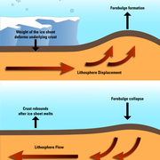
Post-glacial isostatic adjustment
Post-glacial isostatic adjustment
The vertical movement (rising or sinking) of the earth’s crust that occurs over tens of thousands of years after a large ice sheet retreats. The weight of ice sheets deform the ground beneath them, and after they retreat the ground may rise or fall to regain equilibrium.
R
Rainwater infiltration
Rainwater infiltration
When rain soaks directly into the ground and slowly travels downward towards the water table to become groundwater.
Relative Sea Level
Relative Sea Level
How the height of the ocean rises or falls relative to the land at a particular location.
Runoff
Runoff
Water that flows downhill over the ground surface. The portion of precipitation that doesn't infiltrate into the ground flows as runoff into the nearest body of water.
S

Sonde
Sonde
A sonde is an instrument probe that collects and transmits information about its surroundings. For example, a water quality sonde may collect readings on water temperature, pH, dissolved oxygen, turbidity, and more.
Source water
Source water
Sources of water, such as rivers, streams, or groundwater, that provide water to public drinking water supplies and private drinking water wells.
T
Teleseismic waves
Teleseismic waves
Seismic waves generated by distant earthquakes that have travelled long distances through the Earth's subsurface.
Total Maximum Daily Load
Total Maximum Daily Load
A Total Maximum Daily Load, or TMDL, is a plan for restoring an impaired body of water. Sometimes called a "pollution diet", a TMDL identifies the maximum amount of a pollutant that a body of water can receive while still meeting water quality standards.
Trends
Trends
The change over time in a set of data. Can indicate whether a measured parameter is increasing or decreasing over time or showing no significant trend.
V
Virginia Coastal Plain
Virginia Coastal Plain
The easternmost region of Virginia, east of the Piedmont region, between the fall line’ and Chesapeake Bay. This region is characterized by a relatively shallow water table, low elevation, and flat topographic relief. Also known as the Virginia Tidewater region.