
Central Valley Hydrologic Model - Version 2
A new tool for evaluating water management strategies in California’s Central Valley
California’s San Joaquin Valley is one of the most productive farming regions in the world. However, heavy use of groundwater has caused the land to sink—a problem that started in the 1900s and still continues.
To better understand and manage this issue, scientists from CAWSC’s Groundwater Availability and Use Assessments Program have developed the Central Valley Hydrologic Model 2 (CVHM2). This tool helps simulate how water moves through the region and how different actions might affect the land through the year 2073. CVHM2 simulates how three key factors might affect land sinking: farming water use, efforts to refill underground water (aquifer recharge), and future climate shifts.
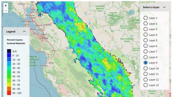
CVHM2 includes a 3D framework of underground sediments, showing how they vary across the valley. The framework uses data from nearly 14,700 boreholes—up from 8,500 in the earlier version of CVHM1—and maps the amount of coarse materials at different depths, from the surface down to 2,800 feet. An interactive map on the website shows how much coarse material is in each layer of the model (screenshot below).
CVHM2 is supported by nine input data sets. This tool can be used analyze changes in groundwater availability and subsidence that can be used to inform necessary water management decisions.