
The West Sacramento Projects Office is the primary home the CAWSC Hydrodynamics and Ecology Program and also houses members of the Biogeochemistry group. These are pictures of the facility.
Steve Ackley (Former Employee)
Science and Products
Filter Total Items: 126

Sentinel Site Modeling
The California Department of Fish and Wildlife (CDFW) installed more than 40 climate and biodiversity monitoring stations, called sentinel sites, on public lands across the state. These sites collect detailed data on things like temperature, precipitation, soil moisture, and more to track how the environment is changing. Each site is meant to reflect conditions in the surrounding area, but...

In situ chlorophyll fluorometer validation and comparison study
The Sacramento-San Joaquin Delta (Delta) supplies drinking water to much of California. The Delta also provides irrigation water to the Central Valley and is an important habitat to many aquatic and terrestrial species. In the past decade, there has been an increase in harmful algal blooms (HABs) in the Delta. While some HABs are nontoxic, others contain cyanobacteria that can produce dangerous...

Evaluating the Geohydrology in the San Gorgonio Pass Area
The San Gorgonio Pass, in southern California, is located between the San Bernardino and San Jacinto Mountain ranges. The mountain ranges to either side of the pass rise almost 9,000 feet (2,700 meters) above. The San Gorgonio Pass serves as a corridor for U.S. Interstate 10. It is also known for its strong winds that make it a popular spot for wind turbine energy production.

Water Availability of the Salton Sea Watershed
Throughout history, the Salton Sea has formed and dried up due to flooding from the Colorado River. It was most recently formed in 1905 when the Colorado River broke through an irrigation canal and flowed uncontrolled into the Salton Sea watershed. The Salton Sea is a terminal lake (it has no outlets). It is also a transboundary watershed, with area in both the state of California and Mexico’s...

Drought in California
The USGS closely monitors the occurence and effects of drought through data collection and research. USGS science supports water managers in preparing for possible future drought by providing information about long-term hydrologic, climatic, and environmental changes. These studies support successful planning and science-based decision-making by water managers who must address complex issues and...

Wildfires in California
Over the last several decades, both the incidence of large wildfires and the duration of the wildfire season across much of the United States have increased (Westerling and others, 2006, American Water Works Assn, 2008; Finco and others, 2012). Future wildfire projections based on forecasted climate scenarios indicate both an increase in the expected severity of wildfires, and an expansion of...

High-frequency Monitoring of Delta Island Drainage Waters
From the second half of the 19th century, land reclamation has transformed the Sacramento-San Joaquin Delta (Delta). The landscape of the Delta has gone from a network of shifting waterways and tidal marshland to channels and islands fixed in position by hardened levees.

Water-Quality Monitoring in the Sepulveda Flood Control Basin of the Los Angeles River Watershed
As part of the Urban Waters Federal Partnership (UWFP), this project will enhance water-quality monitoring on a reach of the Los Angeles River slated for revitalization. The UWFP reconnects urban communities—particularly those that are overburdened or economically distressed—with their waterways by improving coordination among federal agencies.

Emergency Drought Barrier’s Impacts on cyanoHABs and Water Quality
Drought is making the Delta Saltier. Less freshwater coming from watershed runoff and reservoir releases means that more salty water flows into the Sacramento San Joaquin Delta (Delta) from the Pacific Ocean. Changes in Delta salinity have far-reaching impacts, affecting the water supply for agriculture, drinking, wildlife, and Delta ecosystems.

Incorporating Impacts of Wildfire and Vegetation Recovery into a Watershed Model of the Feather River Basin
Changes in vegetation in a large watershed due to wildfire can have a substantial influence on actual evapotranspiration rates and water availability. After a large, intense wildfire, evapotranspiration rates are expected to decrease. As vegetation reestablishes, the evapotranspiration rates increase over a period of years, back to pre-fire conditions. Watershed models typically use input layers...
Assessing impacts of wildfire on water and habitat quality in downstream aquatic ecosystems using remote sensing
This project focuses on the downstream effects of wildfires on lakes, reservoirs, and coastal water within the larger context of the USGS project on Post-fire Hazards and Impacts to Resources and Ecosystems (PHIRE): Support for Response, Recovery, and Mitigation. The overall objective of this work is to leverage the historic satellite remote sensing record to provide insight on the impact of...

Salinas Valley Operational Model: Interlake Tunnel and San Antonio Spillway Modification Project
An operational model for Salinas Valley is needed to evaluate and compare ecosystem, conservation, and water demands. This model must simulate current operations, assess benefits of and evaluate scenarios for tunnel operation and potential reservoir and spillway modifications.
Filter Total Items: 27

West Sacramento Projects Office
The West Sacramento Projects Office is the primary home the CAWSC Hydrodynamics and Ecology Program and also houses members of the Biogeochemistry group. These are pictures of the facility.
 Transport Dynamics by Sampling Toxins in Shellfish")
Understanding Harmful Algal Bloom (HAB) Transport Dynamics by Sampling Toxins in Shellfish
Understanding Harmful Algal Bloom (HAB) Transport Dynamics by Sampling Toxins in ShellfishThese photos are of shellfish sampling which took place at Martinez Harbor in Contra Costa County, California on December 18, 2025. For this study, shellfish traps were baited and deployed for two days in the water before being retrieved. All shellfish were collected, species identified, and individuals measured with calipers. These photos show P.
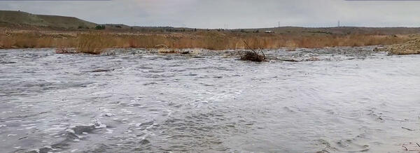
Mojave River during high flow
This picture shows the Mojave River in southern California during a high flow stage.
This picture shows the Mojave River in southern California during a high flow stage.
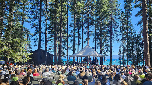
Crowd gathered at 2025 Tahoe Summit
Crown gathered at 2025 Tahoe Summit. The Lake Tahoe Summit is an annual event that brings local, federal, and state leaders together to discuss ways to protect Lake Tahoe and strengthen the partnership underlying the Lake Tahoe Environmental Improvement Program.
Crown gathered at 2025 Tahoe Summit. The Lake Tahoe Summit is an annual event that brings local, federal, and state leaders together to discuss ways to protect Lake Tahoe and strengthen the partnership underlying the Lake Tahoe Environmental Improvement Program.
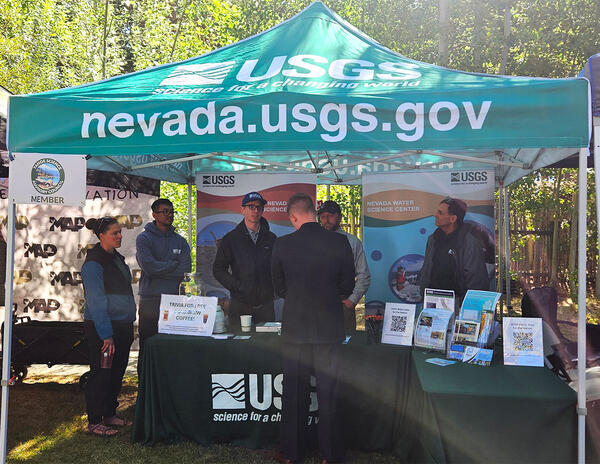
USGS booth at 2025 Tahoe Summit.
USGS booth at 2025 Tahoe Summit. Pictured from left, Sara Doyle (NV WSC), Zach Hood (NV WSC), David Smith (NV WSC), Ed Parvin (CAWSC) and Mark Dickman (CAWSC). Photograph by Ramon Naranjo (NV WSC) on 8/6/25.
USGS booth at 2025 Tahoe Summit. Pictured from left, Sara Doyle (NV WSC), Zach Hood (NV WSC), David Smith (NV WSC), Ed Parvin (CAWSC) and Mark Dickman (CAWSC). Photograph by Ramon Naranjo (NV WSC) on 8/6/25.
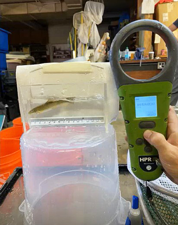
PIT tag reader being tested
This photo shows a passive integrated transponder (PIT) tag reader being used to test a tagged Santa Ana Sucker.
This photo shows a passive integrated transponder (PIT) tag reader being used to test a tagged Santa Ana Sucker.
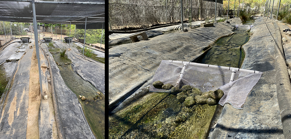
Raceways at the RCD facility
The above photos show raceways at the Riverside Corona Resource Conservation District (RCD) facility.
The above photos show raceways at the Riverside Corona Resource Conservation District (RCD) facility.

Santa Ana Sucker research team
The photo shows members of the research team. From left to right: Tevin Bui (RCD), Jordan Buxton (USGS), Brett Mills (RCD), Alicia Ruan (RCD), and Brock Huntsman (USGS). Inset at right are Marissa Wulff (top) and Jeff Gronemyer (bottom), both of the USGS.
The photo shows members of the research team. From left to right: Tevin Bui (RCD), Jordan Buxton (USGS), Brett Mills (RCD), Alicia Ruan (RCD), and Brock Huntsman (USGS). Inset at right are Marissa Wulff (top) and Jeff Gronemyer (bottom), both of the USGS.
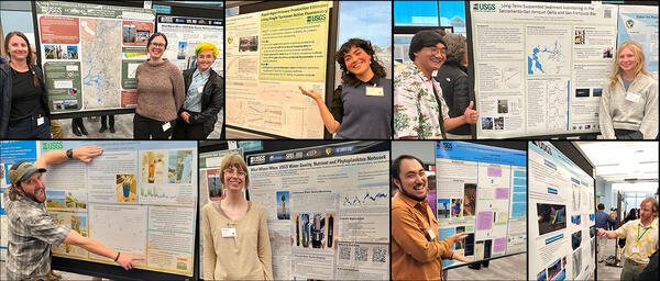
Poster Presenters at 2025 IEP Workshop
CAWSC poster presenters at 2025 IEP Workshop. Clockwise from upper left: Anna Conlen, Elise Shea, Lex Thomas, Zoё Siman-Tov, Bryan Gopez, Emma Walker, David Hart, Maura Uebner, Lawrence Fujiwara, Trevor Violette.
CAWSC poster presenters at 2025 IEP Workshop. Clockwise from upper left: Anna Conlen, Elise Shea, Lex Thomas, Zoё Siman-Tov, Bryan Gopez, Emma Walker, David Hart, Maura Uebner, Lawrence Fujiwara, Trevor Violette.

CAWSC Biogeochemistry group at 2025 IEP Workshop
CAWSC Biogeochemistry group at 2025 IEP Workshop. Left to Right: Back Row - Maura Uebner, Keith Bouma-Gregson, Kyle Leathers; Middle Row - Crystal Sturgeon, Zoё Siman-Tov, Lane Bratz, Emily Richardson, Tamara Kraus, Alex Ryan; Front Row - Nick Framsted
CAWSC Biogeochemistry group at 2025 IEP Workshop. Left to Right: Back Row - Maura Uebner, Keith Bouma-Gregson, Kyle Leathers; Middle Row - Crystal Sturgeon, Zoё Siman-Tov, Lane Bratz, Emily Richardson, Tamara Kraus, Alex Ryan; Front Row - Nick Framsted

Active (or moving) camera footage of Santa Ana Sucker
Active (or moving) camera footage of Santa Ana SuckerActive (or moving) camera footage of Santa Ana Sucker (Pantosteus santaanae). Cameras were attached to “selfie sticks” and walked up and down the raceways (or fabricated streams).
Active (or moving) camera footage of Santa Ana Sucker
Active (or moving) camera footage of Santa Ana SuckerActive (or moving) camera footage of Santa Ana Sucker (Pantosteus santaanae). Cameras were attached to “selfie sticks” and walked up and down the raceways (or fabricated streams).

Open-source image recognition footage of Santa Ana Sucker lure
Open-source image recognition footage of Santa Ana Sucker lureAn open-source image recognition program was used to detect the fish and lures in the videos. The program was “trained” to recognize the fish and lures by exposing it to approximately 800 images of fish and non-fish.

Historical photo is of the Malakoff Diggins hydraulic gold mine
Historical photo is of the Malakoff Diggins hydraulic gold mineHistorical photo of the Malakoff Diggins hydraulic gold mine in the Sierra Nevada in California.
Historical photo is of the Malakoff Diggins hydraulic gold mine
Historical photo is of the Malakoff Diggins hydraulic gold mineHistorical photo of the Malakoff Diggins hydraulic gold mine in the Sierra Nevada in California.

Sample map - Legacy Mercury Contamination in California’s Sierra Nevada
Sample map - Legacy Mercury Contamination in California’s Sierra NevadaSample map - Legacy Mercury Contamination in California’s Sierra Nevada. This map show locations of remediation efforts.
Sample map - Legacy Mercury Contamination in California’s Sierra Nevada
Sample map - Legacy Mercury Contamination in California’s Sierra NevadaSample map - Legacy Mercury Contamination in California’s Sierra Nevada. This map show locations of remediation efforts.

Legacy Mercury Contamination from Historical Gold Mining
Legacy Mercury Contamination from Historical Gold MiningMercury contamination from historic gold mining represents a potential risk to human health and the environment. There is a lack of public awareness of the history mercury use in gold mining and how it contributed to this situation, and also what the present concerns are. Specifically, the public is not aware of locations and levels of contamination.

Photo of members of the team associated with USGS research done in collaboration with UC Davis.
Photo of members of the team associated with USGS research done in collaboration with UC Davis.The above photo includes members of the team associated with research done in collaboration with UC Davis. From left to right, Angela DePalma-Dow (Lake County, conference co-organizer), Sergio Valbuena (UC Davis), Charles Alpers (USGS), Alicia Cortes (UC Davis), and Samantha Sharp (UC Davis).

Attaching solar panel and antennae
USGS scientists attaching solar panel and antennae to soil moisture response unit.
USGS scientists attaching solar panel and antennae to soil moisture response unit.

Squirrel Creek Panorama
Panorama of area near Squirrel Creek soil moisture response unit installation in California's Feather River watershed.
Panorama of area near Squirrel Creek soil moisture response unit installation in California's Feather River watershed.

Digging pit for the soil moisture sensors
A team member helps dig the pit for the soil moisture sensors in the Plumas National Forest in California. Inset: close-up of soil removed from Squirrel Creek pit.
A team member helps dig the pit for the soil moisture sensors in the Plumas National Forest in California. Inset: close-up of soil removed from Squirrel Creek pit.

Soil moisture sensors positioned in pit.
Soil moisture sensors positioned in pit at different depths. Inset: close-up of sensor showing the two probes that gather the data.
Soil moisture sensors positioned in pit at different depths. Inset: close-up of sensor showing the two probes that gather the data.

Soil moisture monitoring station mast assembly
Shown clockwise from top left are: 1] setting up mast to support the station components, 2] installing data logging and transmitting equipment, 3] attaching solar panel and antennae, 4] finished assembly.
Shown clockwise from top left are: 1] setting up mast to support the station components, 2] installing data logging and transmitting equipment, 3] attaching solar panel and antennae, 4] finished assembly.
Science and Products
Filter Total Items: 126
Sentinel Site Modeling
The California Department of Fish and Wildlife (CDFW) installed more than 40 climate and biodiversity monitoring stations, called sentinel sites, on public lands across the state. These sites collect detailed data on things like temperature, precipitation, soil moisture, and more to track how the environment is changing. Each site is meant to reflect conditions in the surrounding area, but...
In situ chlorophyll fluorometer validation and comparison study
The Sacramento-San Joaquin Delta (Delta) supplies drinking water to much of California. The Delta also provides irrigation water to the Central Valley and is an important habitat to many aquatic and terrestrial species. In the past decade, there has been an increase in harmful algal blooms (HABs) in the Delta. While some HABs are nontoxic, others contain cyanobacteria that can produce dangerous...
Evaluating the Geohydrology in the San Gorgonio Pass Area
The San Gorgonio Pass, in southern California, is located between the San Bernardino and San Jacinto Mountain ranges. The mountain ranges to either side of the pass rise almost 9,000 feet (2,700 meters) above. The San Gorgonio Pass serves as a corridor for U.S. Interstate 10. It is also known for its strong winds that make it a popular spot for wind turbine energy production.
Water Availability of the Salton Sea Watershed
Throughout history, the Salton Sea has formed and dried up due to flooding from the Colorado River. It was most recently formed in 1905 when the Colorado River broke through an irrigation canal and flowed uncontrolled into the Salton Sea watershed. The Salton Sea is a terminal lake (it has no outlets). It is also a transboundary watershed, with area in both the state of California and Mexico’s...
Drought in California
The USGS closely monitors the occurence and effects of drought through data collection and research. USGS science supports water managers in preparing for possible future drought by providing information about long-term hydrologic, climatic, and environmental changes. These studies support successful planning and science-based decision-making by water managers who must address complex issues and...
Wildfires in California
Over the last several decades, both the incidence of large wildfires and the duration of the wildfire season across much of the United States have increased (Westerling and others, 2006, American Water Works Assn, 2008; Finco and others, 2012). Future wildfire projections based on forecasted climate scenarios indicate both an increase in the expected severity of wildfires, and an expansion of...
High-frequency Monitoring of Delta Island Drainage Waters
From the second half of the 19th century, land reclamation has transformed the Sacramento-San Joaquin Delta (Delta). The landscape of the Delta has gone from a network of shifting waterways and tidal marshland to channels and islands fixed in position by hardened levees.
Water-Quality Monitoring in the Sepulveda Flood Control Basin of the Los Angeles River Watershed
As part of the Urban Waters Federal Partnership (UWFP), this project will enhance water-quality monitoring on a reach of the Los Angeles River slated for revitalization. The UWFP reconnects urban communities—particularly those that are overburdened or economically distressed—with their waterways by improving coordination among federal agencies.
Emergency Drought Barrier’s Impacts on cyanoHABs and Water Quality
Drought is making the Delta Saltier. Less freshwater coming from watershed runoff and reservoir releases means that more salty water flows into the Sacramento San Joaquin Delta (Delta) from the Pacific Ocean. Changes in Delta salinity have far-reaching impacts, affecting the water supply for agriculture, drinking, wildlife, and Delta ecosystems.
Incorporating Impacts of Wildfire and Vegetation Recovery into a Watershed Model of the Feather River Basin
Changes in vegetation in a large watershed due to wildfire can have a substantial influence on actual evapotranspiration rates and water availability. After a large, intense wildfire, evapotranspiration rates are expected to decrease. As vegetation reestablishes, the evapotranspiration rates increase over a period of years, back to pre-fire conditions. Watershed models typically use input layers...
Assessing impacts of wildfire on water and habitat quality in downstream aquatic ecosystems using remote sensing
This project focuses on the downstream effects of wildfires on lakes, reservoirs, and coastal water within the larger context of the USGS project on Post-fire Hazards and Impacts to Resources and Ecosystems (PHIRE): Support for Response, Recovery, and Mitigation. The overall objective of this work is to leverage the historic satellite remote sensing record to provide insight on the impact of...
Salinas Valley Operational Model: Interlake Tunnel and San Antonio Spillway Modification Project
An operational model for Salinas Valley is needed to evaluate and compare ecosystem, conservation, and water demands. This model must simulate current operations, assess benefits of and evaluate scenarios for tunnel operation and potential reservoir and spillway modifications.
Filter Total Items: 27
West Sacramento Projects Office
The West Sacramento Projects Office is the primary home the CAWSC Hydrodynamics and Ecology Program and also houses members of the Biogeochemistry group. These are pictures of the facility.
The West Sacramento Projects Office is the primary home the CAWSC Hydrodynamics and Ecology Program and also houses members of the Biogeochemistry group. These are pictures of the facility.
Understanding Harmful Algal Bloom (HAB) Transport Dynamics by Sampling Toxins in Shellfish
Understanding Harmful Algal Bloom (HAB) Transport Dynamics by Sampling Toxins in ShellfishThese photos are of shellfish sampling which took place at Martinez Harbor in Contra Costa County, California on December 18, 2025. For this study, shellfish traps were baited and deployed for two days in the water before being retrieved. All shellfish were collected, species identified, and individuals measured with calipers. These photos show P.
Mojave River during high flow
This picture shows the Mojave River in southern California during a high flow stage.
This picture shows the Mojave River in southern California during a high flow stage.
Crowd gathered at 2025 Tahoe Summit
Crown gathered at 2025 Tahoe Summit. The Lake Tahoe Summit is an annual event that brings local, federal, and state leaders together to discuss ways to protect Lake Tahoe and strengthen the partnership underlying the Lake Tahoe Environmental Improvement Program.
Crown gathered at 2025 Tahoe Summit. The Lake Tahoe Summit is an annual event that brings local, federal, and state leaders together to discuss ways to protect Lake Tahoe and strengthen the partnership underlying the Lake Tahoe Environmental Improvement Program.
USGS booth at 2025 Tahoe Summit.
USGS booth at 2025 Tahoe Summit. Pictured from left, Sara Doyle (NV WSC), Zach Hood (NV WSC), David Smith (NV WSC), Ed Parvin (CAWSC) and Mark Dickman (CAWSC). Photograph by Ramon Naranjo (NV WSC) on 8/6/25.
USGS booth at 2025 Tahoe Summit. Pictured from left, Sara Doyle (NV WSC), Zach Hood (NV WSC), David Smith (NV WSC), Ed Parvin (CAWSC) and Mark Dickman (CAWSC). Photograph by Ramon Naranjo (NV WSC) on 8/6/25.
PIT tag reader being tested
This photo shows a passive integrated transponder (PIT) tag reader being used to test a tagged Santa Ana Sucker.
This photo shows a passive integrated transponder (PIT) tag reader being used to test a tagged Santa Ana Sucker.
Raceways at the RCD facility
The above photos show raceways at the Riverside Corona Resource Conservation District (RCD) facility.
The above photos show raceways at the Riverside Corona Resource Conservation District (RCD) facility.
Santa Ana Sucker research team
The photo shows members of the research team. From left to right: Tevin Bui (RCD), Jordan Buxton (USGS), Brett Mills (RCD), Alicia Ruan (RCD), and Brock Huntsman (USGS). Inset at right are Marissa Wulff (top) and Jeff Gronemyer (bottom), both of the USGS.
The photo shows members of the research team. From left to right: Tevin Bui (RCD), Jordan Buxton (USGS), Brett Mills (RCD), Alicia Ruan (RCD), and Brock Huntsman (USGS). Inset at right are Marissa Wulff (top) and Jeff Gronemyer (bottom), both of the USGS.
Poster Presenters at 2025 IEP Workshop
CAWSC poster presenters at 2025 IEP Workshop. Clockwise from upper left: Anna Conlen, Elise Shea, Lex Thomas, Zoё Siman-Tov, Bryan Gopez, Emma Walker, David Hart, Maura Uebner, Lawrence Fujiwara, Trevor Violette.
CAWSC poster presenters at 2025 IEP Workshop. Clockwise from upper left: Anna Conlen, Elise Shea, Lex Thomas, Zoё Siman-Tov, Bryan Gopez, Emma Walker, David Hart, Maura Uebner, Lawrence Fujiwara, Trevor Violette.
CAWSC Biogeochemistry group at 2025 IEP Workshop
CAWSC Biogeochemistry group at 2025 IEP Workshop. Left to Right: Back Row - Maura Uebner, Keith Bouma-Gregson, Kyle Leathers; Middle Row - Crystal Sturgeon, Zoё Siman-Tov, Lane Bratz, Emily Richardson, Tamara Kraus, Alex Ryan; Front Row - Nick Framsted
CAWSC Biogeochemistry group at 2025 IEP Workshop. Left to Right: Back Row - Maura Uebner, Keith Bouma-Gregson, Kyle Leathers; Middle Row - Crystal Sturgeon, Zoё Siman-Tov, Lane Bratz, Emily Richardson, Tamara Kraus, Alex Ryan; Front Row - Nick Framsted
Active (or moving) camera footage of Santa Ana Sucker
Active (or moving) camera footage of Santa Ana SuckerActive (or moving) camera footage of Santa Ana Sucker (Pantosteus santaanae). Cameras were attached to “selfie sticks” and walked up and down the raceways (or fabricated streams).
Active (or moving) camera footage of Santa Ana Sucker
Active (or moving) camera footage of Santa Ana SuckerActive (or moving) camera footage of Santa Ana Sucker (Pantosteus santaanae). Cameras were attached to “selfie sticks” and walked up and down the raceways (or fabricated streams).
Open-source image recognition footage of Santa Ana Sucker lure
Open-source image recognition footage of Santa Ana Sucker lureAn open-source image recognition program was used to detect the fish and lures in the videos. The program was “trained” to recognize the fish and lures by exposing it to approximately 800 images of fish and non-fish.
Historical photo is of the Malakoff Diggins hydraulic gold mine
Historical photo is of the Malakoff Diggins hydraulic gold mineHistorical photo of the Malakoff Diggins hydraulic gold mine in the Sierra Nevada in California.
Historical photo is of the Malakoff Diggins hydraulic gold mine
Historical photo is of the Malakoff Diggins hydraulic gold mineHistorical photo of the Malakoff Diggins hydraulic gold mine in the Sierra Nevada in California.
Sample map - Legacy Mercury Contamination in California’s Sierra Nevada
Sample map - Legacy Mercury Contamination in California’s Sierra NevadaSample map - Legacy Mercury Contamination in California’s Sierra Nevada. This map show locations of remediation efforts.
Sample map - Legacy Mercury Contamination in California’s Sierra Nevada
Sample map - Legacy Mercury Contamination in California’s Sierra NevadaSample map - Legacy Mercury Contamination in California’s Sierra Nevada. This map show locations of remediation efforts.
Legacy Mercury Contamination from Historical Gold Mining
Legacy Mercury Contamination from Historical Gold MiningMercury contamination from historic gold mining represents a potential risk to human health and the environment. There is a lack of public awareness of the history mercury use in gold mining and how it contributed to this situation, and also what the present concerns are. Specifically, the public is not aware of locations and levels of contamination.
Photo of members of the team associated with USGS research done in collaboration with UC Davis.
Photo of members of the team associated with USGS research done in collaboration with UC Davis.The above photo includes members of the team associated with research done in collaboration with UC Davis. From left to right, Angela DePalma-Dow (Lake County, conference co-organizer), Sergio Valbuena (UC Davis), Charles Alpers (USGS), Alicia Cortes (UC Davis), and Samantha Sharp (UC Davis).
Attaching solar panel and antennae
USGS scientists attaching solar panel and antennae to soil moisture response unit.
USGS scientists attaching solar panel and antennae to soil moisture response unit.
Squirrel Creek Panorama
Panorama of area near Squirrel Creek soil moisture response unit installation in California's Feather River watershed.
Panorama of area near Squirrel Creek soil moisture response unit installation in California's Feather River watershed.
Digging pit for the soil moisture sensors
A team member helps dig the pit for the soil moisture sensors in the Plumas National Forest in California. Inset: close-up of soil removed from Squirrel Creek pit.
A team member helps dig the pit for the soil moisture sensors in the Plumas National Forest in California. Inset: close-up of soil removed from Squirrel Creek pit.
Soil moisture sensors positioned in pit.
Soil moisture sensors positioned in pit at different depths. Inset: close-up of sensor showing the two probes that gather the data.
Soil moisture sensors positioned in pit at different depths. Inset: close-up of sensor showing the two probes that gather the data.
Soil moisture monitoring station mast assembly
Shown clockwise from top left are: 1] setting up mast to support the station components, 2] installing data logging and transmitting equipment, 3] attaching solar panel and antennae, 4] finished assembly.
Shown clockwise from top left are: 1] setting up mast to support the station components, 2] installing data logging and transmitting equipment, 3] attaching solar panel and antennae, 4] finished assembly.