
Because of thermal contrasts between inflowing groundwater and streams, USGS scientists use thermal infrared cameras to identify zones of groundwater discharge, as seen in this photograph.
Quantifying groundwater recharge and discharge dynamics in the Upper Colorado River Basin
Active
By Colorado Water Science Center
August 6, 2025
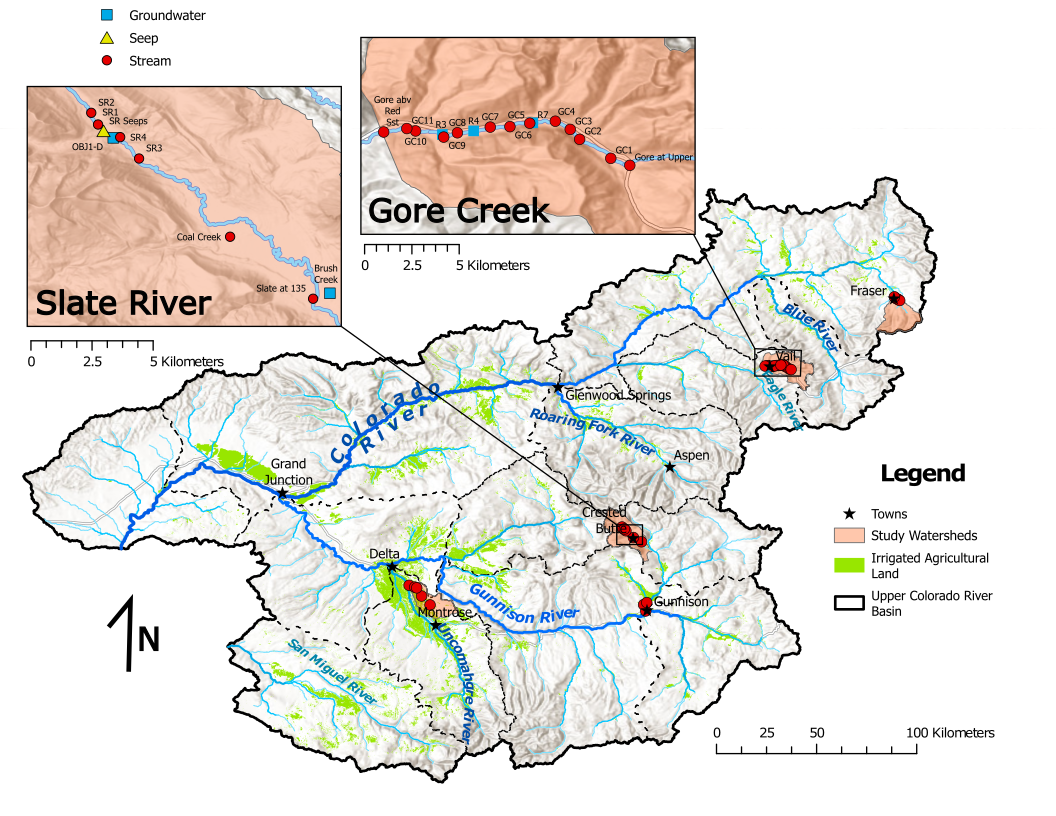
The Upper Colorado River Basin (UCOL) serves as an important source of water to millions of people, supports irrigation for agriculture, and provides aquatic habitat for a variety of species. Salinity concentrations endanger water supply in the Colorado River Basin, potentially causing hundreds of millions of dollars in annual economic damage because of corrosion of infrastructure, water treatment costs, and reduced agricultural yields. Because of the importance of the UCOL in governing downstream water use and availability, the U.S. Geological Survey (USGS) is conducting integrated studies of groundwater discharge to streams in multiple subbasins within the UCOL (map below). This study is operated through the USGS Next Generation Water Observing Systems (NGWOS) program and contributes to USGS monitoring and data analyses focused on the complete water cycle within the UCOL.
Media
Sources/Usage: Public Domain. View Media Details
There are multiple objectives for the project:
- Define spatial and temporal variability of groundwater discharge to streams using multiple methodologies, including geochemical tracers, specific conductance, groundwater age, and water temperature.
- Quantify changes in water budget of the UCOL based on repeated groundwater age evaluation and changes in groundwater levels.
- Develop tools and methodologies for widespread use in mapping groundwater discharge zones and understanding water budget changes.
Media
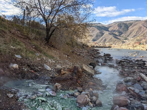
Geothermal groundwater discharge is a substantial source of salinity to the Colorado River. USGS scientists sample geothermal springs to learn more about the age of groundwater and the rock units that interact with groundwater.
Sources/Usage: Public Domain. View Media Details
Credit: Connor Newman, USGS
Media
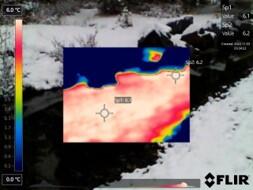
Because of thermal contrasts between inflowing groundwater and streams, USGS scientists use thermal infrared cameras to identify zones of groundwater discharge, as seen in this photograph.
Sources/Usage: Public Domain. View Media Details
Results
Media
Sources/Usage: Public Domain. View Media Details
Credit: Connor Newman, USGS
Results of detailed mapping of groundwater and surface-water interactions indicated that zones of groundwater discharge to streams in the UCOL are typically limited in spatial extent and are small areas of the stream corridor that may have outsized influence on salinity and stream water temperature. Groundwater discharge zones in both headwater mountain subbasins along the main stem of the Colorado River through Glenwood Springs, were generally 10s to 100s of meters long (Newman and others, 2024). These results indicated that studies of groundwater and surface-water interaction can account for a variety of spatial scales when monitoring groundwater discharge to streams.
Environmental tracers and groundwater age indicators illustrate that most groundwater in the UCOL is on the order of tens of years old, but areas exist with substantially older groundwater (up to tens of thousands of years old; Paschke and others, 2022). Monitoring environmental tracers through time could indicate if groundwater wells and springs have changing groundwater ages. Changes in groundwater age may provide direct indications of transience in the water budget, providing important information related to groundwater sustainability in the area.
Monitoring of groundwater recharge and discharge processes is ongoing across the UCOL, with the goal of continuing to provide stakeholders with data and actionable information.

Regional Water Availability Assessment: Upper Colorado River Basin
Regional Water Availability Assessments are scientific assessments of water availability in different hydrologic regions across the Nation. In the Upper Colorado River Basin, the USGS will conduct a focused assessment of how snowpack and snowmelt influence hydrology and water quality, and an integrated and comprehensive assessment of multiple water quantity, quality and use factors.

Thermal infrared imaging of groundwater discharge
Because of thermal contrasts between inflowing groundwater and streams, USGS scientists use thermal infrared cameras to identify zones of groundwater discharge, as seen in this photograph.

Geothermal springs along Colorado River
Geothermal groundwater discharge is a substantial source of salinity to the Colorado River. USGS scientists sample geothermal springs to learn more about the age of groundwater and the rock units that interact with groundwater.
Geothermal groundwater discharge is a substantial source of salinity to the Colorado River. USGS scientists sample geothermal springs to learn more about the age of groundwater and the rock units that interact with groundwater.

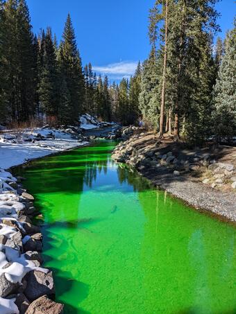
Dye tracer study of the Slate River
USGS scientists injected a non-toxic fluorescent dye into the Slate River to identify zones of groundwater discharge.
USGS scientists injected a non-toxic fluorescent dye into the Slate River to identify zones of groundwater discharge.
The Upper Colorado River Basin (UCOL) serves as an important source of water to millions of people, supports irrigation for agriculture, and provides aquatic habitat for a variety of species. Salinity concentrations endanger water supply in the Colorado River Basin, potentially causing hundreds of millions of dollars in annual economic damage because of corrosion of infrastructure, water treatment costs, and reduced agricultural yields. Because of the importance of the UCOL in governing downstream water use and availability, the U.S. Geological Survey (USGS) is conducting integrated studies of groundwater discharge to streams in multiple subbasins within the UCOL (map below). This study is operated through the USGS Next Generation Water Observing Systems (NGWOS) program and contributes to USGS monitoring and data analyses focused on the complete water cycle within the UCOL.
Media
Sources/Usage: Public Domain. View Media Details
There are multiple objectives for the project:
- Define spatial and temporal variability of groundwater discharge to streams using multiple methodologies, including geochemical tracers, specific conductance, groundwater age, and water temperature.
- Quantify changes in water budget of the UCOL based on repeated groundwater age evaluation and changes in groundwater levels.
- Develop tools and methodologies for widespread use in mapping groundwater discharge zones and understanding water budget changes.
Media
Geothermal groundwater discharge is a substantial source of salinity to the Colorado River. USGS scientists sample geothermal springs to learn more about the age of groundwater and the rock units that interact with groundwater.
Sources/Usage: Public Domain. View Media Details
Credit: Connor Newman, USGS
Media
Because of thermal contrasts between inflowing groundwater and streams, USGS scientists use thermal infrared cameras to identify zones of groundwater discharge, as seen in this photograph.
Sources/Usage: Public Domain. View Media Details
Results
Media
Sources/Usage: Public Domain. View Media Details
Credit: Connor Newman, USGS
Results of detailed mapping of groundwater and surface-water interactions indicated that zones of groundwater discharge to streams in the UCOL are typically limited in spatial extent and are small areas of the stream corridor that may have outsized influence on salinity and stream water temperature. Groundwater discharge zones in both headwater mountain subbasins along the main stem of the Colorado River through Glenwood Springs, were generally 10s to 100s of meters long (Newman and others, 2024). These results indicated that studies of groundwater and surface-water interaction can account for a variety of spatial scales when monitoring groundwater discharge to streams.
Environmental tracers and groundwater age indicators illustrate that most groundwater in the UCOL is on the order of tens of years old, but areas exist with substantially older groundwater (up to tens of thousands of years old; Paschke and others, 2022). Monitoring environmental tracers through time could indicate if groundwater wells and springs have changing groundwater ages. Changes in groundwater age may provide direct indications of transience in the water budget, providing important information related to groundwater sustainability in the area.
Monitoring of groundwater recharge and discharge processes is ongoing across the UCOL, with the goal of continuing to provide stakeholders with data and actionable information.
Regional Water Availability Assessment: Upper Colorado River Basin
Regional Water Availability Assessments are scientific assessments of water availability in different hydrologic regions across the Nation. In the Upper Colorado River Basin, the USGS will conduct a focused assessment of how snowpack and snowmelt influence hydrology and water quality, and an integrated and comprehensive assessment of multiple water quantity, quality and use factors.
Thermal infrared imaging of groundwater discharge
Because of thermal contrasts between inflowing groundwater and streams, USGS scientists use thermal infrared cameras to identify zones of groundwater discharge, as seen in this photograph.
Because of thermal contrasts between inflowing groundwater and streams, USGS scientists use thermal infrared cameras to identify zones of groundwater discharge, as seen in this photograph.
Geothermal springs along Colorado River
Geothermal groundwater discharge is a substantial source of salinity to the Colorado River. USGS scientists sample geothermal springs to learn more about the age of groundwater and the rock units that interact with groundwater.
Geothermal groundwater discharge is a substantial source of salinity to the Colorado River. USGS scientists sample geothermal springs to learn more about the age of groundwater and the rock units that interact with groundwater.
Dye tracer study of the Slate River
USGS scientists injected a non-toxic fluorescent dye into the Slate River to identify zones of groundwater discharge.
USGS scientists injected a non-toxic fluorescent dye into the Slate River to identify zones of groundwater discharge.