
The namesake of the City of Steamboat Springs was once a geyser. Now the spring upwells into a large pool before flowing out to the Yampa River.
Connor Patrick Newman (Former Employee)
Science and Products
Quantifying groundwater recharge and discharge dynamics in the Upper Colorado River Basin
The Upper Colorado River Basin (UCOL) serves as an important source of water to millions of people, supports irrigation for agriculture, and provides aquatic habitat for a variety of species. Salinity concentrations endanger water supply in the Colorado River Basin, potentially causing hundreds of millions of dollars in annual economic damage because of corrosion of infrastructure, water treatment...

Making water tracing rock solid: national, geologic map-based visualization of USGS water strontium isotope data
Nationwide data source for USGS water strontium isotopes for hydrologic, ecologic, and forensic studies

Isotopic and environmental tracers for improved understanding of geochemical and hydrologic processes occurring near flooded mine workings
Draining mine tunnels contribute metals and acidity to streams throughout the western United States. One remediation strategy that is increasing in usage is the emplacement of hydraulic bulkheads to impound water within the subsurface. Potential secondary effects of bulkhead usage are difficult to quantify however because of the inherent complexity of many mountain hydrologic systems. In...

Data supporting management of thermal springs –Steamboat Springs, Colorado
The U.S. Geological Survey (USGS), in cooperation with the city of Steamboat Springs and the Tread of Pioneers Museum, is undertaking a geologic, hydrologic, and geochemical study to better understand the sources of water to hot springs and the possible effects of land use change and human activities on the chemistry and sustainability of springs.

Hydrology of an Artesian Aquifer near Manitou Springs, Colorado
The area surrounding Manitou Springs, Colorado is host to numerous bedrock springs, which help to support the local economy through tourist visitation. Although many springs previously flowed directly to the surface, most of the “springs” in the area are now more strictly classified as flowing artesian wells completed in the Manitou Formation, a cavernous intermixed limestone and dolomite, which...

Hydrology of and potential for groundwater storage in the alluvial aquifer in the Wet Mountain Valley, Colorado
Hydrologic analysis of the alluvial aquifer in the Wet Mountain Valley has been undertaken using synoptic streamflow and groundwater-level elevation measurements, aquifer tests, water-quality sampling and data analysis, and numerical groundwater-flow modeling. These datasets together provide an encompassing view of the interconnected water resources in the area and allow for quantitative...

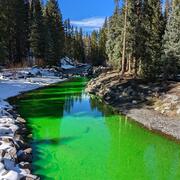
Yampa River and Steamboat Spring Outflow
The namesake of the City of Steamboat Springs was once a geyser. Now the spring upwells into a large pool before flowing out to the Yampa River.

Infrared image of Narcissus Spring Outflow
USGS hydrologists use thermal infrared (IR) imagery to evaluate the distribution of warm and hot springs near the Yampa River. Numerous diffuse springs discharge near the river, and IR imagery is useful as a screening tool to pinpoint points of discharge to be sampled for water quality.
USGS hydrologists use thermal infrared (IR) imagery to evaluate the distribution of warm and hot springs near the Yampa River. Numerous diffuse springs discharge near the river, and IR imagery is useful as a screening tool to pinpoint points of discharge to be sampled for water quality.

Iron Spring outflow at Fountain Creek near Manitou Springs, Colorado
Iron Spring outflow at Fountain Creek near Manitou Springs, ColoradoSprings discharging from the artesian aquifer are commonly supersaturated with minerals. In this photo at Iron Spring a small mound of iron hydroxides is forming below where the spring outflows to Fountain Creek.

Fountain Creek near Manitou Spring, Colorado
Image of a streamflow measurement site on Fountain Creek near Manitou Springs, Colorado.
Image of a streamflow measurement site on Fountain Creek near Manitou Springs, Colorado.

North Taylor Creek, Wet Mountain Valley, Colorado
Image of North Taylor Creek in Wet Mountain Valley, Colorado prior to completion of a surface-water discharge measurement.
Image of North Taylor Creek in Wet Mountain Valley, Colorado prior to completion of a surface-water discharge measurement.

Aquifer testing in Wet Mountain Valley, Colorado
Photo of equipment for slug test at aquifer testing site in Colorado. The Rocky Mountains are visible in the background.
Photo of equipment for slug test at aquifer testing site in Colorado. The Rocky Mountains are visible in the background.
Science and Products
Quantifying groundwater recharge and discharge dynamics in the Upper Colorado River Basin
The Upper Colorado River Basin (UCOL) serves as an important source of water to millions of people, supports irrigation for agriculture, and provides aquatic habitat for a variety of species. Salinity concentrations endanger water supply in the Colorado River Basin, potentially causing hundreds of millions of dollars in annual economic damage because of corrosion of infrastructure, water treatment...
Making water tracing rock solid: national, geologic map-based visualization of USGS water strontium isotope data
Nationwide data source for USGS water strontium isotopes for hydrologic, ecologic, and forensic studies
Isotopic and environmental tracers for improved understanding of geochemical and hydrologic processes occurring near flooded mine workings
Draining mine tunnels contribute metals and acidity to streams throughout the western United States. One remediation strategy that is increasing in usage is the emplacement of hydraulic bulkheads to impound water within the subsurface. Potential secondary effects of bulkhead usage are difficult to quantify however because of the inherent complexity of many mountain hydrologic systems. In...
Data supporting management of thermal springs –Steamboat Springs, Colorado
The U.S. Geological Survey (USGS), in cooperation with the city of Steamboat Springs and the Tread of Pioneers Museum, is undertaking a geologic, hydrologic, and geochemical study to better understand the sources of water to hot springs and the possible effects of land use change and human activities on the chemistry and sustainability of springs.
Hydrology of an Artesian Aquifer near Manitou Springs, Colorado
The area surrounding Manitou Springs, Colorado is host to numerous bedrock springs, which help to support the local economy through tourist visitation. Although many springs previously flowed directly to the surface, most of the “springs” in the area are now more strictly classified as flowing artesian wells completed in the Manitou Formation, a cavernous intermixed limestone and dolomite, which...
Hydrology of and potential for groundwater storage in the alluvial aquifer in the Wet Mountain Valley, Colorado
Hydrologic analysis of the alluvial aquifer in the Wet Mountain Valley has been undertaken using synoptic streamflow and groundwater-level elevation measurements, aquifer tests, water-quality sampling and data analysis, and numerical groundwater-flow modeling. These datasets together provide an encompassing view of the interconnected water resources in the area and allow for quantitative...
Yampa River and Steamboat Spring Outflow
The namesake of the City of Steamboat Springs was once a geyser. Now the spring upwells into a large pool before flowing out to the Yampa River.
The namesake of the City of Steamboat Springs was once a geyser. Now the spring upwells into a large pool before flowing out to the Yampa River.
Infrared image of Narcissus Spring Outflow
USGS hydrologists use thermal infrared (IR) imagery to evaluate the distribution of warm and hot springs near the Yampa River. Numerous diffuse springs discharge near the river, and IR imagery is useful as a screening tool to pinpoint points of discharge to be sampled for water quality.
USGS hydrologists use thermal infrared (IR) imagery to evaluate the distribution of warm and hot springs near the Yampa River. Numerous diffuse springs discharge near the river, and IR imagery is useful as a screening tool to pinpoint points of discharge to be sampled for water quality.
Iron Spring outflow at Fountain Creek near Manitou Springs, Colorado
Iron Spring outflow at Fountain Creek near Manitou Springs, ColoradoSprings discharging from the artesian aquifer are commonly supersaturated with minerals. In this photo at Iron Spring a small mound of iron hydroxides is forming below where the spring outflows to Fountain Creek.
Fountain Creek near Manitou Spring, Colorado
Image of a streamflow measurement site on Fountain Creek near Manitou Springs, Colorado.
Image of a streamflow measurement site on Fountain Creek near Manitou Springs, Colorado.
North Taylor Creek, Wet Mountain Valley, Colorado
Image of North Taylor Creek in Wet Mountain Valley, Colorado prior to completion of a surface-water discharge measurement.
Image of North Taylor Creek in Wet Mountain Valley, Colorado prior to completion of a surface-water discharge measurement.
Aquifer testing in Wet Mountain Valley, Colorado
Photo of equipment for slug test at aquifer testing site in Colorado. The Rocky Mountains are visible in the background.
Photo of equipment for slug test at aquifer testing site in Colorado. The Rocky Mountains are visible in the background.
*Disclaimer: Listing outside positions with professional scientific organizations on this Staff Profile are for informational purposes only and do not constitute an endorsement of those professional scientific organizations or their activities by the USGS, Department of the Interior, or U.S. Government