
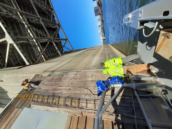
Hydrologic technicians survey the Willamette River at Portland’s streamflow gage datum. Every streamgage measures water levels (gage height) relative to a datum, a fixed elevation chosen to ensure consistent, long-term measurements.
Measuring Willamette River streamflow in Portland
Active
By Oregon Water Science Center
August 22, 2025
Learn about one of Oregon's most relied upon streamflow gages.
In 1972, USGS began measuring streamflow (discharge) of the Willamette River in Portland. Streamflow is a fundamental measurement for the Nation’s waterways. It’s used to understand water availability, manage floods, support navigation, and assess ecosystem health. The Willamette River’s flow is regulated by many upstream reservoirs and is significantly affected by ocean tides.
Media
Sources/Usage: Public Domain. View Media Details
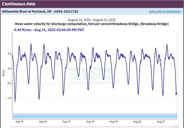
Due to the complexity introduced by ocean tides, technicians use the index-velocity method to calculate the river’s flow. When the water level in the Columbia River rises (from increased flow due to snowmelt/rainfall or from Pacific Ocean tides), it can briefly slow or reverse the Willamette’s flow, causing negative velocity readings — meaning some water is moving upstream for a short time.
The index-velocity method combines two types of measurements:
- Velocity: An instrument on the Broadway Bridge uses sound waves to measure how fast the water is moving at a specific point in the channel.
- Gage height (stage): A sensor at the Morrison Bridge records the water level, which is used to calculate the cross-sectional area of the river.
By multiplying the river’s mean velocity by its cross-sectional area (determined using the gage height), USGS computes discharge — the total volume of water passing a point per unit of time. This method is especially useful in large, tidally influenced rivers like the lower Willamette, where the relationship between stage and flow changes with tides and other factors.
The data page for the Willamette at Portland often has the most visits per month out of all Oregon streamgages. The data is relied upon by water resource managers, environmental consultants and engineers, local and federal government agencies, universities, recreational users, the shipping industry and more.
The Willamette River at Portland is a Federal Priority Streamgage (FPS). These streamgages are important for meeting specific long-term needs of the Nation. Established in 1999, the FPS Network has thousands of monitoring locations across the United States.
The Importance of Long-Term Data
Long-term streamflow and water-quality data provide a baseline for understanding natural conditions, detecting trends, and evaluating the effects of human activities and climate. By tracking changes over years and decades, scientists can distinguish short-term fluctuations from meaningful patterns, inform resource management, guide policy decisions, and help protect aquatic ecosystems and public health.
Historic observations
Media
Sources/Usage: Public Domain. View Media Details
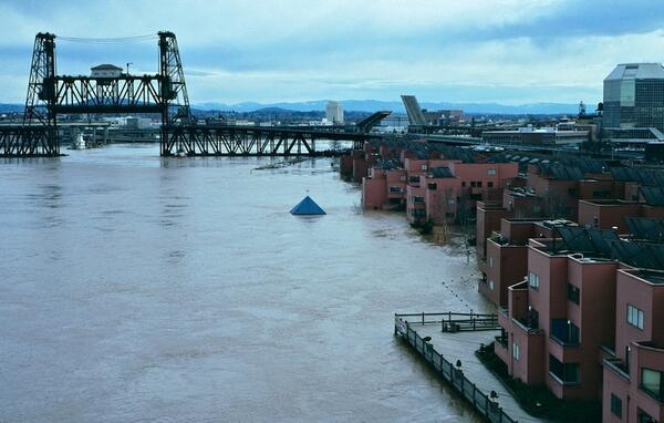
During the USGS’s period of record (1972 – current) the highest flow volume recorded was 420,000 cubic feet per second on February 9, 1996, at a gage height of 27.74 feet. During this flood, rivers in the Willamette Valley reached record highs due to a series of unusual weather events.
The lowest flow volume recorded by the USGS was 4,200 cubic feet per second on July 10, 1978.
Monitoring of the Willamette River can be traced back to Portland’s early days. The National Weather Service began recording gage height on the Willamette way back in 1879 - when the original Morrison Bridge was still in place. On June 7, 1894, the river's gage height reached 33 feet! While no flow volumes were measured this early—and with no dams in place to hold back floodwaters—one can imagine that this event rivaled the 1996 flood.
Prior to the dams, the basin experienced major floods during wet water years, and there are many fascinating records of floods throughout written histories by American settlers and oral history of native peoples. The Great Flood of 1861 is credited by historians as the largest flood in the written history of the Willamette River.
Photos taken during field work at this location.
Willamette at Portland streamgage maintenance
Hydrologic technicians survey the Willamette River at Portland’s streamflow gage datum. Every streamgage measures water levels (gage height) relative to a datum, a fixed elevation chosen to ensure consistent, long-term measurements.
Learn about one of Oregon's most relied upon streamflow gages.
In 1972, USGS began measuring streamflow (discharge) of the Willamette River in Portland. Streamflow is a fundamental measurement for the Nation’s waterways. It’s used to understand water availability, manage floods, support navigation, and assess ecosystem health. The Willamette River’s flow is regulated by many upstream reservoirs and is significantly affected by ocean tides.
Media
Sources/Usage: Public Domain. View Media Details
Due to the complexity introduced by ocean tides, technicians use the index-velocity method to calculate the river’s flow. When the water level in the Columbia River rises (from increased flow due to snowmelt/rainfall or from Pacific Ocean tides), it can briefly slow or reverse the Willamette’s flow, causing negative velocity readings — meaning some water is moving upstream for a short time.
The index-velocity method combines two types of measurements:
- Velocity: An instrument on the Broadway Bridge uses sound waves to measure how fast the water is moving at a specific point in the channel.
- Gage height (stage): A sensor at the Morrison Bridge records the water level, which is used to calculate the cross-sectional area of the river.
By multiplying the river’s mean velocity by its cross-sectional area (determined using the gage height), USGS computes discharge — the total volume of water passing a point per unit of time. This method is especially useful in large, tidally influenced rivers like the lower Willamette, where the relationship between stage and flow changes with tides and other factors.
The data page for the Willamette at Portland often has the most visits per month out of all Oregon streamgages. The data is relied upon by water resource managers, environmental consultants and engineers, local and federal government agencies, universities, recreational users, the shipping industry and more.
The Willamette River at Portland is a Federal Priority Streamgage (FPS). These streamgages are important for meeting specific long-term needs of the Nation. Established in 1999, the FPS Network has thousands of monitoring locations across the United States.
The Importance of Long-Term Data
Long-term streamflow and water-quality data provide a baseline for understanding natural conditions, detecting trends, and evaluating the effects of human activities and climate. By tracking changes over years and decades, scientists can distinguish short-term fluctuations from meaningful patterns, inform resource management, guide policy decisions, and help protect aquatic ecosystems and public health.
Historic observations
Media
Sources/Usage: Public Domain. View Media Details
During the USGS’s period of record (1972 – current) the highest flow volume recorded was 420,000 cubic feet per second on February 9, 1996, at a gage height of 27.74 feet. During this flood, rivers in the Willamette Valley reached record highs due to a series of unusual weather events.
The lowest flow volume recorded by the USGS was 4,200 cubic feet per second on July 10, 1978.
Monitoring of the Willamette River can be traced back to Portland’s early days. The National Weather Service began recording gage height on the Willamette way back in 1879 - when the original Morrison Bridge was still in place. On June 7, 1894, the river's gage height reached 33 feet! While no flow volumes were measured this early—and with no dams in place to hold back floodwaters—one can imagine that this event rivaled the 1996 flood.
Prior to the dams, the basin experienced major floods during wet water years, and there are many fascinating records of floods throughout written histories by American settlers and oral history of native peoples. The Great Flood of 1861 is credited by historians as the largest flood in the written history of the Willamette River.
Photos taken during field work at this location.
Willamette at Portland streamgage maintenance
Hydrologic technicians survey the Willamette River at Portland’s streamflow gage datum. Every streamgage measures water levels (gage height) relative to a datum, a fixed elevation chosen to ensure consistent, long-term measurements.
Hydrologic technicians survey the Willamette River at Portland’s streamflow gage datum. Every streamgage measures water levels (gage height) relative to a datum, a fixed elevation chosen to ensure consistent, long-term measurements.