
Marc A Stewart
Marc Stewart is the Deputy Director for Data at the USGS Oregon Water Science Center.
Marc transferred from the National Park Service and started his USGS career as a Hydrologic Technician in 1998 for the Miami Subdistrict, Florida. In 2005, he transferred to the USGS Oregon Water Science Center (ORWSC) in Central Point, Oregon, where he worked as a Supervisory Hydrologic Technician specializing in hydroacoustic methods for data collection. In 2014, Marc took over as the lead of the ORWSC Quality Assurance Team as a Hydrologist and worked on various surface-water data collection projects, sediment studies, and Quality assurance needs for the Hydrologic Data Section. He became the Deputy Director for Data in 2023.
Science and Products
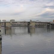
Measuring Willamette River streamflow in Portland
Learn about one of Oregon's most relied upon streamflow gages.

New gages for understanding surface water availability and spring Chinook salmon habitat in the Willamette Basin
Learn about our new streamgages in the Williamette River Basin.

Integrated Water Science Basins: Willamette River
The Willamette River Basin reflects the conflicting water demands between humans and ecosystems—particularly salmon— and the challenge resource managers face throughout the Pacific Northwest.

ORWSC Field Methods Training Workshop
Announcing the ORWSC's "Training for Advancement in Hydrologic Data Processing and Technical Field Skills" from Monday, April 30, 2018 to Thursday, May 3, 2018, at Camp Rilea, Oregon.
Science and Products
Measuring Willamette River streamflow in Portland
Learn about one of Oregon's most relied upon streamflow gages.
New gages for understanding surface water availability and spring Chinook salmon habitat in the Willamette Basin
Learn about our new streamgages in the Williamette River Basin.
Integrated Water Science Basins: Willamette River
The Willamette River Basin reflects the conflicting water demands between humans and ecosystems—particularly salmon— and the challenge resource managers face throughout the Pacific Northwest.
ORWSC Field Methods Training Workshop
Announcing the ORWSC's "Training for Advancement in Hydrologic Data Processing and Technical Field Skills" from Monday, April 30, 2018 to Thursday, May 3, 2018, at Camp Rilea, Oregon.