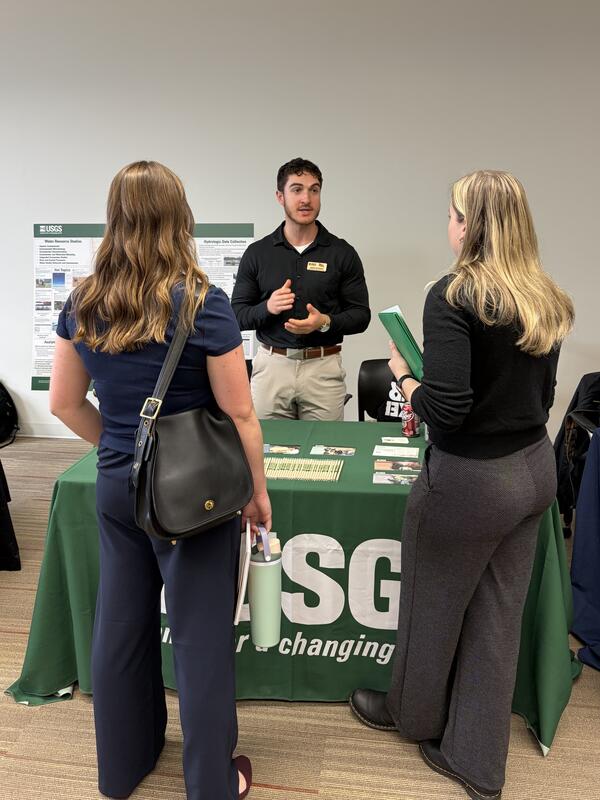
U.S. flag

An official website of the United States government

Multimedia

Our multimedia gallery represents a collection of high-quality images, videos, webcams, posters, presentations, and documents produced by the Upper Midwest Water Science Center.

Images

Milwaukee Harbor in foreground with Discovery World building and other tall buildings in background
Milwaukee Harbor and Discovery World on an early autumn day

Milwaukee Harbor in foreground with Discovery World building featured, on an early autumn day.

Watercolor and ink painting depicting117 species of plants near a mine site in northern Arizona
Floral Heritage
Floral Heritage
Floral Heritage

Painting (watercolor and ink) depicting the 117 species of plants found in and around a mine site that are utilized by the tribal community in northern Arizona.

Painting (watercolor and ink) depicting the 117 species of plants found in and around a mine site that are utilized by the tribal community in northern Arizona.

A bright orange acoustic Doppler current profiler takes a streamflow measurement in a flooded stream
ADCP measurement at 04087088 Underwood Creek after flooding

An acoustic Doppler current profiler (ADCP) device takes a streamflow measurement at streamgage 04087088 Underwood Creek, near Milwaukee, Wisconsin after a flood event in August 2025.

An acoustic Doppler current profiler (ADCP) device takes a streamflow measurement at streamgage 04087088 Underwood Creek, near Milwaukee, Wisconsin after a flood event in August 2025.

Brown floodwaters swirling in foreground with green trees in background
Flooding at streamgage 04087120 Menomonee River in Wauwatosa, Wisconsin

Floodwaters swirl in the foreground and trees peek up in the background, during flooding of the Menomonee River in Wauwasota, Wisconsin in August 2025, at streamgage 04087120.

https://waterdata.usgs.gov/monitoring-location/USGS-04087120/

Man standing on boat with large bridge in background
Scientist conducting field work on the Detroit River

Physical scientist Brent Heerspink conducts sampling on the Detroit River with the Gordie Howe International Bridge in the background.

Gouache painting depicting the Blue Mesa Reservoir during a year of low precipitation totals
Blue Mesa Reservoir in Dry Conditions

Painting (gouache painting) depicting the Blue Mesa Reservoir during a year of low precipitation totals and the resulting cyanobacteria distribution.

Painting (gouache painting) depicting the Blue Mesa Reservoir during a year of low precipitation totals and the resulting cyanobacteria distribution.

Videos

Spawning sockeye salmon in Izembek National Wildlife Refuge, Alaska

USGS Upper Midwest Water Science Center hydrologist Laura Hubbard navigates between hundreds of spawning sockeye salmon as she filters water to detect avian influenza virus at Izembek National Wildlife Refuge, Alaska.

USGS Upper Midwest Water Science Center hydrologist Laura Hubbard navigates between hundreds of spawning sockeye salmon as she filters water to detect avian influenza virus at Izembek National Wildlife Refuge, Alaska.

Helicopter towing large hoop over snow covered ground, technician for scale Helicopter towing large hoop over snow covered ground, technician for scale
Southern Wisconsin Airborne Electromagnetic Survey 2022

Low-flying helicopter with geophysical equipment loop deployed below it via slingload. In March 2022, a helicopter carried an airborne electromagnetic induction sensor over parts of southeast and southwest Wisconsin as part of a USGS study to map the aquifers in the region.

Low-flying helicopter with geophysical equipment loop deployed below it via slingload. In March 2022, a helicopter carried an airborne electromagnetic induction sensor over parts of southeast and southwest Wisconsin as part of a USGS study to map the aquifers in the region.

Geophysical survey hoop resting on snowy ground Geophysical survey hoop resting on snowy ground
Northeast Wisconsin Airborne Electromagnetic Survey 2021 - Panoramic view of equipment on ground

Geophysical equipment loop for electromagnetic survey on ground prior to liftoff by helicopter. In January 2021 a helicopter carried an airborne electromagnetic induction sensor over parts of northeastern Wisconsin as part of a USGS study to map the aquifers in the region.

Geophysical equipment loop for electromagnetic survey on ground prior to liftoff by helicopter. In January 2021 a helicopter carried an airborne electromagnetic induction sensor over parts of northeastern Wisconsin as part of a USGS study to map the aquifers in the region.

Monitoring Stormwater and Green Infrastructure (Gary City Hall, Ind.)

This time-lapse video shows the construction of the new Gary City Hall parking lot and rain garden in Gary, Indiana. The City of Gary is utilizing green infrastructure in their redevelopment projects in the hopes of reducing the amount stormwater runoff that enters their storm-sewer system and, eventually, Lake Michigan.

This time-lapse video shows the construction of the new Gary City Hall parking lot and rain garden in Gary, Indiana. The City of Gary is utilizing green infrastructure in their redevelopment projects in the hopes of reducing the amount stormwater runoff that enters their storm-sewer system and, eventually, Lake Michigan.

Edge-of-Field Monitoring Using Depth-Integrated Sample Arm (DISA)

During edge-of-field monitoring of an agricultural field runoff event, a depth-integrated sample arm (DISA) is used to take a water sample at the same time a traditional water sample is taken from an intake located at the bottom of the H-flume exit, where the water is assumed to be completely mixed.

During edge-of-field monitoring of an agricultural field runoff event, a depth-integrated sample arm (DISA) is used to take a water sample at the same time a traditional water sample is taken from an intake located at the bottom of the H-flume exit, where the water is assumed to be completely mixed.

Working Aboard the U.S. EPA's Lake Guardian Sampling for Mercury

Dave Krabbenhoft discusses working on the U.S. EPA's Lake Guardian, and the perspective he and his team have by being on board and viewing the less developed parts of the shoreline from the middle of the lake.

Dave Krabbenhoft discusses working on the U.S. EPA's Lake Guardian, and the perspective he and his team have by being on board and viewing the less developed parts of the shoreline from the middle of the lake.

Webcams

View of shallow river from side
Underwood Creek near Elm Grove Soccer Field SIDEVIEW

Webcam at Underwood Creek near Elm Grove, Wisconsin, Soccer Field, Fish Camera SIDEVIEW.

View of shallow stream from above
Underwood Creek near Elm Grove Soccer Field DOWN LOOKING

Webcam at Underwood Creek near Elm Grove, Wisconsin, Soccer Field, Fish Camera DOWN LOOKING. 

View of shallow stream from above
Underwood Creek at Wauwatosa FISH CAMERA LOOKING DOWN

Underwood Creek at Wauwatosa, Wisconsin, FISH CAMERA LOOKING DOWN.

Streamgage Underwood Creek at Wauwatosa, WI - 04087088 Underwood Creek at Wauwatosa, WI - USGS Water Data for the Nation

Was this page helpful?