
USGS Hawaiian Volcano Observatory scientists completed a helicopter overflight of the Kīlauea summit on March 31, 2026, during which they captured this overview photo of the eruptive vents in western Halema‘uma‘u crater.
Images
Hawaiian Volcano Observatory images of eruptive activity, field work, and more.
Filter Total Items: 3867
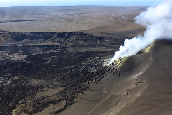
March 31, 2026 — Overview of eruptive vents
USGS Hawaiian Volcano Observatory scientists completed a helicopter overflight of the Kīlauea summit on March 31, 2026, during which they captured this overview photo of the eruptive vents in western Halema‘uma‘u crater.
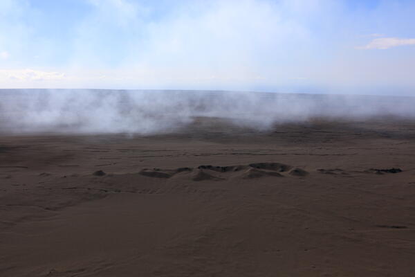
March 31, 2026 — Tephra-blanketed Cone Peak
The tephra deposit from the ongoing Kīlauea summit eruption has dramatically changed the landscape in the predominant downwind direction (southwest) of Halema‘uma‘u crater.
The tephra deposit from the ongoing Kīlauea summit eruption has dramatically changed the landscape in the predominant downwind direction (southwest) of Halema‘uma‘u crater.
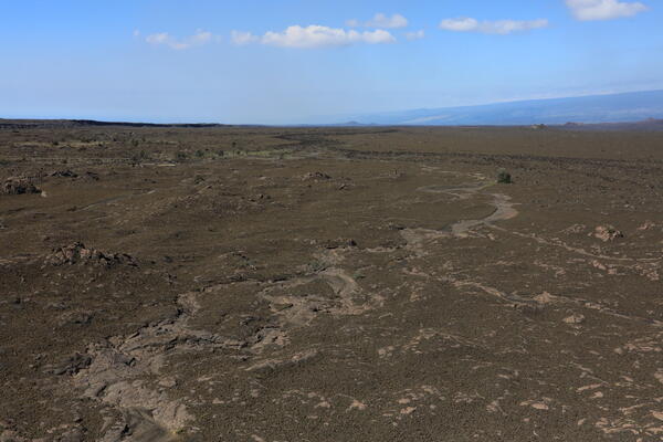
March 31, 2026 — Erosion of tephra deposit
Despite the expansive nature of the tephra deposit from the ongoing Kīlauea summit eruption, recent rains from Kona low storms have taken their toll. In this photo captured during the USGS Hawaiian Volcano Observatory helicopter overflight on March 31, an ephemeral stream has eroded through the deposit to expose the much older lava flows underneath.
Despite the expansive nature of the tephra deposit from the ongoing Kīlauea summit eruption, recent rains from Kona low storms have taken their toll. In this photo captured during the USGS Hawaiian Volcano Observatory helicopter overflight on March 31, an ephemeral stream has eroded through the deposit to expose the much older lava flows underneath.
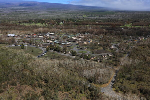
March 31, 2026 — Tephra around Kīlauea Military Camp
March 31, 2026 — Tephra around Kīlauea Military CampAround Hawai‘i Volcanoes National Park, cleanup efforts continue following the tephra fall that occurred during Kīlauea summit eruption episode 43 on March 10.
March 31, 2026 — Tephra around Kīlauea Military Camp
March 31, 2026 — Tephra around Kīlauea Military CampAround Hawai‘i Volcanoes National Park, cleanup efforts continue following the tephra fall that occurred during Kīlauea summit eruption episode 43 on March 10.
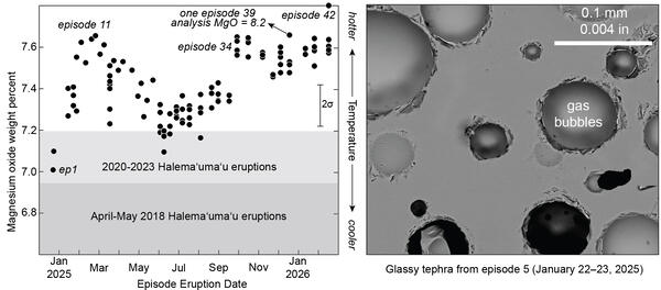
Kīlauea sample geochemistry 2018-2026 and microscope image of glass bubbles
Kīlauea sample geochemistry 2018-2026 and microscope image of glass bubblesLeft: Kīlauea tephra glass magnesium oxide for the ongoing summit fountaining eruption (black circles) compared to the ranges of glass magnesium oxide for the 2020-2023 and April–May 2018 Halema‘uma‘u eruptions. Right: Electron microscope image of glassy tephra with round gas bubbles from episode 5 that erupted from January 22–23, 2025. USGS images and data.
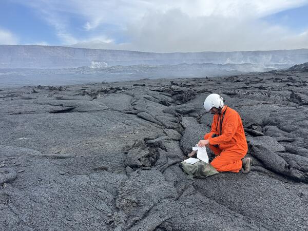
March 25, 2026 — Sampling lava flows from episode 43 at the summit of Kīlauea
March 25, 2026 — Sampling lava flows from episode 43 at the summit of KīlaueaA USGS Hawaiian Volcano Observatory geologist collects a cooled sample of episode 43 lava from the floor of Halema‘uma‘u crater, at the summit of Kīlauea. Sampling in this area, which is culturally significant to the Native Hawaiian community, is down with permission from and coordination with Hawai‘i Volcanoes National Park.
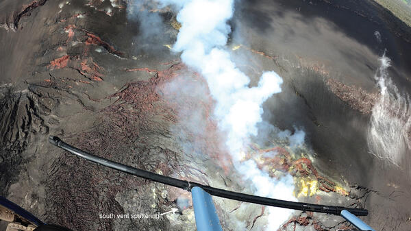
March 25, 2026 — Kīlauea summit overflight view into the south vent
March 25, 2026 — Kīlauea summit overflight view into the south ventThis vertical aerial view, taken during a USGS Hawaiian Volcano Observatory monitoring helicopter overflight on March 25, 2026, shows a small area of weak spattering deep within the south vent, at the summit of Kīlauea. The south vent and spattering (orange dot) are visible at the bottom of the photo. USGS photo by M. Patrick.
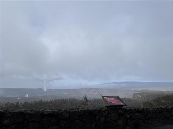
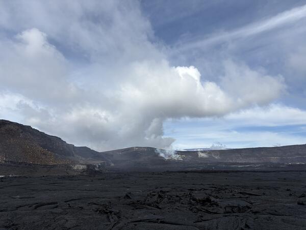
March 25, 2026 — Kīlauea caldera, Kaluapele, and Mauna Loa
March 25, 2026 — Kīlauea caldera, Kaluapele, and Mauna LoaA misty view across Kaluapele, Kīlauea summit caldera, on March 25, 2026, from the caldera rim near the Volcano House Hotel in Hawaiʻi Volcanoes National Park. The active north and south vents, on the southwest side of the caldera, are visibly degassing in this photo, following episode 43 of lava fountaining on March 10, 2026.
March 25, 2026 — View of active vents at the summit of Kīlauea
March 25, 2026 — View of active vents at the summit of KīlaueaThis photograph was taken from the eastern part of the crater floor of Halemaʻumaʻu on March 25, 2026, after episode 43 of lava fountaining that occurred in this area on March 10, 2026. The north and south vents are visible with yellow sulfur crystals decorating its surface.
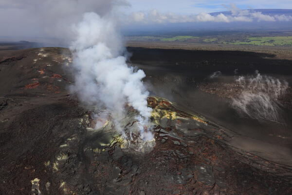
March 25, 2026 — Aerial view of the actively degassing vents at the summit of Kīlauea
March 25, 2026 — Aerial view of the actively degassing vents at the summit of KīlaueaOn March 25, 2026, U.S. Geological Survey Hawaiian Volcano Observatory staff conducted a routine helicopter overflight to collect samples from the crater floor and thermal and visual images around Halemaʻumaʻu after episode 43 that occurred on March 10, 2026.
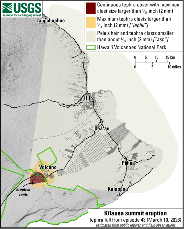
March 12, 2026—Summary map of tephra fall after episode 43 lava fountaining at the summit of Kīlauea
March 12, 2026—Summary map of tephra fall after episode 43 lava fountaining at the summit of KīlaueaThis map shows the tephra fall associated with episode 43 of Kīlauea's episodic summit eruption, on March 10, 2026. Tephra is a generic word for any material erupted by a volcano that travels through the air before landing on the ground.
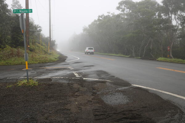
March 11, 2026 — Episode 43 fallout cleared from Highway 11 near Hawaiʻi Volcanoes National Park
March 11, 2026 — Episode 43 fallout cleared from Highway 11 near Hawaiʻi Volcanoes National ParkHighway 11 near Hawaiʻi Volcanoes National Park was affected by fallout from episode 43 lava fountains at the summit of Kīlauea on March 10, 2026. The Highway, which was nearly continuously covered with tephra, was closed on March 10 as material was cleared using heavy equipment.
March 11, 2026 — Episode 43 tephra being cleared from roadway at Kilauea Military Camp
March 11, 2026 — Episode 43 tephra being cleared from roadway at Kilauea Military CampFallout from Kīlauea episode 43 is continuing to be cleared as of the morning of March 11, 2026. This photo shows a pile of tephra that was cleared from a roadway in Kilauea Military Camp, in Hawaiʻi Volcanoes National Park, where the fallout continuously covered the ground. USGS photo.
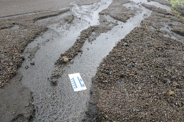
March 11, 2026 — Episode 43 tephra and rainfall
Heavy rainfall the evening of March 10-11 eroded pathways in the tephra deposit from Kīlauea episode 43 lava fountaining. This photo was taken near the Volcano Golf Course and shows the tephra fallout deposit and underlying road. USGS photo.
Heavy rainfall the evening of March 10-11 eroded pathways in the tephra deposit from Kīlauea episode 43 lava fountaining. This photo was taken near the Volcano Golf Course and shows the tephra fallout deposit and underlying road. USGS photo.
March 11, 2026 — Episode 43 tephra in Volcano Village
March 11, 2026 — Episode 43 tephra in Volcano VillageIn Volcano Village, located northeast of the eruptive vents at the summit of Kīlauea, fallout from episode 43 was less extensive than the areas to the west. This photograph shows a parking area that nearly continuously covered with tephra particles ranging up to a couple inches in diameter. USGS photo.
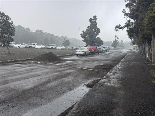
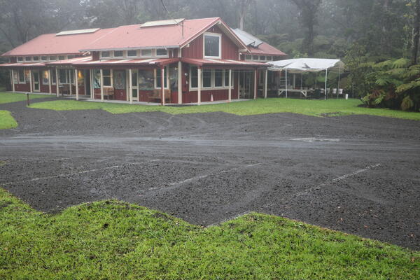
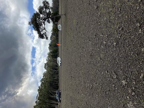
March 11, 2026 — Episode 43 fallout deposits at Volcano Golf Course
March 11, 2026 — Episode 43 fallout deposits at Volcano Golf CourseThe Volcano Golf Course, located north-northeast of the eruptive vents at the summit of Kīlauea received fallout from episode 43 lava fountains that nearly continuously covered the ground with tephra particles up to several inches in diameter. USGS photo.
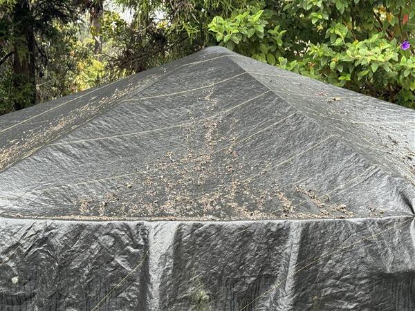
March 11, 2026 — Episode 43 fallout on a water tank cover
March 11, 2026 — Episode 43 fallout on a water tank coverTephra fallout from Kīlauea episode 43 lava fountaining accumulated on a water tank cover in Volcano Village, photographed on March 11, 2026. USGS photo.
March 11, 2026 — Episode 43 fallout on a water tank cover
March 11, 2026 — Episode 43 fallout on a water tank coverTephra fallout from Kīlauea episode 43 lava fountaining accumulated on a water tank cover in Volcano Village, photographed on March 11, 2026. USGS photo.
March 10, 2026 — Kīlauea episode 43 ashfall in Hilo
March 10, 2026 — Kīlauea episode 43 ashfall in HiloAsh fallout from Kīlauea summit lava fountaining episode 43 in Hilo just before 3 p.m. HST on March 10, 2026. USGS photo.
March 10, 2026 — Kīlauea episode 43 ashfall in Hilo
March 10, 2026 — Kīlauea episode 43 ashfall in HiloAsh fallout from Kīlauea summit lava fountaining episode 43 in Hilo just before 3 p.m. HST on March 10, 2026. USGS photo.
March 10, 2026 — Episode 43 tephra covers Kīlauea Military Camp lawn
March 10, 2026 — Episode 43 tephra covers Kīlauea Military Camp lawnNearly 5 hours into episode 43 of the ongoing eruption at Kīlauea, the lawn at Kīlauea Military Camp was covered with about an inch of tephra (2 to 3 cm). The underlying grass was barely visible. The deposit included reticulite bombs (large foamy tephra clasts) mixed in with smaller denser lapilli tephra. USGS photo by N. Deligne.
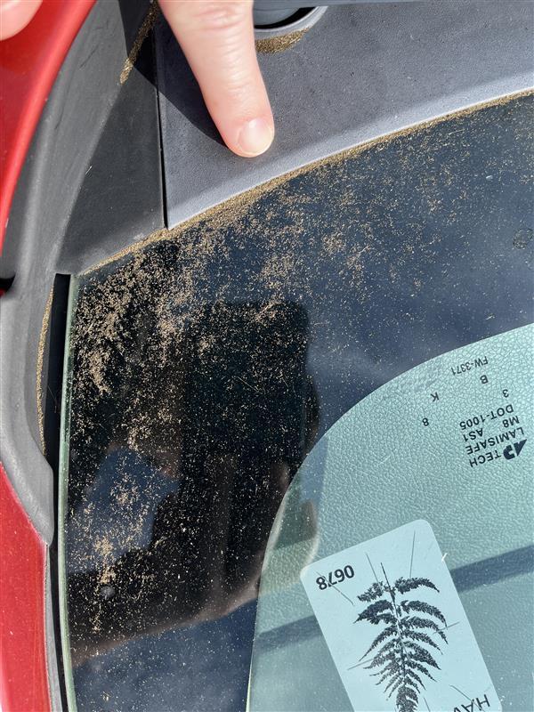
March 10, 2026 — Tephra on a building in Hawai‘i Volcanoes National Park
March 10, 2026 — Tephra on a building in Hawai‘i Volcanoes National ParkThis building within Hawai‘i Volcanoes National park is nearly 3 miles (4.7 km) east-northeast of north and south vents of the ongoing eruption of Kīlauea volcano. Tephra from episode 41 and 43 lava fountains of the ongoing Kīlauea eruption was deposited on this building. The upper portion of the roof is steeper and so falling tephra slide down it.
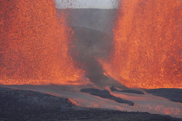
March 10, 2026 — Kīlauea episode 43 lava fountains bases
March 10, 2026 — Kīlauea episode 43 lava fountains basesThis photo shows the gap between the south (left) and north (right) lava fountains on March 10, 2026, as well as the lava channels that transport lava from the vent to the eastern crater floor. These fountains were active during episode 43 at the summit of Kīlauea. USGS photo by M. Patrick.