
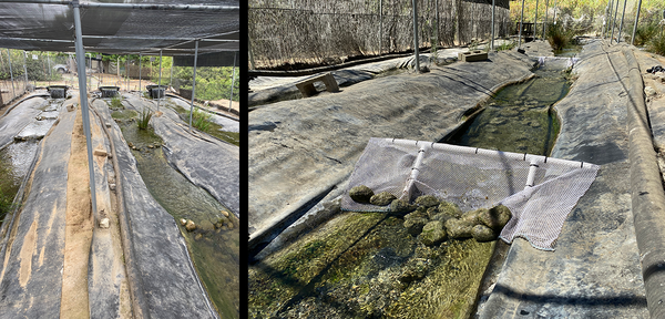
The West Sacramento Projects Office is the primary home the CAWSC Hydrodynamics and Ecology Program and also houses members of the Biogeochemistry group. These are pictures of the facility.
Steve Ackley
Steve Ackley - Public Affairs Specialist - California Water Science Center
As a science communicator at the U.S. Geological Survey (USGS), Steve Ackley has spent the past seven years bridging the gap between science and public understanding. Before joining the USGS, he spent over twenty years in high-tech marketing after starting his career as a high school English teacher.
Science and Products
Filter Total Items: 18

Monitoring and modeling soil moisture to improve runoff forecasting and drought characterization in the Feather River Basin
Drought, along with recent wildfires, have had enormous impacts downstream on water quantity and quality. These conditions have greatly impacted the agriculture and the residents of the nearby Central Valley.

USGS Participates in 2021 Orange County Youth Environmental Summit USGS Participates in 2021 Orange County Youth Environmental Summit
From April 19th through the 23rd, 2021, the USGS California Water Science Center (CAWSC) participated in the first virtual Orange County Youth Environmental Summit (YES). The award-winning program, formerly known as the Children's Water Education Festival, offers 3rd, 4th, and 5th graders opportunities for learning and engagement. Through interactive sessions, YES teaches youth that

Groundwater Ambient Monitoring & Assessment (GAMA)
The Groundwater Ambient Monitoring and Assessment Program’s Priority Basin Project (GAMA-PBP) was established by the California State Water Resources Control Board (SWRCB) in response to the Ground-Water Quality Monitoring Act of 2001 (Sections 10780-10782.3 of the California Water Code). The USGS is the technical lead for the GAMA-PBP and between 2004-2012 focused on characterizing the quality of...

USGS Participates in Earth Day Festivities on Alcatraz Island USGS Participates in Earth Day Festivities on Alcatraz Island
On April 20th, the USGS California Water Science Center (CAWSC) participated in annual Earth Day festivities on Alcatraz Island in San Francisco Bay. Involvement in the event included science presentations on the island, demonstrating the ongoing research of the USGS Estuarine Hydrodynamics and Sediment Transport team based in Sacramento.

Yucaipa Subbasin Integrated Hydrologic Model
The USGS is developing a hydrologic model of the Yucaipa Subbasin to aid in evaluating and managing the groundwater resources in the area. The study results will provide a greater understanding of the geohydrology of the subbasin, and aid in the development of a groundwater-monitoring plan, as well as in the evaluation of potential hydrologic effects of future groundwater development and...

Yucaipa Valley Hydrogeology
This study assesses the quality of water in the Yucaipa area, primarily in the Yucaipa plain. This hydrogeology study will aid local water purveyors in understanding and evaluating local resources and using those resources effectively in combination with water imported from northern California and from the adjacent San Bernardino area.

Low Intensity Chemical Dosing (LICD)
Rivers, wetlands, and agricultural operations supply natural organic material to the Sacramento-San Joaquin Delta (Delta) and the San Francisco Estuary. This natural organic matter provides many ecosystem benefits, but it also adversely affects drinking water. During drinking water treatment, chlorine added for purposes of pathogen control reacts with dissolved organic carbon (DOC) in the water to...

California Water Use
The U.S. Geological Survey's National Water-Use Information Program compiles the nation's water-use data at the county, state, and national levels. USGS five-year reports on national and state water-use estimates between 1950-2015 are posted on the web at: https://water.usgs.gov/watuse/. USGS water-use data for states and counties for 1985-2015 are available at: https://waterdata.usgs.gov/nwis/wu.

Wildfire Effect on Mercury Levels in Putah and Cache Creek Watersheds
A serious consequence of wildfires is the erosion which occurs during storm events in areas where vegetation has been burned away. In cases where such land is near a creek or stream, mercury (Hg) and other contaminants from the eroding soil can make their way into the waterways, impacting the health of fish and wildlife, and the quality of the water supply for local communities (see: USGS Fact...

Effects of Aquatic Vegetation on Water Quality and Residence Time in the Bay-Delta
The spread of invasive aquatic vegetation in the Sacramento-San Joaquin Delta is having a profound impact on the Delta’s natural habitat. The presence of these “aquatic weeds” has been shown to alter water velocity and increase water clarity, posing threats to native fish species, specifically the threatened Delta Smelt. These aquatic plants can also affect the foodweb by altering nutrient...

Temecula Hydrogeology
This site provides hydrologic data collected or compiled by the USGS for the Temecula area; some additional data may be available from the USGS database National Water Information System (NWIS).

San Bernardino Optimal Basin Management
The San Bernardino area of southern California has complex water-management issues. As an aid to local water managers, this report provides an integrated analysis of the surface-water and ground-water systems, documents ground-water flow and constrained optimization models, and provides seven examples using the models to better understand and manage water resources of the area. As an aid to...
Filter Total Items: 27

West Sacramento Projects Office
The West Sacramento Projects Office is the primary home the CAWSC Hydrodynamics and Ecology Program and also houses members of the Biogeochemistry group. These are pictures of the facility.
 Transport Dynamics by Sampling Toxins in Shellfish")
Understanding Harmful Algal Bloom (HAB) Transport Dynamics by Sampling Toxins in Shellfish
Understanding Harmful Algal Bloom (HAB) Transport Dynamics by Sampling Toxins in ShellfishThese photos are of shellfish sampling which took place at Martinez Harbor in Contra Costa County, California on December 18, 2025. For this study, shellfish traps were baited and deployed for two days in the water before being retrieved. All shellfish were collected, species identified, and individuals measured with calipers. These photos show P.
Mojave River during high flow
This picture shows the Mojave River in southern California during a high flow stage.
This picture shows the Mojave River in southern California during a high flow stage.
Crowd gathered at 2025 Tahoe Summit
Crown gathered at 2025 Tahoe Summit. The Lake Tahoe Summit is an annual event that brings local, federal, and state leaders together to discuss ways to protect Lake Tahoe and strengthen the partnership underlying the Lake Tahoe Environmental Improvement Program.
Crown gathered at 2025 Tahoe Summit. The Lake Tahoe Summit is an annual event that brings local, federal, and state leaders together to discuss ways to protect Lake Tahoe and strengthen the partnership underlying the Lake Tahoe Environmental Improvement Program.
USGS booth at 2025 Tahoe Summit.
USGS booth at 2025 Tahoe Summit. Pictured from left, Sara Doyle (NV WSC), Zach Hood (NV WSC), David Smith (NV WSC), Ed Parvin (CAWSC) and Mark Dickman (CAWSC). Photograph by Ramon Naranjo (NV WSC) on 8/6/25.
USGS booth at 2025 Tahoe Summit. Pictured from left, Sara Doyle (NV WSC), Zach Hood (NV WSC), David Smith (NV WSC), Ed Parvin (CAWSC) and Mark Dickman (CAWSC). Photograph by Ramon Naranjo (NV WSC) on 8/6/25.
PIT tag reader being tested
This photo shows a passive integrated transponder (PIT) tag reader being used to test a tagged Santa Ana Sucker.
This photo shows a passive integrated transponder (PIT) tag reader being used to test a tagged Santa Ana Sucker.
Raceways at the RCD facility
The above photos show raceways at the Riverside Corona Resource Conservation District (RCD) facility.
The above photos show raceways at the Riverside Corona Resource Conservation District (RCD) facility.

Santa Ana Sucker research team
The photo shows members of the research team. From left to right: Tevin Bui (RCD), Jordan Buxton (USGS), Brett Mills (RCD), Alicia Ruan (RCD), and Brock Huntsman (USGS). Inset at right are Marissa Wulff (top) and Jeff Gronemyer (bottom), both of the USGS.
The photo shows members of the research team. From left to right: Tevin Bui (RCD), Jordan Buxton (USGS), Brett Mills (RCD), Alicia Ruan (RCD), and Brock Huntsman (USGS). Inset at right are Marissa Wulff (top) and Jeff Gronemyer (bottom), both of the USGS.
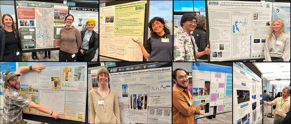
Poster Presenters at 2025 IEP Workshop
CAWSC poster presenters at 2025 IEP Workshop. Clockwise from upper left: Anna Conlen, Elise Shea, Lex Thomas, Zoё Siman-Tov, Bryan Gopez, Emma Walker, David Hart, Maura Uebner, Lawrence Fujiwara, Trevor Violette.
CAWSC poster presenters at 2025 IEP Workshop. Clockwise from upper left: Anna Conlen, Elise Shea, Lex Thomas, Zoё Siman-Tov, Bryan Gopez, Emma Walker, David Hart, Maura Uebner, Lawrence Fujiwara, Trevor Violette.

CAWSC Biogeochemistry group at 2025 IEP Workshop
CAWSC Biogeochemistry group at 2025 IEP Workshop. Left to Right: Back Row - Maura Uebner, Keith Bouma-Gregson, Kyle Leathers; Middle Row - Crystal Sturgeon, Zoё Siman-Tov, Lane Bratz, Emily Richardson, Tamara Kraus, Alex Ryan; Front Row - Nick Framsted
CAWSC Biogeochemistry group at 2025 IEP Workshop. Left to Right: Back Row - Maura Uebner, Keith Bouma-Gregson, Kyle Leathers; Middle Row - Crystal Sturgeon, Zoё Siman-Tov, Lane Bratz, Emily Richardson, Tamara Kraus, Alex Ryan; Front Row - Nick Framsted

Active (or moving) camera footage of Santa Ana Sucker
Active (or moving) camera footage of Santa Ana SuckerActive (or moving) camera footage of Santa Ana Sucker (Pantosteus santaanae). Cameras were attached to “selfie sticks” and walked up and down the raceways (or fabricated streams).
Active (or moving) camera footage of Santa Ana Sucker
Active (or moving) camera footage of Santa Ana SuckerActive (or moving) camera footage of Santa Ana Sucker (Pantosteus santaanae). Cameras were attached to “selfie sticks” and walked up and down the raceways (or fabricated streams).

Open-source image recognition footage of Santa Ana Sucker lure
Open-source image recognition footage of Santa Ana Sucker lureAn open-source image recognition program was used to detect the fish and lures in the videos. The program was “trained” to recognize the fish and lures by exposing it to approximately 800 images of fish and non-fish.

Historical photo is of the Malakoff Diggins hydraulic gold mine
Historical photo is of the Malakoff Diggins hydraulic gold mineHistorical photo of the Malakoff Diggins hydraulic gold mine in the Sierra Nevada in California.
Historical photo is of the Malakoff Diggins hydraulic gold mine
Historical photo is of the Malakoff Diggins hydraulic gold mineHistorical photo of the Malakoff Diggins hydraulic gold mine in the Sierra Nevada in California.

Sample map - Legacy Mercury Contamination in California’s Sierra Nevada
Sample map - Legacy Mercury Contamination in California’s Sierra NevadaSample map - Legacy Mercury Contamination in California’s Sierra Nevada. This map show locations of remediation efforts.
Sample map - Legacy Mercury Contamination in California’s Sierra Nevada
Sample map - Legacy Mercury Contamination in California’s Sierra NevadaSample map - Legacy Mercury Contamination in California’s Sierra Nevada. This map show locations of remediation efforts.

Legacy Mercury Contamination from Historical Gold Mining
Legacy Mercury Contamination from Historical Gold MiningMercury contamination from historic gold mining represents a potential risk to human health and the environment. There is a lack of public awareness of the history mercury use in gold mining and how it contributed to this situation, and also what the present concerns are. Specifically, the public is not aware of locations and levels of contamination.

Photo of members of the team associated with USGS research done in collaboration with UC Davis.
Photo of members of the team associated with USGS research done in collaboration with UC Davis.The above photo includes members of the team associated with research done in collaboration with UC Davis. From left to right, Angela DePalma-Dow (Lake County, conference co-organizer), Sergio Valbuena (UC Davis), Charles Alpers (USGS), Alicia Cortes (UC Davis), and Samantha Sharp (UC Davis).

Attaching solar panel and antennae
USGS scientists attaching solar panel and antennae to soil moisture response unit.
USGS scientists attaching solar panel and antennae to soil moisture response unit.

Squirrel Creek Panorama
Panorama of area near Squirrel Creek soil moisture response unit installation in California's Feather River watershed.
Panorama of area near Squirrel Creek soil moisture response unit installation in California's Feather River watershed.

Digging pit for the soil moisture sensors
A team member helps dig the pit for the soil moisture sensors in the Plumas National Forest in California. Inset: close-up of soil removed from Squirrel Creek pit.
A team member helps dig the pit for the soil moisture sensors in the Plumas National Forest in California. Inset: close-up of soil removed from Squirrel Creek pit.

Soil moisture sensors positioned in pit.
Soil moisture sensors positioned in pit at different depths. Inset: close-up of sensor showing the two probes that gather the data.
Soil moisture sensors positioned in pit at different depths. Inset: close-up of sensor showing the two probes that gather the data.

Soil moisture monitoring station mast assembly
Shown clockwise from top left are: 1] setting up mast to support the station components, 2] installing data logging and transmitting equipment, 3] attaching solar panel and antennae, 4] finished assembly.
Shown clockwise from top left are: 1] setting up mast to support the station components, 2] installing data logging and transmitting equipment, 3] attaching solar panel and antennae, 4] finished assembly.
Science and Products
Filter Total Items: 18
Monitoring and modeling soil moisture to improve runoff forecasting and drought characterization in the Feather River Basin
Drought, along with recent wildfires, have had enormous impacts downstream on water quantity and quality. These conditions have greatly impacted the agriculture and the residents of the nearby Central Valley.
USGS Participates in 2021 Orange County Youth Environmental Summit USGS Participates in 2021 Orange County Youth Environmental Summit
From April 19th through the 23rd, 2021, the USGS California Water Science Center (CAWSC) participated in the first virtual Orange County Youth Environmental Summit (YES). The award-winning program, formerly known as the Children's Water Education Festival, offers 3rd, 4th, and 5th graders opportunities for learning and engagement. Through interactive sessions, YES teaches youth that
Groundwater Ambient Monitoring & Assessment (GAMA)
The Groundwater Ambient Monitoring and Assessment Program’s Priority Basin Project (GAMA-PBP) was established by the California State Water Resources Control Board (SWRCB) in response to the Ground-Water Quality Monitoring Act of 2001 (Sections 10780-10782.3 of the California Water Code). The USGS is the technical lead for the GAMA-PBP and between 2004-2012 focused on characterizing the quality of...
USGS Participates in Earth Day Festivities on Alcatraz Island USGS Participates in Earth Day Festivities on Alcatraz Island
On April 20th, the USGS California Water Science Center (CAWSC) participated in annual Earth Day festivities on Alcatraz Island in San Francisco Bay. Involvement in the event included science presentations on the island, demonstrating the ongoing research of the USGS Estuarine Hydrodynamics and Sediment Transport team based in Sacramento.
Yucaipa Subbasin Integrated Hydrologic Model
The USGS is developing a hydrologic model of the Yucaipa Subbasin to aid in evaluating and managing the groundwater resources in the area. The study results will provide a greater understanding of the geohydrology of the subbasin, and aid in the development of a groundwater-monitoring plan, as well as in the evaluation of potential hydrologic effects of future groundwater development and...
Yucaipa Valley Hydrogeology
This study assesses the quality of water in the Yucaipa area, primarily in the Yucaipa plain. This hydrogeology study will aid local water purveyors in understanding and evaluating local resources and using those resources effectively in combination with water imported from northern California and from the adjacent San Bernardino area.
Low Intensity Chemical Dosing (LICD)
Rivers, wetlands, and agricultural operations supply natural organic material to the Sacramento-San Joaquin Delta (Delta) and the San Francisco Estuary. This natural organic matter provides many ecosystem benefits, but it also adversely affects drinking water. During drinking water treatment, chlorine added for purposes of pathogen control reacts with dissolved organic carbon (DOC) in the water to...
California Water Use
The U.S. Geological Survey's National Water-Use Information Program compiles the nation's water-use data at the county, state, and national levels. USGS five-year reports on national and state water-use estimates between 1950-2015 are posted on the web at: https://water.usgs.gov/watuse/. USGS water-use data for states and counties for 1985-2015 are available at: https://waterdata.usgs.gov/nwis/wu.
Wildfire Effect on Mercury Levels in Putah and Cache Creek Watersheds
A serious consequence of wildfires is the erosion which occurs during storm events in areas where vegetation has been burned away. In cases where such land is near a creek or stream, mercury (Hg) and other contaminants from the eroding soil can make their way into the waterways, impacting the health of fish and wildlife, and the quality of the water supply for local communities (see: USGS Fact...
Effects of Aquatic Vegetation on Water Quality and Residence Time in the Bay-Delta
The spread of invasive aquatic vegetation in the Sacramento-San Joaquin Delta is having a profound impact on the Delta’s natural habitat. The presence of these “aquatic weeds” has been shown to alter water velocity and increase water clarity, posing threats to native fish species, specifically the threatened Delta Smelt. These aquatic plants can also affect the foodweb by altering nutrient...
Temecula Hydrogeology
This site provides hydrologic data collected or compiled by the USGS for the Temecula area; some additional data may be available from the USGS database National Water Information System (NWIS).
San Bernardino Optimal Basin Management
The San Bernardino area of southern California has complex water-management issues. As an aid to local water managers, this report provides an integrated analysis of the surface-water and ground-water systems, documents ground-water flow and constrained optimization models, and provides seven examples using the models to better understand and manage water resources of the area. As an aid to...
Filter Total Items: 27
West Sacramento Projects Office
The West Sacramento Projects Office is the primary home the CAWSC Hydrodynamics and Ecology Program and also houses members of the Biogeochemistry group. These are pictures of the facility.
The West Sacramento Projects Office is the primary home the CAWSC Hydrodynamics and Ecology Program and also houses members of the Biogeochemistry group. These are pictures of the facility.
Understanding Harmful Algal Bloom (HAB) Transport Dynamics by Sampling Toxins in Shellfish
Understanding Harmful Algal Bloom (HAB) Transport Dynamics by Sampling Toxins in ShellfishThese photos are of shellfish sampling which took place at Martinez Harbor in Contra Costa County, California on December 18, 2025. For this study, shellfish traps were baited and deployed for two days in the water before being retrieved. All shellfish were collected, species identified, and individuals measured with calipers. These photos show P.
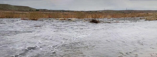
Mojave River during high flow
This picture shows the Mojave River in southern California during a high flow stage.
This picture shows the Mojave River in southern California during a high flow stage.
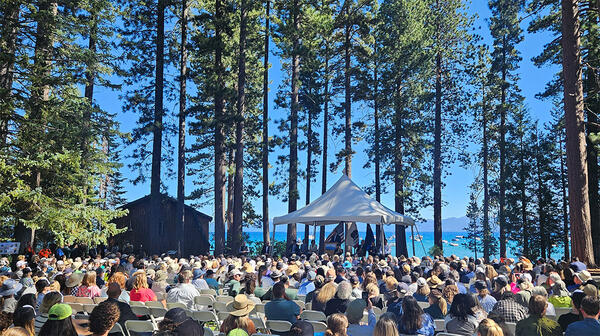
Crowd gathered at 2025 Tahoe Summit
Crown gathered at 2025 Tahoe Summit. The Lake Tahoe Summit is an annual event that brings local, federal, and state leaders together to discuss ways to protect Lake Tahoe and strengthen the partnership underlying the Lake Tahoe Environmental Improvement Program.
Crown gathered at 2025 Tahoe Summit. The Lake Tahoe Summit is an annual event that brings local, federal, and state leaders together to discuss ways to protect Lake Tahoe and strengthen the partnership underlying the Lake Tahoe Environmental Improvement Program.
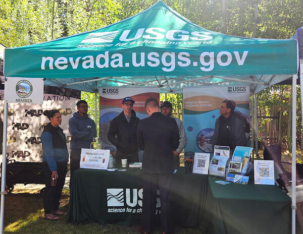
USGS booth at 2025 Tahoe Summit.
USGS booth at 2025 Tahoe Summit. Pictured from left, Sara Doyle (NV WSC), Zach Hood (NV WSC), David Smith (NV WSC), Ed Parvin (CAWSC) and Mark Dickman (CAWSC). Photograph by Ramon Naranjo (NV WSC) on 8/6/25.
USGS booth at 2025 Tahoe Summit. Pictured from left, Sara Doyle (NV WSC), Zach Hood (NV WSC), David Smith (NV WSC), Ed Parvin (CAWSC) and Mark Dickman (CAWSC). Photograph by Ramon Naranjo (NV WSC) on 8/6/25.
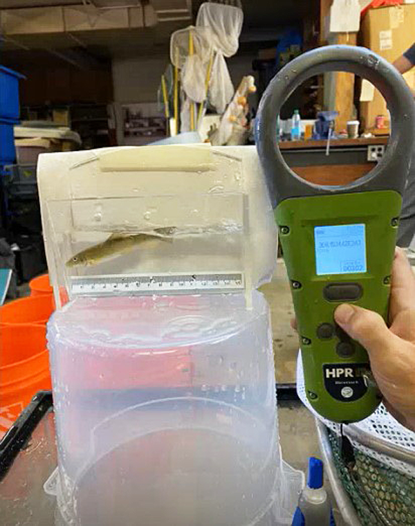
PIT tag reader being tested
This photo shows a passive integrated transponder (PIT) tag reader being used to test a tagged Santa Ana Sucker.
This photo shows a passive integrated transponder (PIT) tag reader being used to test a tagged Santa Ana Sucker.
Raceways at the RCD facility
The above photos show raceways at the Riverside Corona Resource Conservation District (RCD) facility.
The above photos show raceways at the Riverside Corona Resource Conservation District (RCD) facility.
Santa Ana Sucker research team
The photo shows members of the research team. From left to right: Tevin Bui (RCD), Jordan Buxton (USGS), Brett Mills (RCD), Alicia Ruan (RCD), and Brock Huntsman (USGS). Inset at right are Marissa Wulff (top) and Jeff Gronemyer (bottom), both of the USGS.
The photo shows members of the research team. From left to right: Tevin Bui (RCD), Jordan Buxton (USGS), Brett Mills (RCD), Alicia Ruan (RCD), and Brock Huntsman (USGS). Inset at right are Marissa Wulff (top) and Jeff Gronemyer (bottom), both of the USGS.
Poster Presenters at 2025 IEP Workshop
CAWSC poster presenters at 2025 IEP Workshop. Clockwise from upper left: Anna Conlen, Elise Shea, Lex Thomas, Zoё Siman-Tov, Bryan Gopez, Emma Walker, David Hart, Maura Uebner, Lawrence Fujiwara, Trevor Violette.
CAWSC poster presenters at 2025 IEP Workshop. Clockwise from upper left: Anna Conlen, Elise Shea, Lex Thomas, Zoё Siman-Tov, Bryan Gopez, Emma Walker, David Hart, Maura Uebner, Lawrence Fujiwara, Trevor Violette.
CAWSC Biogeochemistry group at 2025 IEP Workshop
CAWSC Biogeochemistry group at 2025 IEP Workshop. Left to Right: Back Row - Maura Uebner, Keith Bouma-Gregson, Kyle Leathers; Middle Row - Crystal Sturgeon, Zoё Siman-Tov, Lane Bratz, Emily Richardson, Tamara Kraus, Alex Ryan; Front Row - Nick Framsted
CAWSC Biogeochemistry group at 2025 IEP Workshop. Left to Right: Back Row - Maura Uebner, Keith Bouma-Gregson, Kyle Leathers; Middle Row - Crystal Sturgeon, Zoё Siman-Tov, Lane Bratz, Emily Richardson, Tamara Kraus, Alex Ryan; Front Row - Nick Framsted
Active (or moving) camera footage of Santa Ana Sucker
Active (or moving) camera footage of Santa Ana SuckerActive (or moving) camera footage of Santa Ana Sucker (Pantosteus santaanae). Cameras were attached to “selfie sticks” and walked up and down the raceways (or fabricated streams).
Active (or moving) camera footage of Santa Ana Sucker
Active (or moving) camera footage of Santa Ana SuckerActive (or moving) camera footage of Santa Ana Sucker (Pantosteus santaanae). Cameras were attached to “selfie sticks” and walked up and down the raceways (or fabricated streams).
Open-source image recognition footage of Santa Ana Sucker lure
Open-source image recognition footage of Santa Ana Sucker lureAn open-source image recognition program was used to detect the fish and lures in the videos. The program was “trained” to recognize the fish and lures by exposing it to approximately 800 images of fish and non-fish.
Historical photo is of the Malakoff Diggins hydraulic gold mine
Historical photo is of the Malakoff Diggins hydraulic gold mineHistorical photo of the Malakoff Diggins hydraulic gold mine in the Sierra Nevada in California.
Historical photo is of the Malakoff Diggins hydraulic gold mine
Historical photo is of the Malakoff Diggins hydraulic gold mineHistorical photo of the Malakoff Diggins hydraulic gold mine in the Sierra Nevada in California.
Sample map - Legacy Mercury Contamination in California’s Sierra Nevada
Sample map - Legacy Mercury Contamination in California’s Sierra NevadaSample map - Legacy Mercury Contamination in California’s Sierra Nevada. This map show locations of remediation efforts.
Sample map - Legacy Mercury Contamination in California’s Sierra Nevada
Sample map - Legacy Mercury Contamination in California’s Sierra NevadaSample map - Legacy Mercury Contamination in California’s Sierra Nevada. This map show locations of remediation efforts.
Legacy Mercury Contamination from Historical Gold Mining
Legacy Mercury Contamination from Historical Gold MiningMercury contamination from historic gold mining represents a potential risk to human health and the environment. There is a lack of public awareness of the history mercury use in gold mining and how it contributed to this situation, and also what the present concerns are. Specifically, the public is not aware of locations and levels of contamination.
Photo of members of the team associated with USGS research done in collaboration with UC Davis.
Photo of members of the team associated with USGS research done in collaboration with UC Davis.The above photo includes members of the team associated with research done in collaboration with UC Davis. From left to right, Angela DePalma-Dow (Lake County, conference co-organizer), Sergio Valbuena (UC Davis), Charles Alpers (USGS), Alicia Cortes (UC Davis), and Samantha Sharp (UC Davis).
Attaching solar panel and antennae
USGS scientists attaching solar panel and antennae to soil moisture response unit.
USGS scientists attaching solar panel and antennae to soil moisture response unit.
Squirrel Creek Panorama
Panorama of area near Squirrel Creek soil moisture response unit installation in California's Feather River watershed.
Panorama of area near Squirrel Creek soil moisture response unit installation in California's Feather River watershed.
Digging pit for the soil moisture sensors
A team member helps dig the pit for the soil moisture sensors in the Plumas National Forest in California. Inset: close-up of soil removed from Squirrel Creek pit.
A team member helps dig the pit for the soil moisture sensors in the Plumas National Forest in California. Inset: close-up of soil removed from Squirrel Creek pit.
Soil moisture sensors positioned in pit.
Soil moisture sensors positioned in pit at different depths. Inset: close-up of sensor showing the two probes that gather the data.
Soil moisture sensors positioned in pit at different depths. Inset: close-up of sensor showing the two probes that gather the data.
Soil moisture monitoring station mast assembly
Shown clockwise from top left are: 1] setting up mast to support the station components, 2] installing data logging and transmitting equipment, 3] attaching solar panel and antennae, 4] finished assembly.
Shown clockwise from top left are: 1] setting up mast to support the station components, 2] installing data logging and transmitting equipment, 3] attaching solar panel and antennae, 4] finished assembly.