
Whitney Creek on the slopes of Mount Shasta in northern California is regularly reshaped by debris flows, created by melting snow and ice or precipitation. Although the stream channel itself is relatively small, these flows are capable of carrying large volumes of volcanic debris, including boulders in excess of several meters. USGS photo by J. Ball.
Images
Images related to Mount Shasta.
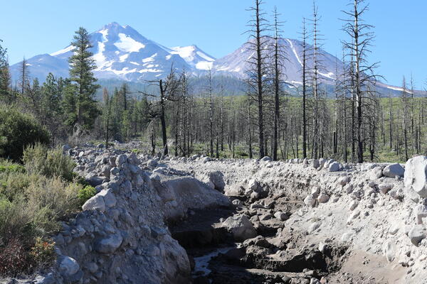
Whitney Creek, Mount Shasta, California
Whitney Creek on the slopes of Mount Shasta in northern California is regularly reshaped by debris flows, created by melting snow and ice or precipitation. Although the stream channel itself is relatively small, these flows are capable of carrying large volumes of volcanic debris, including boulders in excess of several meters. USGS photo by J. Ball.
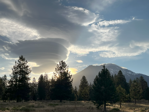
Lenticular clouds over Mount Shasta
Lenticular clouds form when moist air flows up the slopes of a volcano (or other peak), cools, and condenses. The resulting clouds often drop a bit after pushing over the summit, like an eddy over a rock in a stream, and create seemingly stationary shapes that hover over the landscape. USGS photo by Andrew Calvert.
Lenticular clouds form when moist air flows up the slopes of a volcano (or other peak), cools, and condenses. The resulting clouds often drop a bit after pushing over the summit, like an eddy over a rock in a stream, and create seemingly stationary shapes that hover over the landscape. USGS photo by Andrew Calvert.

Phil Dawson at Mount Shasta
Phil Dawson, a Volcano Seismologist with the California Volcano Observatory, stands next to a volcanic rock on the flank of Mount Shasta, California.
Phil Dawson, a Volcano Seismologist with the California Volcano Observatory, stands next to a volcanic rock on the flank of Mount Shasta, California.

Mount Shasta, a steep-sided Cascade Range stratovolcano in Northern Ca
Mount Shasta, a steep-sided Cascade Range stratovolcano in Northern CaMount Shasta, a steep-sided Cascade Range stratovolcano in Northern California, looms above Little Glass Mountain, a thick obsidian flow erupted from the Medicine Lake shield volcano about 1,000 years ago. These are just two of the young volcanic areas monitored by the USGS California Volcano Observatory. USGS photo.

View of a snow-covered Mount Shasta, CA, photo taken in June 2017
View of a snow-covered Mount Shasta, CA, photo taken in June 2017The photo was taken from a vantage looking up Avalanche Gulch at Red Banks (a line of cliffs along the ridge central to the photograph).
View of a snow-covered Mount Shasta, CA, photo taken in June 2017
View of a snow-covered Mount Shasta, CA, photo taken in June 2017The photo was taken from a vantage looking up Avalanche Gulch at Red Banks (a line of cliffs along the ridge central to the photograph).

Plot of quakes in Mount Shasta region greater M1.0 from 2010 to 2016
Plot of quakes in Mount Shasta region greater M1.0 from 2010 to 2016Plot of earthquakes in Mount Shasta region greater than M1.0 from April 3, 2010 to April 3, 2015.
Plot of quakes in Mount Shasta region greater M1.0 from 2010 to 2016
Plot of quakes in Mount Shasta region greater M1.0 from 2010 to 2016Plot of earthquakes in Mount Shasta region greater than M1.0 from April 3, 2010 to April 3, 2015.

Mount Shasta, CA simplified hazards map
Mount Shasta, California simplified hazards map showing potential impact area for ground-based hazards during a volcanic event.
Mount Shasta, California simplified hazards map showing potential impact area for ground-based hazards during a volcanic event.

Lidar images of Shastina cone, west flank of Mount Shasta, CA. Deta...
Lidar images of Shastina cone, west flank of Mount Shasta, CA. Deta...Lidar images of Shastina cone, west flank of Mount Shasta, California. Details of lava flows and other surficial features are best seen in the image to the right with vegetation removed.

Map showing one-year probability of accumulation of 1 centimeter
Map showing one-year probability of accumulation of 1 centimeterMap showing one-year probability of accumulation of 1 centimeter (0.4 inch) or more of tephra from eruptions of volcanoes in the Cascade Range.
By
Natural Hazards Mission Area, Volcano Hazards Program, California Volcano Observatory, Cascades Volcano Observatory, Crater Lake, Glacier Peak, Lassen Volcanic Center, Medicine Lake, Mount Adams, Mount Baker, Mount Hood, Mount Jefferson, Mount Rainier, Mount Shasta, Mount St. Helens, Newberry, Three Sisters

Eruptions in the Cascade Range during the past 4000 years. USGS GIP 64
Eruptions in the Cascade Range during the past 4000 years. USGS GIP 64Eruptions in the Cascade Range during the past 4000 years. USGS GIP 64
Eruptions in the Cascade Range during the past 4000 years. USGS GIP 64
Eruptions in the Cascade Range during the past 4000 years. USGS GIP 64Eruptions in the Cascade Range during the past 4000 years. USGS GIP 64

Mount Shasta, CA
Aerial photo of Mount Shasta's southwestern flank in a low-snow period. The Hotlum cone is on the right, while the Shastina dome is to the left.
Aerial photo of Mount Shasta's southwestern flank in a low-snow period. The Hotlum cone is on the right, while the Shastina dome is to the left.

Stereograph photo of Mount Shasta and the town of Sisson in 1906
Stereograph photo of Mount Shasta and the town of Sisson in 1906Horse-drawn carriage on road in Sisson, California, El Monte Hotel in foreground, Mount Shasta in the background. Image courtesy of the Library of Congress.
Stereograph photo of Mount Shasta and the town of Sisson in 1906
Stereograph photo of Mount Shasta and the town of Sisson in 1906Horse-drawn carriage on road in Sisson, California, El Monte Hotel in foreground, Mount Shasta in the background. Image courtesy of the Library of Congress.

Town of Sisson at the foot of Mount Shasta in winter, ca.1900
Town of Sisson at the foot of Mount Shasta in winter, ca.1900Photograph of the town of Sisson (later (1922) the town of Mt. Shasta) in the distance at the foot of Mount Shasta in winter. Snow covered fir trees in the foreground. Photo courtesy of University of Southern California Libraries and California Historical Society. Digitally reproduced by the USC Digital Library.