
Landsat 9 Products Impacted by 2025 Safehold Now Available
Landsat 9 data acquired following an October 2025 safehold event were recently processed into Landsat Level-1 and Level-2 products for the first time and are now available for download.
Additionally, a small number of Landsat products processed just prior and just after the safehold were also reprocessed.
In October 2025, Landsat 9’s sensors—the Operational Land Imager and Thermal Infrared Sensor—did not acquire data from midday October 17 (DOY 290) to midday October 22 (DOY 295) due to the spacecraft entering a safehold.
After the safehold ended, imaging resumed. The data acquired between 11:47 a.m. CDT on October 22 to 2:43 p.m. CDT on October 24 were held and not processed into products so the USGS-NASA Calibration/Validation Team could verify the data’s integrity.
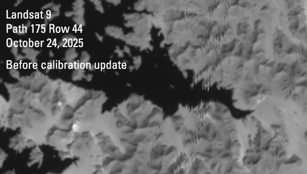
Following their analysis, the team applied updated radiometric and geometric calibration coefficients to the data and generated 1,585 new Level-1 products, which are now available for download. The follow-on generation of Landsat Level-2, Landsat U.S. Analysis Ready Data (ARD), and Level-3 science products are in process.
In addition to the newly processed products, 42 Level-1 products from October 17, and 13 products from October 24, were reprocessed with updated radiometric correction parameters. Newly generated Level-1 and Level-2 products have replaced those already visible on EarthExplorer (EE) and other USGS data access sources. Landsat U.S. Analysis Ready Data (ARD) and Level-3 products will also be regenerated in the near future.
The EE Product Identifiers contain the updated processing dates for the affected products; users are encouraged to double check the processing date of Landsat 9 scenes acquired on October 17 and October 24 to ensure the most recent data are being used. The Landsat Reprocessing Events application has been updated to include details about these products.
Please contact EROS User Services with any questions.
Return to all Landsat Headlines
Related
Landsat 9 Returns to Normal Operations Following Brief Safehold Landsat 9 Returns to Normal Operations Following Brief Safehold
Related