
Latest in Landsat March 2026 - Vol. 5 | Issue 3
Latest News
-

2026 William T. Pecora Award Nominations Being Accepted 2026 William T. Pecora Award Nominations Being Accepted
The William T. Pecora Award is presented annually to individuals or teams using satellite or aerial remote sensing that make outstanding contributions toward understanding the Earth (land, oceans, and air), educating the next generation of scientists, informing decision-makers, or supporting natural or human-induced disaster response. Both national and international nominations are welcome.
ICYMI: Cloud-access Tutorials are Available to You
Last month, we highlighted new tutorials that help users access and work with Landsat data stored in a commercial cloud environment more effectively. Whether you are just getting started, or you have experience in using SpatioTemporal Asset Catalog (STAC) in a commercial cloud environment to access Landsat data, these tutorials can help you refine your processes to compile the Landsat data you need as quickly as possible.
Visit the EROS User Services code repository to browse through the topics describing how to access and process data in the cloud.
Check out These Helpful Applications

Spectral Characteristics Viewer
The Spectral Characteristics Viewer allows users to determine which satellite bands are best suited for research applications.

Landsat Interactives
These webpages use maps, images, and stories to show how Landsat satellites help people around the world. They highlight real examples—like tracking city growth, supporting farmers, managing water, and responding to natural disasters—making it easy to see how Landsat data benefits everyday life.
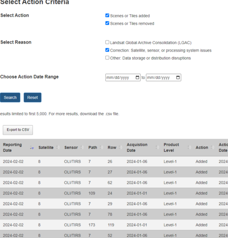
Landsat Reprocessing Events Search Application
The Landsat Reprocessing Application allows you to discover scene and tile products that have been changed by reprocessing.
Got Questions? We’ve Got Answers!
-

Landsat Frequently Asked Questions Landsat Frequently Asked Questions
This page lists commonly asked questions pertaining to the Landsat satellite missions, the science behind maintaining high quality Landsat data, and what products are available - and how to download them.
-
Landsat Glossary and Acronyms Landsat Glossary and Acronyms
The Landsat project uses many technical terms and acronyms to describe the satellite systems, sensors, and data formats. This information is vital for interpreting satellite imagery and using Landsat data in research and environmental monitoring. Access this information to locate the terms to learn more!
-

Connect Connect
Access the information on this page to learn more about Landsat, access our social media platforms, or contact us with questions you have about the Landsat missions, the available science products, and how to access Landsat data!
Stay Informed with the Latest in Landsat Newsletter
Direct to your inbox! Landsat's monthly newsletter features current news, uses, tools, and announcements about America's Earth-observing satellite program.