
Earth Observing Satellites Online Compendium
View information on past, current and future land remote sensing satellites and their sensors
Joint Agency Commercial Imagery Evaluation (JACIE) Workshops
Sponsored by government agencies and allow remote sensing experts to discuss system capabilities, calibration, and the impacts of data quality on various applications
Landsat Satellite Offers $25.6 Billion Annually
Study Estimates Landsat 10 Value Could Bring Over $33 Billion
Requirements Capabilities & Analysis for Earth Observations
The USGS National Land Imaging Program evaluates satellite capabilities to determine effective solutions for addressing civil agency and societal challenges, allowing land managers and policymakers to make informed decisions about natural resources and the environment. A user-centered, solution-driven approach creates a robust suite of innovative earth observation technology, data, and services.
Tell Us About Your Needs

Work with us to document your land imaging needs using our standardized data collection process. Once captured, your needs will be available to us and will be considered in all of our activities.
Search Satellite Capabilities

We compile detailed information about U.S., international, and commercial land imaging satellite systems, and provide access to a variety of land imaging data and data products.
How We Inform Decisions

We provide quantitative and qualitative assessments to support investment decisions that will meet the most needs for the most users. Explore how this information is being used to inform decisions.
The following by the numbers graphic illustrates the scope, reach, and achievements of our Earth observation user needs, capabilities, and analysis efforts.
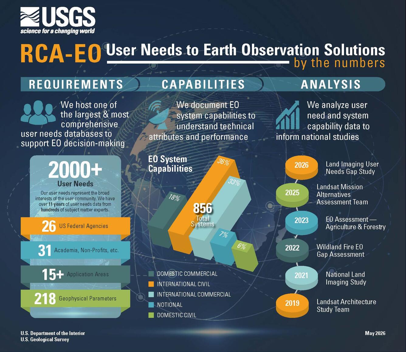
RCA-EO User Needs to Earth Observation Solutions by the numbers graphic
Meetings and Workshops
Joint Agency Commercial Imagery Evaluation (JACIE) Workshops
Annual JACIE Workshops are sponsored by government agencies and allow remote sensing experts to discuss system capabilities, calibration, and the impacts of data quality on various applications. Visit the JACIE Workshops webpage for more information on past and upcoming workshops.

Image Quality Assessment
We evaluate commercial high-resolution satellite imagery to determine how well current and emerging systems meet user needs. We also produce system characterization reports that help government agencies, researchers, and decision-makers understand the strengths and limitations of available Earth observation data by independently assessing image quality, performance, and operational capabilities.
Learn more about data quality assessments.

Landsat Science Products
Landsat science products provide analysis ready data, including surface reflectance, surface temperature, aquatic reflectance, dynamic surface water extent, fractional snow covered area, burned area, and provisional actual evapotranspiration.
Explore Landsat science product here.

Find Land Imaging Data
Landsat and other land imaging products are available from multiple data portals, including EarthExplorer, commercial cloud access, and the EROS Science Processing Architecture On Demand Interface (ESPA), which supports higher-level data processing requests.