
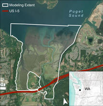
Aerial Map of Modeling Area in the Nisqually River Delta

Detailed Description
Aerial map of modeling area in the Nisqually River Delta. Managed freshwater marsh at the southern end of the refuge is excluded. Inset: Black point on terrain map shows the location of Billy Frank Jr. Nisqually National Wildlife Refuge within Washington State (grey outline).
Sources/Usage
Public Domain.
Related

Marsh Elevation Change and Carbon Sequestration
Tidal marsh vegetation grows in a narrow elevation zone between sea level and the upland behind it. These plant communities have evolved to accumulate sediment over time and maintain their relative elevation with gradual rates of change in sea level. It is uncertain which marsh vegetation communities will be able to accumulate sediment at a rate that keeps pace with accelerated sea level rise.
Related
Marsh Elevation Change and Carbon Sequestration
Tidal marsh vegetation grows in a narrow elevation zone between sea level and the upland behind it. These plant communities have evolved to accumulate sediment over time and maintain their relative elevation with gradual rates of change in sea level. It is uncertain which marsh vegetation communities will be able to accumulate sediment at a rate that keeps pace with accelerated sea level rise.