Area change of USGS Benchmark Glaciers
Detailed Description
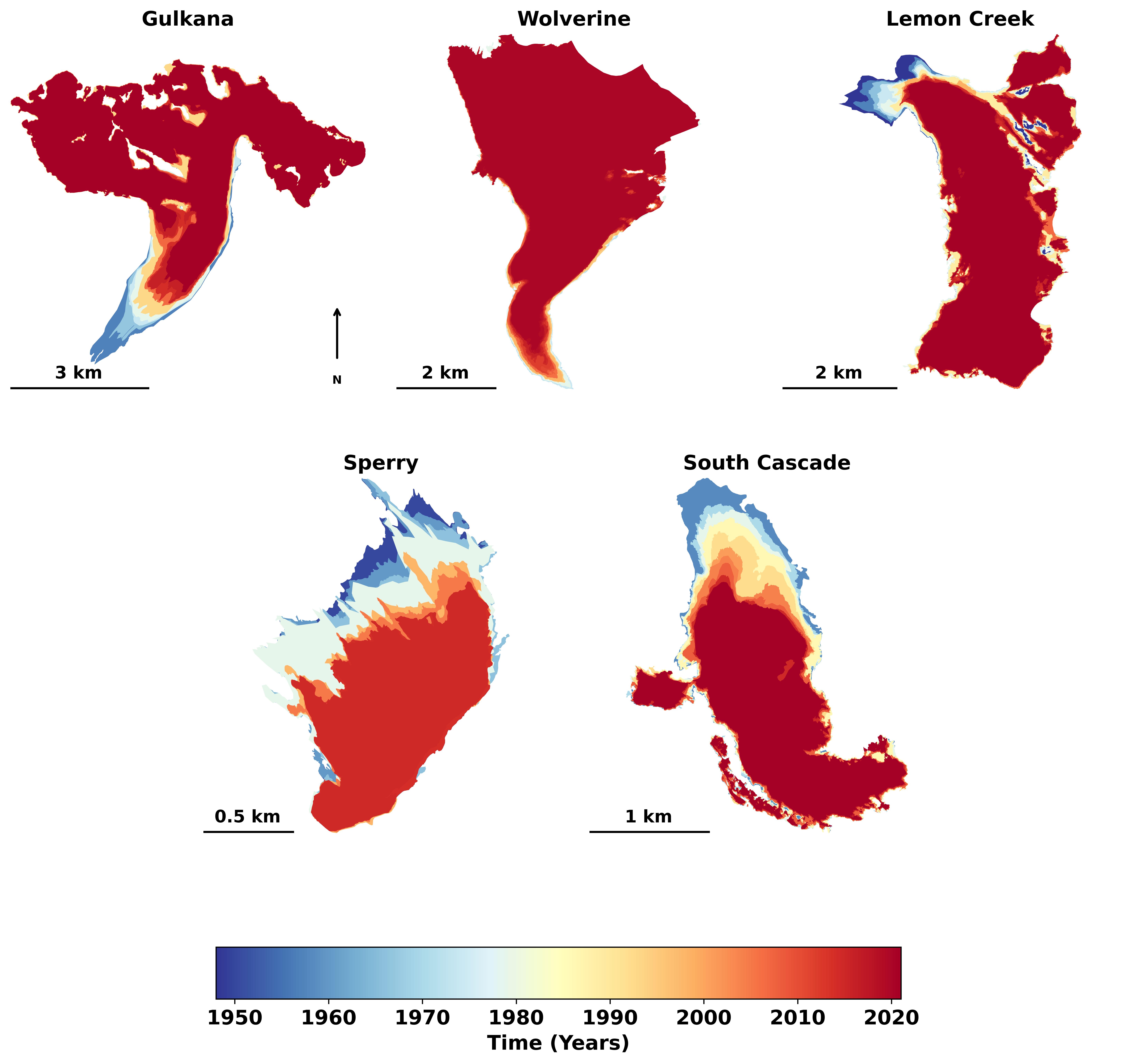
Area change of USGS Benchmark Glaciers. Color represents glacier area at multiple time-steps between 1950s (blue hues) and Present (red hues). Glacier outlines available in a USGS data release (https://doi.org/10.5066/P9R8BP3K).
Sources/Usage
Public Domain.
Related
Glaciers and Landscape Change
Mountain glaciers are dynamic reservoirs of frozen water, deeply interconnected with their surrounding ecosystems. Glacier change in North America has major societal impacts, including to water resources, natural hazard risk, tourism disruption, fisheries, and global sea level change. Understanding and quantifying precise connections between changing glaciers, the surrounding landscape and climate...
Mass Balance Methods: Measuring Glacier Change
Nearly all of Earth's alpine glaciers are losing mass, with consequences for freshwater resources, landscape stability, regional ecosystems, and global sea level. Rates of glacier mass loss in Western North America and Alaska are among the highest on Earth (The GlaMBIE Team, 2025).
Geodetic Data for USGS Glaciers: Orthophotos, Digital Elevation Models, Glacier Boundaries and Surveyed Positions Geodetic Data for USGS Glaciers: Orthophotos, Digital Elevation Models, Glacier Boundaries and Surveyed Positions
This data release provides geodetic measurements collected since the mid-1940s to characterize the surface elevation, area, and motion of glaciers studied by the U.S, Geological Survey. The primary glaciers of focus are the Benchmark Glaciers of North America which include Gulkana, Wolverine, and Lemon Creek Glaciers in Alaska, Sperry Glacier in Montana, and South Cascade Glacier in...
Compiled Input Data and Glacier-Wide Mass Balances Compiled Input Data and Glacier-Wide Mass Balances
This data release includes compiled input data and glacier-wide mass balance data collected on various North American glaciers under various projects and funding sources. Vocabulary used is defined herein and follows Cogley and others (2011) Glossary of Glacier Mass Balance. Input data are of three types: 1) time-variable area altitude distribution (AAD); 2) time series of point mass...