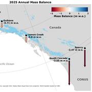
Glaciology, mass balance, mountain glacier dynamics, glacier response to climate forcing
Professional Experience
2012 - Present Physical Scientist, USGS Alaska Science Center
2009 - 2011 Instructor, Alaska Pacific University, Glaciology and Glacier Travel field course
2009 - 2012 Student Trainee, USGS Alaska Science Center
Education and Certifications
M.S. 2011 Alaska Pacific University, Anchorage, AK Environmental Science
B.A. 2000 The Colorado College, Colorado Springs, CO Geology
Affiliations and Memberships*
International Glaciological Society
American Geophysical Union
Honors and Awards
NASA Earth and space science fellowship, 2009-2011
Science and Products
Glaciers and Climate Project
Gulkana Glacier
Lemon Creek Glacier
Wolverine Glacier
Assessing the Vulnerability of Alaska’s Glaciers in a Changing Climate
USGS Benchmark Glacier Project
Wolverine Glacier Ecosystem Studies
Firn Density and Stratigraphy Observations from USGS Benchmark Glaciers
USGS Benchmark Glacier Mass Balance and Project Data
Point Raw Glaciological Data: Ablation Stake, Snow Pit, and Probed Snow Depth Data on USGS Benchmark Glaciers
Geodetic Data for USGS Benchmark Glaciers: Orthophotos, Digital Elevation Models, Glacier Boundaries and Surveyed Positions
Glacier-Wide Mass Balance and Compiled Data Inputs: USGS Benchmark Glaciers
Raw Ground Penetrating Radar Data on North American Glaciers
High Altitude Weather Station Data at USGS Benchmark Glaciers
Uncertainty of ICESat-2 ATL06- and ATL08-derived snow depths for glacierized and vegetated mountain regions
Beyond glacier-wide mass balances: Parsing seasonal elevation change into spatially resolved patterns of accumulation and ablation at Wolverine Glacier, Alaska
The imminent calving retreat of Taku Glacier
Explaining mass balance and retreat dichotomies at Taku and Lemon Creek Glaciers, Alaska
Reanalysis of the U.S. Geological Survey Benchmark Glaciers: Long-term insight into climate forcing of glacier mass balance
Snow and ice
Geometry, mass balance and thinning at Eklutna Glacier, Alaska: an altitude-mass-balance feedback with implications for water resources
Hypsometric control on glacier mass balance sensitivity in Alaska and northwest Canada
End-of-winter snow depth variability on glaciers in Alaska
Assessing streamflow sensitivity to variations in glacier mass balance
Re-analysis of Alaskan benchmark glacier mass-balance data using the index method
Non-USGS Publications**
**Disclaimer: The views expressed in Non-USGS publications are those of the author and do not represent the views of the USGS, Department of the Interior, or the U.S. Government.
Science and Products
- Science
Glaciers and Climate Project
Mountain glaciers are dynamic reservoirs of frozen water closely coupled to ecosystems and climate. Glacier change in North America has major socioeconomic impacts, including global sea level change, tourism disruption, natural hazard risk, fishery effects, and water resource alteration. Understanding and quantifying precise connections between glaciers and climate is critical to decision makers...Gulkana Glacier
Gulkana Glacier is located in the high-latitude continental climate regime of Alaska’s Delta Mountains. Glacier observations began at this site in 1966.Lemon Creek Glacier
Lemon Creek Glacier is located in the high-latitude maritime region of Alaska, at the southernmost tip of the Juneau Icefield. Glacier observations began at this site in 1953.Wolverine Glacier
Wolverine Glacier is located in the high-latitude maritime climate regime of Alaska’s Kenai Mountains. Glacier observations began at this site in 1966.Assessing the Vulnerability of Alaska’s Glaciers in a Changing Climate
Retreating glaciers are an iconic image of climate change;yet not all glaciers in Alaska are actively retreating, and a few glaciers are even advancing. While this contrasting behavior can be misleading for the casual observer, variable responses between glaciers in a changing climate are expected. Glaciers act as conveyor belts that transport snow and ice from high elevations, where it does not mUSGS Benchmark Glacier Project
Scientists with the USGS Benchmark Glacier Project study the process and impacts of glacier change, including sea-level rise, water resources, environmental hazards and ecosystem links. At the core of this research are mass balance measurements at five glaciers in the United States. Since the 1960s, these glaciers have been studied using direct observations of glaciers and meteorology. The project...Wolverine Glacier Ecosystem Studies
This project is an extension of the long-term Wolverine Glacier Benchmark Glacier project and is improving our understanding of solutes and nutrients in glacier basins, and how they fuel downstream ecosystems. - Data
Firn Density and Stratigraphy Observations from USGS Benchmark Glaciers
This dataset contains observations of snow and firn density and stratigraphy from Site EC on Wolverine Glacier. Site EC is located in the accumulation zone on the northwest flank of the upper glacier at 1350m. Cores were recovered using a FELICS corer to approximately 25m depth at the end of the accumulation season and the end of ablation season starting in 2016. Additional cores were drilled throUSGS Benchmark Glacier Mass Balance and Project Data
Since the late 1950s, the USGS has maintained a long-term glacier mass-balance program at three North American glaciers. Measurements began on South Cascade Glacier, WA in 1958, expanding to Gulkana and Wolverine glaciers, AK in 1966, and later Sperry Glacier, MT in 2005. Additional measurements have been made on Lemon Creek Glacier, AK to compliment data collected by the Juneau Icefield ResearchPoint Raw Glaciological Data: Ablation Stake, Snow Pit, and Probed Snow Depth Data on USGS Benchmark Glaciers
Since the late 1950s, the USGS has maintained a long-term glacier mass-balance program at three North American glaciers. Measurements began on South Cascade Glacier, WA in 1958, expanding to Gulkana and Wolverine glaciers, AK in 1966, and later Sperry Glacier, MT in 2005. Additional measurements have been made on Lemon Creek and Taku glaciers, AK to compliment data collected by the Juneau IcefieldGeodetic Data for USGS Benchmark Glaciers: Orthophotos, Digital Elevation Models, Glacier Boundaries and Surveyed Positions
Since the late 1950s, the USGS has maintained a long-term glacier mass-balance program at three North American glaciers. Measurements began on South Cascade Glacier, WA in 1958, expanding to Gulkana and Wolverine glaciers, AK in 1966, and later Sperry Glacier, MT in 2005. Additional measurements have been made on Lemon Creek Glacier, AK to compliment data collected by the Juneau Icefield ResearchGlacier-Wide Mass Balance and Compiled Data Inputs: USGS Benchmark Glaciers
Since the late 1950s, the USGS has maintained a long-term glacier mass-balance program at three North American glaciers. Measurements began on South Cascade Glacier, WA in 1958, expanding to Gulkana and Wolverine glaciers, AK in 1966, and later Sperry Glacier, MT in 2005. Additional measurements have been made on Lemon Creek Glacier, AK to compliment data collected by the Juneau Icefield ResearchRaw Ground Penetrating Radar Data on North American Glaciers
U.S. Geological Survey researchers conducted time-series ground-penetrating radar (GPR) surveys with a Sensors and Software 500-MHz Pulse Ekko Pro system. This data release contains ground-based (ski and snowmobile) as well as airborne common-offset profiles. All profiles are linked to coincident GPS observations. Additionally, common-midpoint data was collected at specific glacier locations. CoinHigh Altitude Weather Station Data at USGS Benchmark Glaciers
Since the late 1950s, the USGS has maintained a long-term glacier mass-balance program at three North American glaciers. Measurements began on South Cascade Glacier, WA in 1958, expanding to Gulkana and Wolverine glaciers, AK in 1966, and later Sperry Glacier, MT in 2005. Additional measurements have been made on Lemon Creek Glacier, AK to compliment data collected by the Juneau Icefield Research - Multimedia
- Publications
Uncertainty of ICESat-2 ATL06- and ATL08-derived snow depths for glacierized and vegetated mountain regions
Seasonal snow melt dominates the hydrologic budget across a large portion of the globe. Snow accumulation and melt vary over a broad range of spatial scales, preventing accurate extrapolation of sparse in situ observations to watershed scales. The lidar onboard the Ice, Cloud, and land Elevation, Satellite (ICESat-2) was designed for precise mapping of ice sheets and sea ice, and here we assess thAuthorsEllyn Enderlin, Colten Elkin, Madeline Gendreau, H. P. Marshall, Shad O'Neel, Christopher J. McNeil, Caitlyn Florentine, Louis C. SassBeyond glacier-wide mass balances: Parsing seasonal elevation change into spatially resolved patterns of accumulation and ablation at Wolverine Glacier, Alaska
We present spatially distributed seasonal and annual surface mass balances of Wolverine Glacier, Alaska, from 2016 to 2020. Our approach accounts for the effects of ice emergence and firn compaction on surface elevation changes to resolve the spatial patterns in mass balance at 10 m scale. We present and compare three methods for estimating emergence velocities. Firn compaction was constrained byAuthorsLucas Zeller, Daniel J McGrath, Louis C. Sass, Shad O'Neel, Christopher J. McNeil, Emily BakerThe imminent calving retreat of Taku Glacier
Along the rugged Southeast Alaska coast, 30 kilometers northeast of the state capital Juneau, a tidewater glacier has largely defied global trends by steadily advancing for most of the past century while most glaciers on Earth retreated. This 55-kilometer-long and nearly 1,500-meter-thick tidewater glacier, named Taku Glacier, or T'aaḵú Ḵwáan Sít'i in the language of the Indigenous Tlingit people,AuthorsChristopher J. McNeil, Jason Amundson, Shad O'Neel, Roman Motyka, Louis C. Sass, Martin Truffer, Jenna Ziemann, Seth CampbellExplaining mass balance and retreat dichotomies at Taku and Lemon Creek Glaciers, Alaska
We reanalyzed mass balance records at Taku and Lemon Creek Glaciers to better understand the relative roles of hypsometry, local climate and dynamics as mass balance drivers. Over the 1946–2018 period, the cumulative mass balances diverged. Tidewater Taku Glacier advanced and gained mass at an average rate of +0.25±0.28 m w.e. a–1, contrasting with retreat and mass loss of –0.60±0.15 m w.e. a-1 atAuthorsChristopher J. McNeil, Shad O'Neel, Michael Loso, Mauri Pelto, Louis C. Sass, Emily Baker, Seth CampbellReanalysis of the U.S. Geological Survey Benchmark Glaciers: Long-term insight into climate forcing of glacier mass balance
Mountain glaciers integrate climate processes to provide an unmatched signal of regional climate forcing. However, extracting the climate signal via intercomparison of regional glacier mass balance records can be problematic when methods for extrapolating and calibrating direct glaciological measurements are mixed or inconsistent. To address this problem, we reanalyzed and compared long-term massAuthorsShad O'Neel, Christopher J. McNeil, Louis C. Sass, Caitlyn Florentine, Emily Baker, Erich Peitzsch, Daniel J McGrath, Andrew G. Fountain, Daniel B. FagreSnow and ice
Temperature and precipitation are key determinants of snowpack levels. Therefore, climate change is likely to affect the role of snow and ice in the landscapes and hydrology of the Chugach National Forest region.Downscaled climate projections developed by Scenarios Network for Alaska and Arctic Planning (SNAP) are useful for examining projected changes in snow at relatively fine resolution using aAuthorsJeremy S. Littell, Stephanie A. McAfee, Shad O'Neel, Louis C. Sass, Evan Burgess, Steve Colt, Paul ClarkGeometry, mass balance and thinning at Eklutna Glacier, Alaska: an altitude-mass-balance feedback with implications for water resources
We analyzed glacier surface elevations (1957, 2010 and 2015) and surface mass-balance measurements (2008–2015) on the 30 km2 Eklutna Glacier, in the Chugach Mountains of southcentral Alaska. The geodetic mass balances from 1957 to 2010 and 2010 to 2015 are −0.52 ± 0.46 and −0.74 ± 0.10 m w.e. a−1, respectively. The glaciological mass balance of −0.73 m w.e. a−1 from 2010 to 2015 is indistinguishabAuthorsLouis C. Sass, Michael G. Loso, Jason Geck, Evan Thoms, Daniel McgrathHypsometric control on glacier mass balance sensitivity in Alaska and northwest Canada
Glacier hypsometry provides a first‐order approach for assessing a glacier's response to climate forcings. We couple the Randolph Glacier Inventory to a suite of in situ observations and climate model output to examine potential change for the ∼27,000 glaciers in Alaska and northwest Canada through the end of the 21st century. By 2100, based on Representative Concentration Pathways (RCPs) 4.5–8.5AuthorsDaniel Mcgrath, Louis C. Sass, Shad O'Neel, Anthony A. Arendt, C. KienholzEnd-of-winter snow depth variability on glaciers in Alaska
A quantitative understanding of snow thickness and snow water equivalent (SWE) on glaciers is essential to a wide range of scientific and resource management topics. However, robust SWE estimates are observationally challenging, in part because SWE can vary abruptly over short distances in complex terrain due to interactions between topography and meteorological processes. In spring 2013, we measuAuthorsDaniel Mcgrath, Louis C. Sass, Shad O'Neel, Anthony Arendt, Gabriel Wolken, Alessio Gusmeroli, Christian Kienholz, Christopher J. McNeilAssessing streamflow sensitivity to variations in glacier mass balance
The mountains ringing the Gulf of Alaska (GOA) receive upwards of 4–8 m yr−1 of precipitation (Simpson et al.2005; Weingartner et al. 2005; O’Neel 2012), much of which runs off into productive coastal waters. The alpine landscape is heavily glacierized, and storage and turnover of water by glaciers substantially influences the regional surface water balance (Neal et al. 2010). In turn, the land-toAuthorsShad O'Neel, Eran Hood, Anthony Arendt, Louis C. SassRe-analysis of Alaskan benchmark glacier mass-balance data using the index method
At Gulkana and Wolverine Glaciers, designated the Alaskan benchmark glaciers, we re-analyzed and re-computed the mass balance time series from 1966 to 2009 to accomplish our goal of making more robust time series. Each glacier's data record was analyzed with the same methods. For surface processes, we estimated missing information with an improved degree-day model. Degree-day models predict ablatiAuthorsAshely E. Van Beusekom, Shad R. O'Nell, Rod S. March, Louis C. Sass, Leif H. CoxNon-USGS Publications**
Sugden, D. E., G. A. Balco, S. G. Cowdery, J. O. Stone, and L. C. Sass. 2005. Selective glacial erosion and weathering zones in the coastal mountains of Marie Byrd Land, Antarctica. Geomorphology 67:317-334. doi:10.1016/j.geomorph.2004.10.007Siddoway, C. S., L. C. Sass, and R. P. Esser. 2005. Kinematic history of western Marie Byrd Land, West Antarctica: Direct evidence from Cretaceous mafic dykes. Geological Society, London, Special Publications 246:417-438. doi:10.1144/GSL.SP.2005.246.01.17Stone, J. O., G. A. Balco, D. E. Sugden, M. W. Caffee, L. C. Sass, S. G. Cowdery, and C. S. Siddoway. 2003. Holocene deglaciation of Marie Byrd Land, West Antarctica. Science 299(5603):99-102. doi:10.1126/science.1077998McGrath, D. , Sass, L. , O'Neel, S. , Arendt, A. and Kienholz, C. (2017), Hypsometric control on glacier mass balance sensitivity in Alaska and northwest Canada. Earth's Future, 5: 324-336. doi:10.1002/2016EF000479**Disclaimer: The views expressed in Non-USGS publications are those of the author and do not represent the views of the USGS, Department of the Interior, or the U.S. Government.
- News
*Disclaimer: Listing outside positions with professional scientific organizations on this Staff Profile are for informational purposes only and do not constitute an endorsement of those professional scientific organizations or their activities by the USGS, Department of the Interior, or U.S. Government