
Changes to Mud Creek digital surface models

Detailed Description
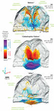
Computer images showing the coastal cliff area of Mud Creek on the Big Sur coastline, central California, where on May 20, 2017 a catastrophic landslide destroyed over 400 meters of scenic California State Highway 1. These illustrations show the changes to the digital surface models of Mud Creek during the three primary phases of the landslide: (a) before, (b) immediately after the catastrophic failure, and (c) during the 9 months after the failure on May 20, 2017. The dates of acquisition for each of these phases are provided along the right-hand side.