
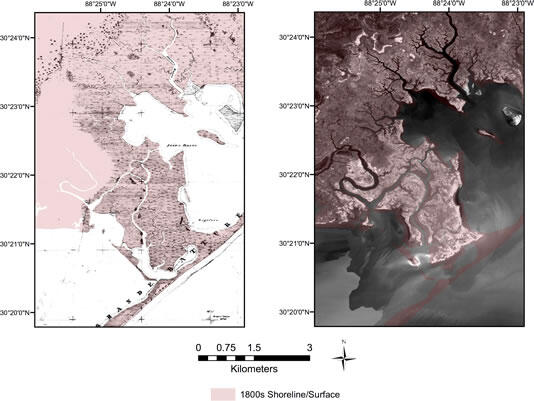
Comparison between 1848 and 2006 map
Detailed Description
A simple comparison between the 1848 U.S. Coastal and Geodetic Survey T-Sheet #243 map (left) and the 2006 U.S. Department of Agriculture (USDA) National Agriculture Imagery Product (right) for the Grand Bay region located at the border of Mississippi and Alabama. A digitized surface/shoreline from the 1848 survey is presented in red and overlain onto the National Agriculture Imagery Program (NAIP) image to highlight the extensive estuarine marsh-wetland area loss.
Sources/Usage
Public Domain.
Related

Sea-level and Storm Impacts on Estuarine Environments and Shorelines (SSIEES)
This project assesses the physical controls of sediment and material exchange between wetlands and estuarine environments along the northern Gulf of America (Grand Bay Alabama/Mississippi and Vermilion Bay, Louisiana) and the Atlantic coast (Chincoteague Bay, Virginia/Maryland).
Related
Sea-level and Storm Impacts on Estuarine Environments and Shorelines (SSIEES)
This project assesses the physical controls of sediment and material exchange between wetlands and estuarine environments along the northern Gulf of America (Grand Bay Alabama/Mississippi and Vermilion Bay, Louisiana) and the Atlantic coast (Chincoteague Bay, Virginia/Maryland).