
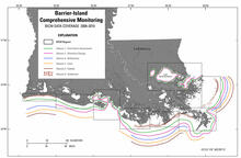
Data-coverage map for each BICM task
By St. Petersburg Coastal and Marine Science Center
2016 (approx.)

Detailed Description
Data-coverage map for each State of Louisiana Barrier Island Comprehensive Monitoring (BICM) task: barrier-shoreline post-storm assessment, historical shoreline changes, bathymetric and historical seafloor change, lidar surveys for the Louisiana coast, habitat mapping and change analysis, and characterization of coastal surface-sediment samples.
Sources/Usage
Public Domain.
Related

Barrier Island Comprehensive Monitoring
Historical and newly acquired data were used to assess and monitor changes in the aerial and subaqueous extent of islands, habitat types, sediment properties, environmental processes, and vegetation composition.
Related
Barrier Island Comprehensive Monitoring
Historical and newly acquired data were used to assess and monitor changes in the aerial and subaqueous extent of islands, habitat types, sediment properties, environmental processes, and vegetation composition.