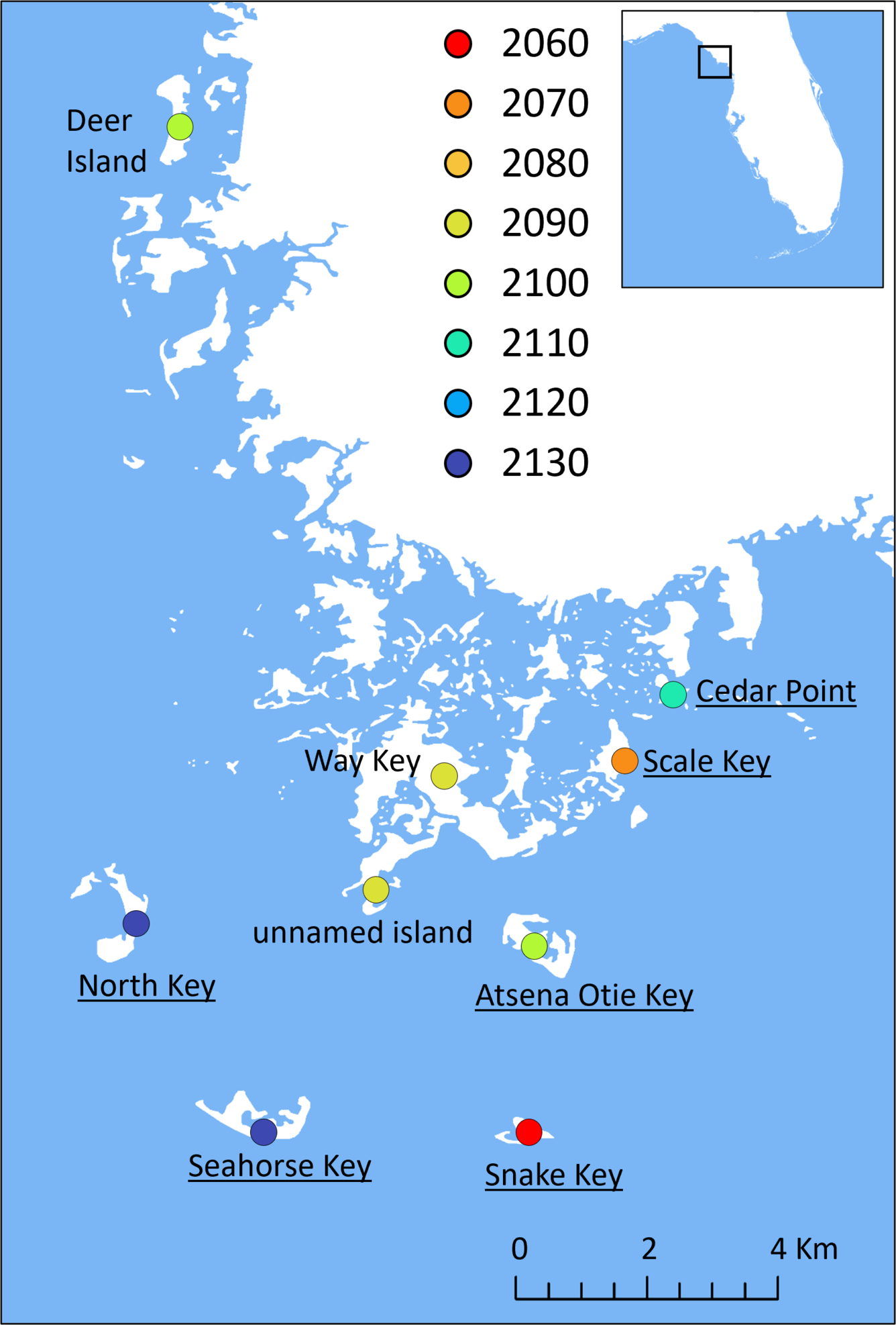
The decade at which >90% of suitable habitat for the Cedar Key mole skink is predicted to be inundated from sea level rise
By Wetland and Aquatic Research Center
January 2024 (approx.)
Detailed Description
The decade at which >90% of suitable habitat for athe Cedar Key mole skink is predicted to be inundated from sea level rise (intermediate sea level rise scenario). In other words, the decade that the models predict populations on each island will be extirpated due to inundation of suitable habitat. Symbol location denotes island polygon centroid and not necessarily the occupied portion of the island. Underlines indicate islands where some maritime hammock habitat is predicted to remain above water as of 2150 (intermediate scenario). The unnamed island (~29.132, -83.053 WGS84) is sometimes also referred to as Airstrip Island, Cedar Key Airstrip, or Cedar Key. Way Key has recent, unvouchered observations.
Sources/Usage
Public Domain.
Related
Insular mole skinks: Area of habitat still above water given projected sea level rise and proportion of habitat at risk of storm surge in the Florida Keys, Cedar Keys, and Egmont Key, Florida
The primary habitats for insular mole skinks in Florida are sand beaches, beach berms, and dunes, making them particularly vulnerable to sea level rise (SLR) and storm surge. We used the most recent SLR projections, high resolution lidar-based digital elevation models, a combination of a comprehensive land cover and hand-digitized aerial imagery, and the latest storm surge simulations to...
Mole Skink (Plestiodon egregius) rMOSKx_CONUS_2001v1 Range Map
This dataset represents a species known range extent for Plestiodon egregius (Mole Skink). These range maps are created by attributing sub-watershed polygons with information of a species presence, origin, seasonal and reproductive use.
Mole Skink (Plestiodon egregius) rMOSKx_CONUS_2001v1 Habitat Map
This dataset represents a species habitat distribution model for Mole Skink. These habitat maps are created by applying a deductive habitat model to remotely-sensed data layers within a species' range.
Vulnerability of endemic insular mole skinks to sea-level rise
Although coastal islands are home to many endemic species, they are also at risk of inundation from storm surge and sea level rise. Three subspecies of mole skink (Plestiodon egregius egregius, P. e. insularis, and the Egmont Key Mole Skink known from a single occurrence) occur on a small number of islands off the Gulf Coast of Florida, USA. We used the most recent sea level rise...
Authors
Erin L. Koen, William Barichivich, Susan Walls
Vulnerability of Mole Skinks to Sea-Level Rise
Mole skinks that occur on Florida’s islands rely on sand beaches, beach berms, and dunes, making them particularly vulnerable to sea level rise and storm surge. USGS researchers predicted the impacts of sea level rise and storm surge on habitat for the Florida Keys mole skink ( Plestiodon egregius egregius), the Cedar Key mole skink ( P. e. insularis), and the Egmont Key mole skink (known from a...