
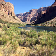
Diagram of vegetation monitoring sites along the Colorado River
By Southwest Biological Science Center
2018 (approx.)

Detailed Description
Image depicting the vegetation program’s field methods and data collection techniques can show patterns, trends, and changes throughout the Colorado River corridor downstream of the Glen Canyon Dam.
Sources/Usage
Public Domain.
Related
Vegetation monitoring: How one square meter can tell the story of 255 river miles along the Colorado River
The goal of SBSC's Grand Canyon Monitoring and Research Center’s (GCMRC) riparian vegetation monitoring program is to assess changes and trends in plant species composition and cover and relate those changes to river hydrology, climate, geomorphology, and the operations of Glen Canyon Dam.