
Enhanced Landsat 8 Image of Western Australia

Detailed Description
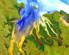
This image is a portion of the first Landsat 8 scene acquired May 12, 2013 (Path 107, Rows 70-71) in Western Australia. Geoscience Australia, a Landsat International Cooperator and a Landsat Science Team member, produced this enhanced image. Water and land were masked, separately enhanced, and then reassembled.
The water patterns are the result of an RGB display of the Landsat 8 red, blue, and ultra-blue bands (bands 4, 2, 1) and the land is shown using SWIR, NIR, and green (bands 6, 5, 3). The resulting image displays impressive sediment and nutrient patterns in the tropical estuary area, and the complex patterns and conditions in the vegetated areas.
Sources/Usage
Public Domain.