
Field work at Cape Cod National Seashore

Detailed Description
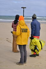
In February of 2021, scientists from the USGS Woods Hole Coastal and Marine Science Center and Woods Hole Oceanographic Institution (WHOI) conducted near-shore bathymetric surveys on Cape Cod National Seashore. Bathymetry is the study of underwater depth of ocean floors or lake floors. By collecting data and plotting points on our beaches with cameras, survey equipment, and even a surf-capable autonomous surface vessel (ASV), scientists can learn more about the dynamic processes shaping our coasts. The knowledge gained from this research will improve computer-derived simulations of coastal flooding and shoreline change that communities can use to identify hazards in areas vulnerable to storms, chronic erosion, and sea-level rise.
Sources/Usage
Public Domain.