
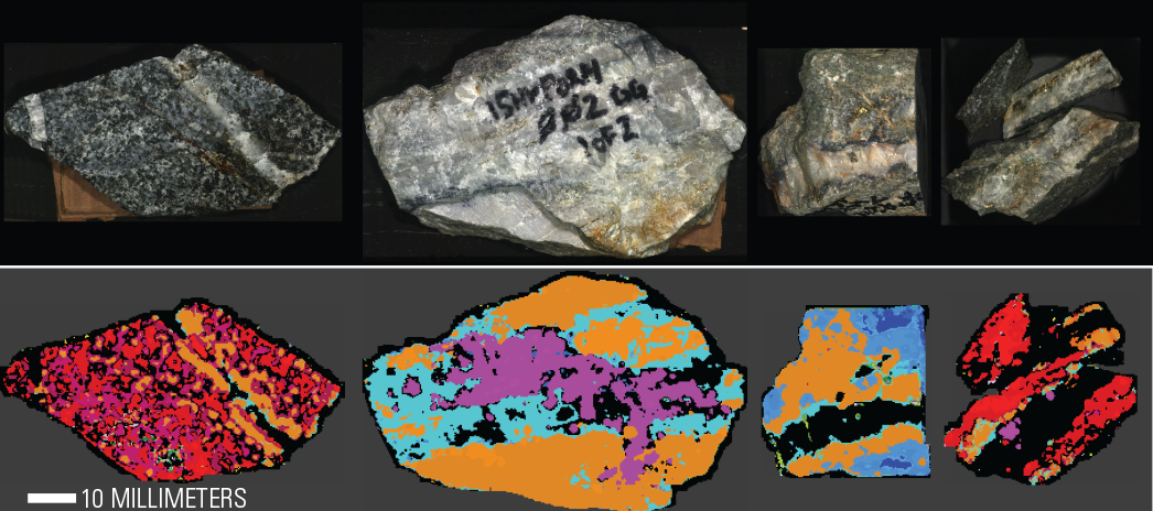
figHand specimen photograph and mineral classification map
Detailed Description
Hand specimen photograph (top) and mineral classification map (bottom) from Corescan data for selected hand specimens collected at the Orange Hill deposit. Data collected at 500-micron spatial resolution.
Sources/Usage
Public Domain.
Related

Development and Validation of Hyperspectral Imager for Field and Lab Scanning
The Mineral Resources Program has advanced methods of imaging spectroscopy (hyperspectral remote sensing) that are now used routinely by the earth science and remote sensing communities for mineral mapping, soil quality mapping, hazard mitigation, and other terrestrial and planetary applications. The USGS is highly qualified to advance this technology based on its world class expertise in mineral...
Related
Development and Validation of Hyperspectral Imager for Field and Lab Scanning
The Mineral Resources Program has advanced methods of imaging spectroscopy (hyperspectral remote sensing) that are now used routinely by the earth science and remote sensing communities for mineral mapping, soil quality mapping, hazard mitigation, and other terrestrial and planetary applications. The USGS is highly qualified to advance this technology based on its world class expertise in mineral...