
Geologic Map - St. Francois Mountains Terrane

Detailed Description
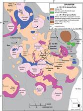
Simplified regional geologic map of Mesoproterozoic rocks in St. Francois Mountains terrane, showing distribution of volcanic and intrusive rocks, caldera boundaries, and mineral deposits and prospects. Modified from Kisvarsanyi (1981). From Day and others, 2016, doi:10.2113/econgeo.111.8.1825.
Sources/Usage
Public Domain.
Day and others, 2016, doi:10.2113/econgeo.111.8.1825.
Day, W.C., Slack, J.F., Ayuso, R.A., and Seeger, C.M., 2016, Regional Geologic and Petrologic Framework for Iron Oxide ± Apatite ± Rare Earth Element and Iron Oxide Copper-Gold Deposits of the Mesoproterozoic St. Francois Mountains Terrane, Southeast Missouri, USA: Economic Geology, 111(8), p. 1825–1858, doi:10.2113/econgeo.111.8.1825.
Related

Iron Oxide-Copper-Cobalt-Gold-Rare Earth Element Deposits of Southeast Missouri—From the Ore Deposit Scale to a Global Deposit Model
The project main objectives are to: 1) geologically, characterize the setting and origin of the iron-copper-cobalt-gold-rare earth element deposits, and advance the knowledge of rare earth element and Co potential within iron oxide-copper-gold (IOCG) deposits of southeast Missouri, and 2) geophysically delineate and characterize the subsurface Precambrian geology using existing ground and new...
Related
Iron Oxide-Copper-Cobalt-Gold-Rare Earth Element Deposits of Southeast Missouri—From the Ore Deposit Scale to a Global Deposit Model
The project main objectives are to: 1) geologically, characterize the setting and origin of the iron-copper-cobalt-gold-rare earth element deposits, and advance the knowledge of rare earth element and Co potential within iron oxide-copper-gold (IOCG) deposits of southeast Missouri, and 2) geophysically delineate and characterize the subsurface Precambrian geology using existing ground and new...