
Glacial Isostatic Adjustment

Detailed Description
Glacial isostacy is the upward or downward land motion caused by the weight of ice sheets deforming the Earth's crust. The weight of the ice sheet deforms the underlying crust downward and displaces the underlying lithosphere, creating an indentation. Raised ridges called forebulges form at the edges of the ice sheet from where displaced mantle rock causes the crust to bulge upward. When the ice sheets retreat, the forebulges slowly collapse while the indentation rebounds. This is called post-glacial isostatic adjustment.
Sources/Usage
Public Domain.
Related

The Virginia Extensometer Network
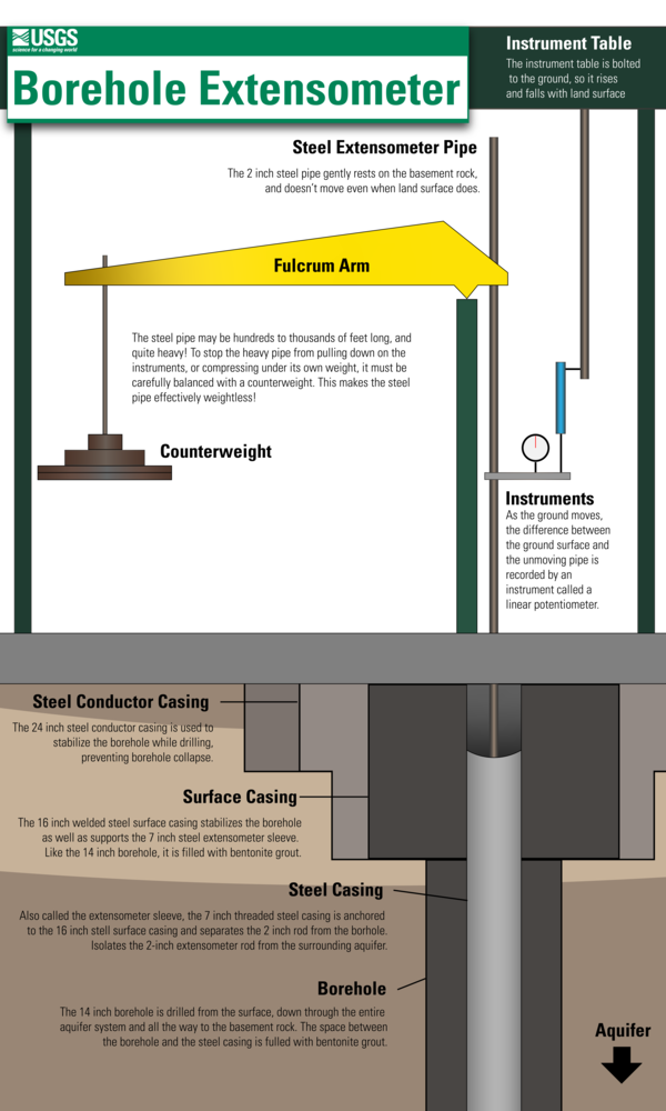
Borehole extensometers are instruments that monitor land subsidence caused by aquifer compaction. They provide precise, high-resolution measurements of changes in aquifer-system thickness. These changes in aquifer-system thickness contribute to vertical land motion (VLM) across the Virginia Coastal Plain, and are driven primarily by groundwater level decline due to human water usage. The Virginia...

Land Subsidence on the Virginia Coastal Plain
Land subsidence is a loss of ground elevation, often experienced as the ground slowly sinking over the course of years. In eastern Virginia, high rates of groundwater use is a major factor in the land subsidence affecting the area. The Virginia-West Virginia Water Science Center, with the help of our partners, has been monitoring land subsidence in the Virginia Coastal Plain since 1979 using a...
Subsidence Infographics
Subsidence Infographics


Related
The Virginia Extensometer Network
Borehole extensometers are instruments that monitor land subsidence caused by aquifer compaction. They provide precise, high-resolution measurements of changes in aquifer-system thickness. These changes in aquifer-system thickness contribute to vertical land motion (VLM) across the Virginia Coastal Plain, and are driven primarily by groundwater level decline due to human water usage. The Virginia...
Land Subsidence on the Virginia Coastal Plain
Land subsidence is a loss of ground elevation, often experienced as the ground slowly sinking over the course of years. In eastern Virginia, high rates of groundwater use is a major factor in the land subsidence affecting the area. The Virginia-West Virginia Water Science Center, with the help of our partners, has been monitoring land subsidence in the Virginia Coastal Plain since 1979 using a...
Subsidence Infographics
Subsidence Infographics