
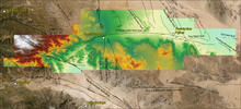
Hillshade of lidar acquired within the Pinto Mountain Fault Zone

Detailed Description
The image shown displays a portion of the lidar data collected by the USGS for the SAFSOC Project. Our goal is to study and map surficial processes and landforms related to tectonism, specifically the San Andreas Fault system. With computer processing to remove vegetation, highly accurate, bare-earth digital elevation models of the ground surface are derived to aid in more accurately mapping fault scarps, lineaments, landslides, and geology.
Sources/Usage
Public Domain.
Related

San Andreas Fault System in Southern California
Southern California is home to nearly 24 million people and countless visitors who live, recreate, consume resources, and face the risk of natural hazards in the region. This project produces high-quality, multi-purpose geologic maps, databases, and reports that portray our understanding of the region’s four-dimensional geologic framework. We conduct stratigraphic, structural, geomorphological...
Related
San Andreas Fault System in Southern California
Southern California is home to nearly 24 million people and countless visitors who live, recreate, consume resources, and face the risk of natural hazards in the region. This project produces high-quality, multi-purpose geologic maps, databases, and reports that portray our understanding of the region’s four-dimensional geologic framework. We conduct stratigraphic, structural, geomorphological...