
Landsat 8 captures flooding along the Missouri River 2019

Detailed Description
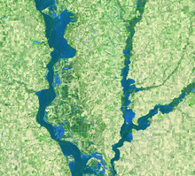
In March 2019, a warm spell that contained heavy rainfall caused snow covering the landscape (up to 3 feet in some areas) to quickly melt, and caused major flooding in the U.S. Midwest. Overall, the "The Great Flood of 2019" greatly affected the Missouri River and its tributaries in South Dakota, Iowa, Nebraska, Missouri, and Kansas.
This Landsat 8 image shows an area south of Omaha, Nebraska, south to where the Missouri/Iowa/Nebraska State lines meet. The Missouri River can be seen in the center of the image, while the Nishnabotna River flows in from the right. The normal boundary of the Missouri is discernable like a thin snake-like appearance within the water logged areas. The flooding also caused the closure of Interstate highways in the affected area for months after the waters receded. Interstate 29 runs vertical just east (right) of the Missouri River, can can be seen covered with water in the upper central part of this image.
Landsat 8
Path 28 Row 32
Acquired March 16, 2019
Bands 6,5,4
Sources/Usage
Public Domain.