

South Dakota is home to the fabled “Black Hills.” Seen from a distance, these pine-covered hills, rising several thousand feet above the surrounding prairie, appear black.
Landsat 8
Landsat 8
Explore research, stories, and images featuring the satellites
Explore research, stories, and images featuring the satellites
The first Landsat satellite launched in the 21st century, Landsat 8 provides vital information with two improved instruments.
Landsat 8 Launch: February 11, 2013
Landsat 8 Launch: February 11, 2013

This video was published for the 5th anniversary, shows the satellite's launch.
Celebrating a Decade of Data
Celebrating a Decade of Data

Landsat 8 celebrates its tenth anniversary. The technology of the satellite and its instruments, revolutionary in 2013, continues to provide important and timely data for scientific observation of the Earth’s land surfaces.
Media

Sources/Usage: Public Domain. View Media Details
Landsat 8 (formerly the Landsat Data Continuity Mission, or LDCM) was launched on an Atlas-V rocket from Vandenberg Air Force Base, California on February 11, 2013. The satellite carries the Operational Land Imager (OLI) and the Thermal Infrared Sensor (TIRS) instruments.
The OLI measures in the visible, near infrared, and shortwave infrared portions (VNIR, NIR, and SWIR) of the spectrum. The TIRS measures land surface temperature in two thermal bands with a new technology that applies quantum physics to detect heat. Landsat 8 images have 15-meter panchromatic and 30-meter multi-spectral spatial resolutions along a 185 km (115 mi) swath.
Media

Sources/Usage: Public Domain. View Media Details
Landsat 8 Satellite Orbit Facts
- Orbits the Earth in a sun-synchronous, near-polar orbit (98.2 degrees inclination)
- Achieved an altitude of 705 km (438 mi)
- Completes one Earth orbit every 99 minutes
- Has a 16-day repeat cycle with an equatorial crossing time of 10:12 a.m. +/- 5 minutes
- 8-day offset with Landsat 9
- Acquires about 750 scenes a day on the Worldwide Reference System-2 (WRS-2) path/row system, with a swath overlap (or sidelap) varying from 7 percent at the equator to a maximum of approximately 85 percent at extreme latitudes
Landsat 8 Instruments
Landsat 8 carries two sensors. The Operational Land Imager sensor is built by Ball Aerospace & Technologies Corporation. The Thermal Infrared Sensor is built by NASA Goddard Space Flight Center.
Operational Land Imager (OLI)
- Nine spectral bands, including a pan band:
- Band 1 Coastal Aerosol (0.43 - 0.45 µm) 30 m
- Band 2 Blue (0.450 - 0.51 µm) 30 m
- Band 3 Green (0.53 - 0.59 µm) 30 m
- Band 4 Red (0.64 - 0.67 µm) 30 m
- Band 5 Near-Infrared (0.85 - 0.88 µm) 30 m
- Band 6 SWIR 1(1.57 - 1.65 µm) 30 m
- Band 7 SWIR 2 (2.11 - 2.29 µm) 30 m
- Band 8 Panchromatic (PAN) (0.50 - 0.68 µm) 15 m
- Band 9 Cirrus (1.36 - 1.38 µm) 30 m
OLI captures data with improved radiometric precision over a 12-bit dynamic range, which improves overall signal to noise ratio. This translates into 4096 potential grey levels, compared with only 256 grey levels in Landsat 1-7 8-bit instruments. Improved signal to noise performance enables improved characterization of land cover state and condition.
The 12-bit data are scaled to 16-bit integers and delivered in the Level-1 data products. Products are scaled to 55,000 grey levels, and can be rescaled to the Top of Atmosphere (TOA) reflectance and/or radiance using radiometric rescaling coefficients provided in the product metadata file (MTL file).
Thermal Infrared Sensor (TIRS)
- Two spectral bands:
- Band 10 TIRS 1 (10.6 - 11.19 µm) 100 m
- Band 11 TIRS 2 (11.5 - 12.51 µm) 100 m
Landsat 8 Spacecraft Facts
- Built by Orbital Science Corporation
- 3.14 terabit solid-state data recorder
- Power provided by a single 9 x 0.4 meter solar array and one 125 Ampere-Hour (AHr), Nickel-Hydrogen (NiH2) battery
- Weight: 2,071 kg (4,566 lbs) fully loaded with fuel (without instruments)
- Length: 3 m (9.8 ft)
- Diameter: 2.4 m (7.9 ft)
- Direct Downlink with Solid State Recorders (SSR)
- Data rate: 384 Mbps on X-band frequency; 260.92 Mbps on S-band frequency
Landsat 8 Data Products
Landsat 8 data products are consistent with all Landsat standard Level-1 data products, using the specifications described on the Landsat Processing Details page.
Landsat 8 Pre-WRS-2 Data Products
Nearly 10,000 scenes were acquired by OLI/TIRS after launch (February 11, 2013) through April 10, 2013, when the satellite achieved operational orbit (WRS-2). The earliest images are TIRS data only. These data are also visible and can be downloaded from EarthExplorer.
While these data meet the quality standards and have the same geometric precision as data acquired on and after April 11, 2013, the geographic extents of each scene may differ. Most data are processed to the highest level possible, however there may be some differences in the spatial resolution of the early TIRS images due to telescope temperature changes, but they should be within +/- 1 percent.
Landsat 8 Data Users Handbook
Additional Resources
- Landsat Project Documentation
- Landsat 8 Information (NASA Landsat Science)
- Landsat 8 Underfly with Landsat 7: In March 2013, the Landsat 8 satellite was in position under Landsat 7 to collect near-coincident data for calibration activities.
- Landsat 8 Mission Milestones
- Landsat Data Continuity Mission (LDCM) Information
- LDCM Launch videos (NASA on YouTube)
- LDCM First Light Image
Related

Eyes on Earth Episode 90 – Landsat 8 Turns 10
Eyes on Earth is a podcast on remote sensing, Earth observation, land change and science, brought to you by the USGS Earth Resources Observation and Science (EROS) Center. In this episode, we reflect on Landsat 8’s 10th anniversary and the satellite’s contribution of 2.5 million scenes to the 50-year Landsat archive.

Eyes on Earth Episode 78 – Landsat 50 Lookback
Eyes on Earth is a podcast on remote sensing, Earth observation, land change and science, brought to you by the USGS Earth Resources Observation and Science (EROS) Center. In this episode, we look back at how past guests viewed the value of Landsat satellites and their 50-year history.

Landsat 8: 5-Year Anniversary
February 11 will mark the 5th anniversary of the launch of Landsat 8! Since 2013, over 1.1 million scenes have been acquired, adding to the Landsat archive which started almost 45 years ago, and continue to help support studies in agriculture, forest and water quality/use/management, natural disasters, and land change. The Landsat Program is a series of Earth-observing satellites co-managed by...
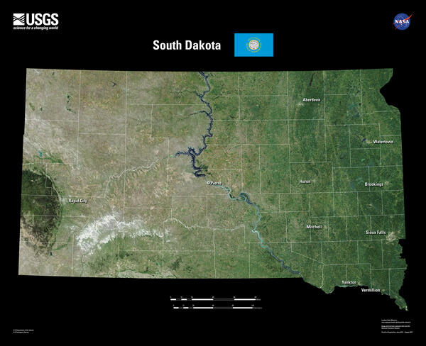
South Dakota Landsat 8 Mosaic
South Dakota is home to the fabled “Black Hills.” Seen from a distance, these pine-covered hills, rising several thousand feet above the surrounding prairie, appear black.

Eyes on Earth Episode 90 – Landsat 8 Turns 10
Originally called the Landsat Data Continuity Mission, Landsat 8 launched on February 11, 2013. In this episode of Eyes on Earth, we talk about the 10^th^ anniversary of Landsat 8 being in orbit and its value to the remote sensing community.
Originally called the Landsat Data Continuity Mission, Landsat 8 launched on February 11, 2013. In this episode of Eyes on Earth, we talk about the 10^th^ anniversary of Landsat 8 being in orbit and its value to the remote sensing community.

Landsat 8 image of California Central Coast
This Landsat 8 image of a portion of the Central Coast of California (WRS2 Path 43 Row 35) was acquired on January 31, 2023. Bands 6,5,4
This Landsat 8 image of a portion of the Central Coast of California (WRS2 Path 43 Row 35) was acquired on January 31, 2023. Bands 6,5,4

Landsat 8 Image of Sacramento Valley on Jan 22, 2023
Landsat 8 Image of Sacramento Valley on Jan 22, 2023This natural color Landsat 8 image of the Sacramento Valley area shows the impacts of the relentless rains that impacted the area during the end of December and into the New Year. Turbid river water, saturated fields, and rising reservoirs can be seen near Stockton and Sacramento.

Landsat 8 Image of Washburn Fire, Yosemite National Park - July 7, 2022
Landsat 8 Image of Washburn Fire, Yosemite National Park - July 7, 2022The Landsat 8 thermal image of the Washburn fire was acquired at night to pinpoint the location (bright white) of heat from the fire as it began. Firefighters immediately focused on suppressing the wildfire to minimize any effects on the Mariposa Grove of Giant Sequoias. As of July 18, 2022, the fire covered nearly 5,000 acres.

Landsat 8 Image of the Great Salt Lake in July, 2022
Landsat 8 Image of the Great Salt Lake in July, 2022Natural Color Landsat 8 image of the Great Salt Lake, acquired on July 3, 2022. On July 3, the level of Great Salt Lake dropped below the October 2021 historic low elevation.
Landsat 8 Image of the Great Salt Lake in July, 2022
Landsat 8 Image of the Great Salt Lake in July, 2022Natural Color Landsat 8 image of the Great Salt Lake, acquired on July 3, 2022. On July 3, the level of Great Salt Lake dropped below the October 2021 historic low elevation.

Landsat 8 Thermal Infrared Sensor Image near Ogallala, Nebraska
Landsat 8 Thermal Infrared Sensor Image near Ogallala, NebraskaLandsat 8 thermal infrared (Band 10) image near Ogallala, Nebraska, showing fields with center pivot irrigation. The Thermal Infrared Sensor (TIRS) on Landsat 8-9 measures energy radiated by the earth of the surface with two spectral bands that can be used to derive surface temperature.
The image was acquired on August 17, 2021 from Path 31 Row 32.

Landsat 8 image of Karymsky volcano, April 20, 2022
Landsat 8 image of Karymsky volcano, April 20, 2022Karymsky volcano, one of the most active volcanoes of Kamchatka's eastern volcanic zone, erupted on April 20, 2022. This pan-sharpened Landsat 8 image captured the event. Overlaying the infrared data over the natural color image highlights the heat signature of the active flows.
Landsat ID: LC08_L1TP_098022_20220420_20220420_02_RT

Landsat 8 Image of Lake St. Clair
Landsat captured the tug of war between winter and spring on the heart-shaped Lake St. Clair along the U.S./Canadian border near Detroit.
This Landsat 8 image was acquired on March 6, 2021 and is shown as a natural color composite.
Learn more about the Landsat program at www.usgs.gov/landsat
Landsat captured the tug of war between winter and spring on the heart-shaped Lake St. Clair along the U.S./Canadian border near Detroit.
This Landsat 8 image was acquired on March 6, 2021 and is shown as a natural color composite.
Learn more about the Landsat program at www.usgs.gov/landsat

Earth as Art - Landsat 8
This image titled "Bleeding Heart" is one of many contained in the 5th Earth as Art collection.
Visit https://eros.usgs.gov/media-gallery/earth-as-art to view the entire group of Earth as Art collections.
This image titled "Bleeding Heart" is one of many contained in the 5th Earth as Art collection.
Visit https://eros.usgs.gov/media-gallery/earth-as-art to view the entire group of Earth as Art collections.

Landsat 8 Completes 5 Years of Operation
USGS Scientists John Dwyer and Tom Loveland from EROS discuss the major accomplishments of Landsat 8 as it reaches it's 5 year design life. The Landsat program started in 1972, and has a bright future thanks to these extraordinary satellites.
USGS Scientists John Dwyer and Tom Loveland from EROS discuss the major accomplishments of Landsat 8 as it reaches it's 5 year design life. The Landsat program started in 1972, and has a bright future thanks to these extraordinary satellites.

Every Pixel - Landsat's Sensors
On board Landsat 8 are two sensors that capture data about earth's surface. Here is an explanation of the instruments that capture every pixel.
On board Landsat 8 are two sensors that capture data about earth's surface. Here is an explanation of the instruments that capture every pixel.

Every Pixel - Landsat's Orbit
Ever wonder how Landsat 8 orbits our planet? Here is an overview to explain this part of how we capture every pixel.
Ever wonder how Landsat 8 orbits our planet? Here is an overview to explain this part of how we capture every pixel.

Landsat 8 Collects 1 Millionth Scene
Landsat 8 collects it's 1 millionth scene. See it for yourself!
Landsat 8 collects it's 1 millionth scene. See it for yourself!

Landsat 8 Swath Animation
The Earth Resources Observation and Science (EROS) Center has created a video animation describing how Landsat 8 orbits the Earth. The video explains the 16-day cycle for capturing imagery of the entire world.
The Earth Resources Observation and Science (EROS) Center has created a video animation describing how Landsat 8 orbits the Earth. The video explains the 16-day cycle for capturing imagery of the entire world.

Anatomy of Landsat 8
Have you ever wondered what all the parts of a satellite do? This video identifies a few of the main components onboard Landsat 8 and tells you about their role in flying the satellite and capturing images of the Earth's surface below. Learn more about USGS Landsat.
Have you ever wondered what all the parts of a satellite do? This video identifies a few of the main components onboard Landsat 8 and tells you about their role in flying the satellite and capturing images of the Earth's surface below. Learn more about USGS Landsat.

How is the Landsat 8 and Landsat 9 Cirrus Band 9 used? How is the Landsat 8 and Landsat 9 Cirrus Band 9 used?
The Operational Land Imager’s Band 9 1.360-1.390 µm on Landsat 8 and Landsat 9 detects thin, high-altitude clouds composed of ice crystals that might not be visible in other spectral bands. In Band 9, cirrus clouds appear bright while most land surfaces appear dark through an otherwise cloud-free atmosphere containing water vapor. Learn more: Landsat 8 Mission Landsat 9 Mission Landsat 8 & 9 bands...

How is the Landsat 8 and Landsat 9 Coastal/Aerosol Band 1 used? How is the Landsat 8 and Landsat 9 Coastal/Aerosol Band 1 used?
The Operational Land Imager Band 1 ( 0.433-0.453 µm) on Landsat 8 and Landsat 9 is useful for imaging shallow water and tracking fine atmospheric particles like dust and smoke. Band 1 reflects blues and violets, where light is scattered by dust, smoke, and water particles in the air. Collecting data with enough sensitivity at this spectrum is difficult. Since water absorbs and scatters light...
Related
Eyes on Earth Episode 90 – Landsat 8 Turns 10
Eyes on Earth is a podcast on remote sensing, Earth observation, land change and science, brought to you by the USGS Earth Resources Observation and Science (EROS) Center. In this episode, we reflect on Landsat 8’s 10th anniversary and the satellite’s contribution of 2.5 million scenes to the 50-year Landsat archive.
Eyes on Earth Episode 78 – Landsat 50 Lookback
Eyes on Earth is a podcast on remote sensing, Earth observation, land change and science, brought to you by the USGS Earth Resources Observation and Science (EROS) Center. In this episode, we look back at how past guests viewed the value of Landsat satellites and their 50-year history.
Landsat 8: 5-Year Anniversary
February 11 will mark the 5th anniversary of the launch of Landsat 8! Since 2013, over 1.1 million scenes have been acquired, adding to the Landsat archive which started almost 45 years ago, and continue to help support studies in agriculture, forest and water quality/use/management, natural disasters, and land change. The Landsat Program is a series of Earth-observing satellites co-managed by...
South Dakota Landsat 8 Mosaic
South Dakota is home to the fabled “Black Hills.” Seen from a distance, these pine-covered hills, rising several thousand feet above the surrounding prairie, appear black.
South Dakota is home to the fabled “Black Hills.” Seen from a distance, these pine-covered hills, rising several thousand feet above the surrounding prairie, appear black.
Eyes on Earth Episode 90 – Landsat 8 Turns 10
Originally called the Landsat Data Continuity Mission, Landsat 8 launched on February 11, 2013. In this episode of Eyes on Earth, we talk about the 10^th^ anniversary of Landsat 8 being in orbit and its value to the remote sensing community.
Originally called the Landsat Data Continuity Mission, Landsat 8 launched on February 11, 2013. In this episode of Eyes on Earth, we talk about the 10^th^ anniversary of Landsat 8 being in orbit and its value to the remote sensing community.
Landsat 8 image of California Central Coast
This Landsat 8 image of a portion of the Central Coast of California (WRS2 Path 43 Row 35) was acquired on January 31, 2023. Bands 6,5,4
This Landsat 8 image of a portion of the Central Coast of California (WRS2 Path 43 Row 35) was acquired on January 31, 2023. Bands 6,5,4
Landsat 8 Image of Sacramento Valley on Jan 22, 2023
Landsat 8 Image of Sacramento Valley on Jan 22, 2023This natural color Landsat 8 image of the Sacramento Valley area shows the impacts of the relentless rains that impacted the area during the end of December and into the New Year. Turbid river water, saturated fields, and rising reservoirs can be seen near Stockton and Sacramento.
Landsat 8 Image of Washburn Fire, Yosemite National Park - July 7, 2022
Landsat 8 Image of Washburn Fire, Yosemite National Park - July 7, 2022The Landsat 8 thermal image of the Washburn fire was acquired at night to pinpoint the location (bright white) of heat from the fire as it began. Firefighters immediately focused on suppressing the wildfire to minimize any effects on the Mariposa Grove of Giant Sequoias. As of July 18, 2022, the fire covered nearly 5,000 acres.
Landsat 8 Image of the Great Salt Lake in July, 2022
Landsat 8 Image of the Great Salt Lake in July, 2022Natural Color Landsat 8 image of the Great Salt Lake, acquired on July 3, 2022. On July 3, the level of Great Salt Lake dropped below the October 2021 historic low elevation.
Landsat 8 Image of the Great Salt Lake in July, 2022
Landsat 8 Image of the Great Salt Lake in July, 2022Natural Color Landsat 8 image of the Great Salt Lake, acquired on July 3, 2022. On July 3, the level of Great Salt Lake dropped below the October 2021 historic low elevation.
Landsat 8 Thermal Infrared Sensor Image near Ogallala, Nebraska
Landsat 8 Thermal Infrared Sensor Image near Ogallala, NebraskaLandsat 8 thermal infrared (Band 10) image near Ogallala, Nebraska, showing fields with center pivot irrigation. The Thermal Infrared Sensor (TIRS) on Landsat 8-9 measures energy radiated by the earth of the surface with two spectral bands that can be used to derive surface temperature.
The image was acquired on August 17, 2021 from Path 31 Row 32.
Landsat 8 image of Karymsky volcano, April 20, 2022
Landsat 8 image of Karymsky volcano, April 20, 2022Karymsky volcano, one of the most active volcanoes of Kamchatka's eastern volcanic zone, erupted on April 20, 2022. This pan-sharpened Landsat 8 image captured the event. Overlaying the infrared data over the natural color image highlights the heat signature of the active flows.
Landsat ID: LC08_L1TP_098022_20220420_20220420_02_RT
Landsat 8 Image of Lake St. Clair
Landsat captured the tug of war between winter and spring on the heart-shaped Lake St. Clair along the U.S./Canadian border near Detroit.
This Landsat 8 image was acquired on March 6, 2021 and is shown as a natural color composite.
Learn more about the Landsat program at www.usgs.gov/landsat
Landsat captured the tug of war between winter and spring on the heart-shaped Lake St. Clair along the U.S./Canadian border near Detroit.
This Landsat 8 image was acquired on March 6, 2021 and is shown as a natural color composite.
Learn more about the Landsat program at www.usgs.gov/landsat
Earth as Art - Landsat 8
This image titled "Bleeding Heart" is one of many contained in the 5th Earth as Art collection.
Visit https://eros.usgs.gov/media-gallery/earth-as-art to view the entire group of Earth as Art collections.
This image titled "Bleeding Heart" is one of many contained in the 5th Earth as Art collection.
Visit https://eros.usgs.gov/media-gallery/earth-as-art to view the entire group of Earth as Art collections.
Landsat 8 Completes 5 Years of Operation
USGS Scientists John Dwyer and Tom Loveland from EROS discuss the major accomplishments of Landsat 8 as it reaches it's 5 year design life. The Landsat program started in 1972, and has a bright future thanks to these extraordinary satellites.
USGS Scientists John Dwyer and Tom Loveland from EROS discuss the major accomplishments of Landsat 8 as it reaches it's 5 year design life. The Landsat program started in 1972, and has a bright future thanks to these extraordinary satellites.
Every Pixel - Landsat's Sensors
On board Landsat 8 are two sensors that capture data about earth's surface. Here is an explanation of the instruments that capture every pixel.
On board Landsat 8 are two sensors that capture data about earth's surface. Here is an explanation of the instruments that capture every pixel.
Every Pixel - Landsat's Orbit
Ever wonder how Landsat 8 orbits our planet? Here is an overview to explain this part of how we capture every pixel.
Ever wonder how Landsat 8 orbits our planet? Here is an overview to explain this part of how we capture every pixel.
Landsat 8 Collects 1 Millionth Scene
Landsat 8 collects it's 1 millionth scene. See it for yourself!
Landsat 8 collects it's 1 millionth scene. See it for yourself!
Landsat 8 Swath Animation
The Earth Resources Observation and Science (EROS) Center has created a video animation describing how Landsat 8 orbits the Earth. The video explains the 16-day cycle for capturing imagery of the entire world.
The Earth Resources Observation and Science (EROS) Center has created a video animation describing how Landsat 8 orbits the Earth. The video explains the 16-day cycle for capturing imagery of the entire world.
Anatomy of Landsat 8
Have you ever wondered what all the parts of a satellite do? This video identifies a few of the main components onboard Landsat 8 and tells you about their role in flying the satellite and capturing images of the Earth's surface below. Learn more about USGS Landsat.
Have you ever wondered what all the parts of a satellite do? This video identifies a few of the main components onboard Landsat 8 and tells you about their role in flying the satellite and capturing images of the Earth's surface below. Learn more about USGS Landsat.
How is the Landsat 8 and Landsat 9 Cirrus Band 9 used? How is the Landsat 8 and Landsat 9 Cirrus Band 9 used?
The Operational Land Imager’s Band 9 1.360-1.390 µm on Landsat 8 and Landsat 9 detects thin, high-altitude clouds composed of ice crystals that might not be visible in other spectral bands. In Band 9, cirrus clouds appear bright while most land surfaces appear dark through an otherwise cloud-free atmosphere containing water vapor. Learn more: Landsat 8 Mission Landsat 9 Mission Landsat 8 & 9 bands...
How is the Landsat 8 and Landsat 9 Coastal/Aerosol Band 1 used? How is the Landsat 8 and Landsat 9 Coastal/Aerosol Band 1 used?
The Operational Land Imager Band 1 ( 0.433-0.453 µm) on Landsat 8 and Landsat 9 is useful for imaging shallow water and tracking fine atmospheric particles like dust and smoke. Band 1 reflects blues and violets, where light is scattered by dust, smoke, and water particles in the air. Collecting data with enough sensitivity at this spectrum is difficult. Since water absorbs and scatters light...