
Landsat 9 Collection 2 Level-2 Science Product Example

Detailed Description
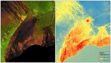
These images of Hawaii’s Kilauea Volcano, captured on January 25, 2022, show two of the USGS science products built from imagery collected by the Landsat 9 satellite. The left image shows Landsat surface reflectance, a product that removes atmospheric interference to best mirror on-the-ground conditions, as recorded here in the short-wave infrared, near infrared and red bands of the electromagnetic spectrum. On the right is the same image seen through the lens of the Landsat surface temperature product, which records temperature in Kelvin.
Landsat Scene ID LC09_L1TP_062047_20220125_20220126_02_T1
Sources/Usage
Public Domain.
Related

USGS EROS Archive - Landsat Archives - Landsat 8-9 OLI/TIRS Collection 2 Level-2 Science Products
Landsat 8-9 Operational Land Imager (OLI) and Thermal Infrared (TIRS) Collection 2 Level-2 Science Products 30-meter multispectral data.
Related
USGS EROS Archive - Landsat Archives - Landsat 8-9 OLI/TIRS Collection 2 Level-2 Science Products
Landsat 8-9 Operational Land Imager (OLI) and Thermal Infrared (TIRS) Collection 2 Level-2 Science Products 30-meter multispectral data.