
Landslide Spreads 6 Miles Across Glacier Bay National Park

Detailed Description
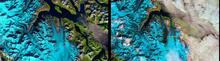
On June 28, 2016, a 4,000-foot-high mountainside in Glacier Bay National Park and Preserve collapsed, sending rocky debris equivalent to 60 million mid-size SUVs tumbling onto nearby Lamplugh Glacier. Almost 6 weeks later, on August 7, the Operational Land Imager sensor aboard Landsat 8 captured the black stain of the landslide in the image on the right. No such discoloration is evident in the Landsat image to the left, acquired on September 13 of the previous year.
Sources/Usage
Public Domain.