
Location map showing land loss (red) from 1932 to 2004

Detailed Description
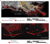
Location map showing land loss (red) from 1932 to 2004 for Louisiana coast (A) and study area (B). Land loss in southern coastal Louisiana is caused by conversion of marsh to open water. Land loss data used in figure is from Morton and others (2010) and Barras and others (2008).
Sources/Usage
Public Domain.
Related

Subsidence and Coastal Geomorphic Change in South-Central Louisiana
New methods will investigate coastal subsidence on and around barrier islands before and after restoration.
Related
Subsidence and Coastal Geomorphic Change in South-Central Louisiana
New methods will investigate coastal subsidence on and around barrier islands before and after restoration.