
Subsidence and Coastal Geomorphic Change in South-Central Louisiana
New methods will investigate coastal subsidence on and around barrier islands before and after restoration.

This research is part of the Geologic and Morphologic Evolution of Coastal Margins project.
High historical land-loss rates in coastal Louisiana have resulted in the conversion of approximately 5000 square kilometers (km2) of formerly emergent wetlands to open water since the 1930s. Evaluating subsidence is complicated because rates are highly variable both spatially and temporally.
- Subsidence rates vary in space, potentially over very short distances (for example, tens of meters)
- Subsidence rates vary as a function of depth; the nature of this function can vary substantially across space and is dependent upon sedimentology (rates are always highest at the surface!)
- Subsidence rates can vary through time, depending on the driving processes
Geologic Processes Driving Coastal Subsidence
- Physical processes driving subsidence such as faulting or sediment compaction can occur individually or in combination, creating a complex system of drivers.
- Processes deep in the Earth's crust (for example, faulting or flexure of the lithosphere) contribute relatively little to land-surface subsidence rates (typically less than 1 millimeter per year in aggregate).
- Deltaic sediment loading leads to short-term lithospheric subsidence rates in key portions of the Mississippi Delta of about 0.15 plus or minus 0.07 millimeters per year. Rates are lower in the Chenier Plain west of the Delta Plain where Holocene sediments are much thinner.
- The common, long-term process that drives lithospheric subsidence throughout the Gulf of America is glacial isostatic adjustment (at least 0.4 millimeters per year along the central United States Gulf Coast).
- Sediment compaction, fluid extraction, growth faulting, and saltwater intrusion potentially contribute significantly to coastal subsidence but the relative importance of these processes is still poorly understood because of their spatial and temporal variability.
Barrier Island and Barrier Shoreline Subsidence - Stratigraphic Compaction Relative to Restoration
Relative sea-level rise and subsidence are leading to the inundation of shorelines, barrier islands, and wetlands of Louisiana, Mississippi, Texas, and Alabama. Reed (2009) reported that observed rates of subsidence span two orders of magnitude in coastal Louisiana with the largest values exceeding 10.0 millimeters (0.4 inches) per year [0.91 meters (3 feet) per century]. A relative decrease in elevation (subsidence) with respect to sea level results in land and habitat loss, and endangers infrastructure and ecosystem health in and around Louisiana’s coastal communities by increasing the likelihood of flooding and damage from storms.

The focus of this study is subsidence induced by shallow compaction over the past 10,000 years and relative sea-level rise rates impacting coastal shorelines, barrier and marsh islands, and nearshore coastal systems. As a part of this study, several types of data are needed to analyze the effects of subsidence on coastal change. Data types that will be analyzed include lidar, bathymetry, sediment texture and stratigraphy, and inlet hydrodynamics. These data will be used to refine and assess geomorphic models.
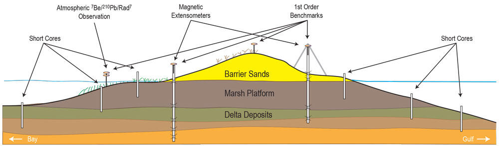
The strategy is to select a barrier island site that will be restored in the near future (for example, Isle Dernieres or Timbalier). Prior to restoration, it is necessary to characterize the physical environment including topography, bathymetry, and sedimentology of the barrier island system. First order benchmarks and extensometers will be installed to establish a baseline condition and measure future elevation change. The data collected from these tasks will be used to model potential geomorphologic change (for example, shoreline change resulting from island breaching or sediment erosion and redistribution resulting from washover processes).
Main objectives
- Identify relative elevation changes (thickness) of shallow stratigraphic units (to a depth of 20-30 meters; 85-98 feet), seafloor, marsh, and island bare earth surfaces before and after island restoration.
- Quantify nearshore bathymetric change processes (for example, erosion, accretion, and subsidence) before and after restoration.
- Evaluate inlet changes due to restoration efforts and increases in tidal volume due to subsidence and sea-level rise.
- Quantify Gulf coastal subsidence rates within the study area.
- Collect high-resolution bathymetric and seismic data for change analyses at identified sites in Teche, Lafourche, and Modern Deltas areas.
- Conduct sediment characterization of same areas.
- Model geomorphic change and overwash potential.
This research is part of the Geologic and Morphologic Evolution of Coastal Margins project.
This research is part of the Geologic and Morphologic Evolution of Coastal Margins project. Listed below are links to that project and related resarch tasks.

Geologic and Morphologic Evolution of Coastal Margins

Barrier Island Comprehensive Monitoring

Integrating Mapping and Modeling to Support the Restoration of Bird Nesting Habitat at Breton Island National Wildlife Refuge

Science Support for the Mississippi Coastal Improvement Project

Geologic Evolution of Cat Island, Mississippi
Geologic and Morphologic Evolution of Coastal Margins
New methods will investigate coastal subsidence on and around barrier islands before and after restoration.
This research is part of the Geologic and Morphologic Evolution of Coastal Margins project.
High historical land-loss rates in coastal Louisiana have resulted in the conversion of approximately 5000 square kilometers (km2) of formerly emergent wetlands to open water since the 1930s. Evaluating subsidence is complicated because rates are highly variable both spatially and temporally.
- Subsidence rates vary in space, potentially over very short distances (for example, tens of meters)
- Subsidence rates vary as a function of depth; the nature of this function can vary substantially across space and is dependent upon sedimentology (rates are always highest at the surface!)
- Subsidence rates can vary through time, depending on the driving processes
Geologic Processes Driving Coastal Subsidence
- Physical processes driving subsidence such as faulting or sediment compaction can occur individually or in combination, creating a complex system of drivers.
- Processes deep in the Earth's crust (for example, faulting or flexure of the lithosphere) contribute relatively little to land-surface subsidence rates (typically less than 1 millimeter per year in aggregate).
- Deltaic sediment loading leads to short-term lithospheric subsidence rates in key portions of the Mississippi Delta of about 0.15 plus or minus 0.07 millimeters per year. Rates are lower in the Chenier Plain west of the Delta Plain where Holocene sediments are much thinner.
- The common, long-term process that drives lithospheric subsidence throughout the Gulf of America is glacial isostatic adjustment (at least 0.4 millimeters per year along the central United States Gulf Coast).
- Sediment compaction, fluid extraction, growth faulting, and saltwater intrusion potentially contribute significantly to coastal subsidence but the relative importance of these processes is still poorly understood because of their spatial and temporal variability.
Barrier Island and Barrier Shoreline Subsidence - Stratigraphic Compaction Relative to Restoration
Relative sea-level rise and subsidence are leading to the inundation of shorelines, barrier islands, and wetlands of Louisiana, Mississippi, Texas, and Alabama. Reed (2009) reported that observed rates of subsidence span two orders of magnitude in coastal Louisiana with the largest values exceeding 10.0 millimeters (0.4 inches) per year [0.91 meters (3 feet) per century]. A relative decrease in elevation (subsidence) with respect to sea level results in land and habitat loss, and endangers infrastructure and ecosystem health in and around Louisiana’s coastal communities by increasing the likelihood of flooding and damage from storms.
The focus of this study is subsidence induced by shallow compaction over the past 10,000 years and relative sea-level rise rates impacting coastal shorelines, barrier and marsh islands, and nearshore coastal systems. As a part of this study, several types of data are needed to analyze the effects of subsidence on coastal change. Data types that will be analyzed include lidar, bathymetry, sediment texture and stratigraphy, and inlet hydrodynamics. These data will be used to refine and assess geomorphic models.
The strategy is to select a barrier island site that will be restored in the near future (for example, Isle Dernieres or Timbalier). Prior to restoration, it is necessary to characterize the physical environment including topography, bathymetry, and sedimentology of the barrier island system. First order benchmarks and extensometers will be installed to establish a baseline condition and measure future elevation change. The data collected from these tasks will be used to model potential geomorphologic change (for example, shoreline change resulting from island breaching or sediment erosion and redistribution resulting from washover processes).
Main objectives
- Identify relative elevation changes (thickness) of shallow stratigraphic units (to a depth of 20-30 meters; 85-98 feet), seafloor, marsh, and island bare earth surfaces before and after island restoration.
- Quantify nearshore bathymetric change processes (for example, erosion, accretion, and subsidence) before and after restoration.
- Evaluate inlet changes due to restoration efforts and increases in tidal volume due to subsidence and sea-level rise.
- Quantify Gulf coastal subsidence rates within the study area.
- Collect high-resolution bathymetric and seismic data for change analyses at identified sites in Teche, Lafourche, and Modern Deltas areas.
- Conduct sediment characterization of same areas.
- Model geomorphic change and overwash potential.
This research is part of the Geologic and Morphologic Evolution of Coastal Margins project.
This research is part of the Geologic and Morphologic Evolution of Coastal Margins project. Listed below are links to that project and related resarch tasks.
Geologic and Morphologic Evolution of Coastal Margins
Barrier Island Comprehensive Monitoring
Integrating Mapping and Modeling to Support the Restoration of Bird Nesting Habitat at Breton Island National Wildlife Refuge
Science Support for the Mississippi Coastal Improvement Project
Geologic Evolution of Cat Island, Mississippi