
Long-term shoreline change rates for Virginia Barrier Islands
By St. Petersburg Coastal and Marine Science Center
2016 (approx.)

Detailed Description
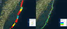
Long-term shoreline change rates for several of the Virginia Barrier Islands (left) and the historic shoreline position data used to calculate the rates (right) as viewed in the Coastal Change Hazards portal.
Sources/Usage
Public Domain.
Related

Long-Term Coastal Change
Goals of this task include developing and improving coastal-change assessments and supporting long-term planning and decision making to ensure sustainable coastal economies, infrastructure, and ecosystems.
Related
Long-Term Coastal Change
Goals of this task include developing and improving coastal-change assessments and supporting long-term planning and decision making to ensure sustainable coastal economies, infrastructure, and ecosystems.