
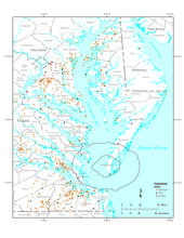
Map showing the location of the Atlantic Subsurface Stratigraphic Initiative study area in Maryland and Virginia.

Detailed Description
Map showing the location of the study area in Maryland and Virginia. Each dot represents an outcrop (red), core (black) or water well (orange) where Paleogene formation thicknesses were obtained. The circular feature in the southern portion of the map is the Chesapeake Bay Impact Crater. Paleogene sediments are not present in the crater.
Sources/Usage
Public Domain.
Related

Atlantic Subsurface Stratigraphic Initiative
The Atlantic Subsurface Stratigraphic Initiative (ASSI) is a project with an interdisciplinary group of scientists focused on documenting the Cretaceous and Cenozoic subsurface geology of the Salisbury Embayment across Maryland and Virginia. Data generated by ASSI is crucial for resolving stratigraphic issues across state boundaries and regions. By working closely with state geologic surveys, ASSI...
Related
Atlantic Subsurface Stratigraphic Initiative
The Atlantic Subsurface Stratigraphic Initiative (ASSI) is a project with an interdisciplinary group of scientists focused on documenting the Cretaceous and Cenozoic subsurface geology of the Salisbury Embayment across Maryland and Virginia. Data generated by ASSI is crucial for resolving stratigraphic issues across state boundaries and regions. By working closely with state geologic surveys, ASSI...