
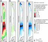
Maps showing pedestrian travel times across the Long Beach Peninsula

Detailed Description
Maps showing pedestrian travel times across the Long Beach Peninsula, Washington, based on an anisotropic modeling approach and various data sets. a Shows results of the anisotropic using 1-m elevation data and 1-m land-cover data. b–d Show the difference at each grid cell between a and b 1-m elevation and 30-m NLCD data, c 10-m elevation and 1-m land-cover data, and d 10-m elevation and 30-m NLCD data
Sources/Usage
Public Domain.
Related

Tsunamis
The 2004 Indian Ocean, 2010 Chilean, and 2011 Tohoku disasters have shown how tsunamis are significant threats to coastal communities. To help U.S. coastal communities prepare for future tsunamis, the Hazards Vulnerability Team completed projects related to population exposure and sensitivity, pedestrian evacuation modeling, and vertical-evacuation decision support. A recent article of ours in the...
Related
Tsunamis
The 2004 Indian Ocean, 2010 Chilean, and 2011 Tohoku disasters have shown how tsunamis are significant threats to coastal communities. To help U.S. coastal communities prepare for future tsunamis, the Hazards Vulnerability Team completed projects related to population exposure and sensitivity, pedestrian evacuation modeling, and vertical-evacuation decision support. A recent article of ours in the...