
May Public Lecture Flyer, 2022

Detailed Description
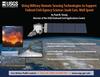
Using Military Remote Sensing Technology to Support Federal Civil Agency Science: Sunk Cost, Well Spent
By Paul M. Young, Director of the USGS National Civil Applications Center
- The USGS has a long history of using images from military and Intelligence community satellites to support our science.
- Learn how public safety, disaster response, and environmental monitoring missions are supported.
- This cooperation benefits all Americans and is an example of good government.
May 26th, 2022 at 6:00PM PT
Resource Links:
USGS EarthExplorer website: https://earthexplorer.usgs.gov/ (Imagery will be found under Data Sets "Declassified Data.")
Corona program: https://www.nro.gov/History-and-Studies/Center-for-the-Study-of-National-Reconnaissance/The-CORONA-Program/
Civil Applications Committee Fact Sheet: https://pubs.usgs.gov/fs/2022/3002/fs20223002.pdf
USGS Volcano Hazards Program: https://www.usgs.gov/programs/VHP
National Interagency Fire Center: https://www.nifc.gov/
USGS Landslide Hazards Program is mentioned: https://www.usgs.gov/programs/landslide-hazards
USGS Hazards Data Distribution System: https://hddsexplorer.usgs.gov/
International Charter (also in the slide): https://disasterscharter.org/
Sources/Usage
Public Domain.