
Modeling Sea-Level Rise in San Francisco Bay Estuary
2015 (approx.)

Detailed Description
San Francisco Bay — which has already lost the majority of its marsh habitat since the 19th Century — could lose even more marshes by the year 2100 due to sea level rise, according to a new USGS report. Animations, graphs and data from the USGS Open File Report 2013-1081 and the USGS project "Modeling Sea-Level Rise in San Francisco Bay Estuary" can be found online.
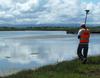
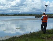
This photo shows a USGS researcher surveying marsh topography using a RTK GPS measuring unit, collecting data that was used to build the sea level rise forecasts for this USGS Open File Report.
Sources/Usage
Public Domain.