
Mount Rainier Seismicity 2010-2020

Detailed Description
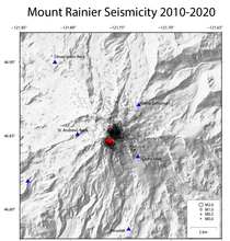
Map shows earthquakes at Mount Rainier from 2010 to 2020. Circles show earthquake epicenters, sized by magnitude. The red circles are earthquakes from a swarm that occurred February 17-18, 2021, in an area that has seen many earthquakes since 2010. Seismic stations are shown as blue triangles.
Sources/Usage
Public Domain.